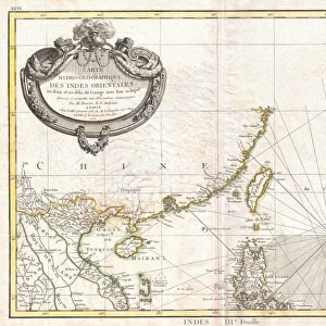
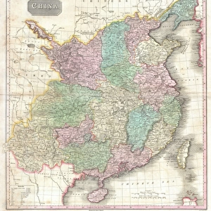
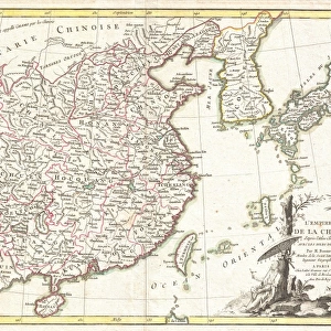
Photographic Print : 1799, Clement Cruttwell Map of China, Korea, and Taiwan, topography, cartography


![]()
Photo Prints from Liszt Collection
1799, Clement Cruttwell Map of China, Korea, and Taiwan, topography, cartography
1799, Clement Cruttwell Map of China, Korea, and Taiwan
Liszt Collection of nineteenth-century engravings and images to browse and enjoy
Media ID 14004858
© Artokoloro Quint Lox Limited
1799 Korea Antique Map Latitude Longitude Mappa Mundi Old Antique Plan Old Antique View Ols Antique Map Rare Old Maps Topo
10"x8" Photo Print
Discover the rich history and intricate detail of the past with our exquisite selection from the Media Storehouse range of Photographic Prints. This captivating piece features the 1799 Clement Cruttwell Map of China, Korea, and Taiwan from the esteemed Liszt Collection. This vintage map, showcasing the topography and cartography of the region during that era, is meticulously captured in high-definition photographic detail. Bring the beauty and knowledge of history into your home or office space with this unique and intriguing addition to your decor. A perfect gift for history buffs, cartography enthusiasts, or anyone with a passion for the past.
Photo prints are produced on Kodak professional photo paper resulting in timeless and breath-taking prints which are also ideal for framing. The colors produced are rich and vivid, with accurate blacks and pristine whites, resulting in prints that are truly timeless and magnificent. Whether you're looking to display your prints in your home, office, or gallery, our range of photographic prints are sure to impress. Dimensions refers to the size of the paper in inches.
Our Photo Prints are in a large range of sizes and are printed on Archival Quality Paper for excellent colour reproduction and longevity. They are ideal for framing (our Framed Prints use these) at a reasonable cost. Alternatives include cheaper Poster Prints and higher quality Fine Art Paper, the choice of which is largely dependant on your budget.
Estimated Product Size is 25.4cm x 20.3cm (10" x 8")
These are individually made so all sizes are approximate
Artwork printed orientated as per the preview above, with landscape (horizontal) orientation to match the source image.
EDITORS COMMENTS
This print showcases the intricate beauty of the 1799 Clement Cruttwell Map of China, Korea, and Taiwan. A true masterpiece in cartography, this vintage map takes us back in time to an era when exploration and discovery were at their peak. With its topographical details meticulously illustrated, it offers a glimpse into the geographical features of these ancient lands. The artistry displayed on this old paper map is simply awe-inspiring. The carefully crafted grid lines, latitude and longitude markings, and geometric precision demonstrate the immense skill and dedication that went into creating such a historical artifact. As we delve deeper into its rich history, we are transported to a world where navigation relied on maps like these for journeys across vast regions. This rare antique map not only serves as a valuable tool for understanding past civilizations but also doubles as a decorative piece that adds character to any space. Its aged appearance evokes nostalgia while reminding us of our planet's ever-changing landscape throughout time. Whether you are an avid collector or simply appreciate the beauty of historical artifacts, this Clement Cruttwell Map is sure to captivate your imagination with its intricate details and fascinating depiction of China, Korea, and Taiwan from centuries ago.
MADE IN THE USA
Safe Shipping with 30 Day Money Back Guarantee
FREE PERSONALISATION*
We are proud to offer a range of customisation features including Personalised Captions, Color Filters and Picture Zoom Tools
SECURE PAYMENTS
We happily accept a wide range of payment options so you can pay for the things you need in the way that is most convenient for you
* Options may vary by product and licensing agreement. Zoomed Pictures can be adjusted in the Cart.