Photographic Print > Arts > Artists > T > John Tallis
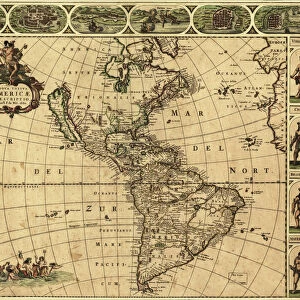
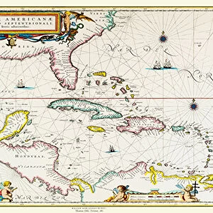
Photographic Print : Old Map of Brazil 1851 by John Tallis

![]()
Photo Prints from MapSeeker
Old Map of Brazil 1851 by John Tallis
A fine facimile artworked from an antique original map of Brazil, issued as part of the 1851 edition of John Tallis and Companys " The Illustrated Atlas and Modern History of the World"
Welcome to the Mapseeker Image library and enter an historic gateway to one of the largest on-line collections of Historic Maps, Nostalgic Views, Vista's and Panorama's from a World gone by.
Media ID 20347404
© Mapseeker Publishing Ltd
John Tallis John Tallis Map Tallis Map
11"x8.5" Photo Print
Step back in time with our Old Map of Brazil 1851 by John Tallis. This exquisite piece is a fine facsimile of an original map from the 1851 edition of John Tallis and Company's "The Illustrated Atlas and Modern History of the World". Meticulously arted from the antique original map of Brazil by John Tallis and John Rapkin from MapSeeker, this photographic print brings the historical detail and beauty of the past directly to your home or office. Add an air of timeless elegance to any space with this captivating piece of cartographic history.
Photo prints are produced on Kodak professional photo paper resulting in timeless and breath-taking prints which are also ideal for framing. The colors produced are rich and vivid, with accurate blacks and pristine whites, resulting in prints that are truly timeless and magnificent. Whether you're looking to display your prints in your home, office, or gallery, our range of photographic prints are sure to impress. Dimensions refers to the size of the paper in inches.
Our Photo Prints are in a large range of sizes and are printed on Archival Quality Paper for excellent colour reproduction and longevity. They are ideal for framing (our Framed Prints use these) at a reasonable cost. Alternatives include cheaper Poster Prints and higher quality Fine Art Paper, the choice of which is largely dependant on your budget.
Estimated Image Size (if not cropped) is 18.6cm x 27.9cm (7.3" x 11")
Estimated Product Size is 21.6cm x 27.9cm (8.5" x 11")
These are individually made so all sizes are approximate
Artwork printed orientated as per the preview above, with portrait (vertical) orientation to match the source image.
FEATURES IN THESE COLLECTIONS
> MapSeeker
> Maps of the Americas
> Maps of Central and South America
> Arts
> Artists
> T
> John Tallis
> Maps and Charts
> Related Images
> Maps and Charts
> World
> South America
> Brazil
> Maps
> South America
> Brazil
> Related Images
EDITORS COMMENTS
This print showcases an exquisite piece of cartographic history - the "Old Map of Brazil 1851" by John Tallis. Crafted as a fine facsimile artwork from an antique original map, this stunning depiction offers a glimpse into the rich heritage and geographical intricacies of Brazil during that era. Originally issued as part of the esteemed 1851 edition of John Tallis and Company's renowned publication, "The Illustrated Atlas and Modern History of the World" this map holds immense historical significance. Its intricate details and meticulous craftsmanship transport us back to a time when exploration was at its peak, unveiling uncharted territories with every stroke. As we delve into this old Brazilian map, we are transported through time to witness the vastness and diversity of this magnificent country. From lush rainforests to winding rivers, sprawling coastlines to majestic mountain ranges, every contour is painstakingly etched onto paper. John Tallis' expertise in cartography shines through in his masterful creation. The precision with which he captures not only geographic features but also cultural landmarks makes this work truly exceptional. It serves as a testament to his dedication towards presenting an accurate representation of Brazil's landscape while simultaneously celebrating its unique identity. This print allows us to appreciate both the artistry behind John Tallis' work and gain insight into Brazil's past. A true treasure for history enthusiasts and admirers alike, it invites us on a visual journey through time - reminding us that maps are not just navigational tools but windows
MADE IN THE USA
Safe Shipping with 30 Day Money Back Guarantee
FREE PERSONALISATION*
We are proud to offer a range of customisation features including Personalised Captions, Color Filters and Picture Zoom Tools
SECURE PAYMENTS
We happily accept a wide range of payment options so you can pay for the things you need in the way that is most convenient for you
* Options may vary by product and licensing agreement. Zoomed Pictures can be adjusted in the Cart.