Poster Print > Arts > Artists > T > John Tallis
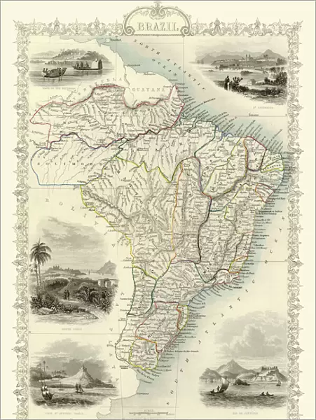
Poster Print : Old Map of Brazil 1851 by John Tallis


![]()
Poster Prints from MapSeeker
Old Map of Brazil 1851 by John Tallis
A fine facimile artworked from an antique original map of Brazil, issued as part of the 1851 edition of John Tallis and Companys " The Illustrated Atlas and Modern History of the World"
Welcome to the Mapseeker Image library and enter an historic gateway to one of the largest on-line collections of Historic Maps, Nostalgic Views, Vista's and Panorama's from a World gone by.
Media ID 20347404
© Mapseeker Publishing Ltd
John Tallis John Tallis Map Tallis Map
18x24 inch Poster Print
Step back in time with our Old Map of Brazil 1851 by John Tallis, an exquisite reproduction from the esteemed 1851 edition of John Tallis and Company's "The Illustrated Atlas and Modern History of the World". This intricately detailed poster print, featuring the brilliant work of John Tallis and John Rapkin from MapSeeker, showcases an antique map of Brazil with unparalleled accuracy and charm. Bring the history and geography of 19th century Brazil into your home or office with this beautiful and authentic-looking piece of art.
Poster prints are budget friendly enlarged prints in standard poster paper sizes. Printed on 150 gsm Matte Paper for a natural feel and supplied rolled in a tube. Great for framing and should last many years. To clean wipe with a microfiber, non-abrasive cloth or napkin. Our Archival Quality Photo Prints and Fine Art Paper Prints are printed on higher quality paper and the choice of which largely depends on your budget.
Poster prints are budget friendly enlarged prints in standard poster paper sizes (A0, A1, A2, A3 etc). Whilst poster paper is sometimes thinner and less durable than our other paper types, they are still ok for framing and should last many years. Our Archival Quality Photo Prints and Fine Art Paper Prints are printed on higher quality paper and the choice of which largely depends on your budget.
Estimated Product Size is 46.3cm x 61.6cm (18.2" x 24.3")
These are individually made so all sizes are approximate
Artwork printed orientated as per the preview above, with portrait (vertical) orientation to match the source image.
FEATURES IN THESE COLLECTIONS
> MapSeeker
> Maps of the Americas
> Maps of Central and South America
> Arts
> Artists
> T
> John Tallis
> Maps and Charts
> Related Images
> Maps and Charts
> World
> South America
> Brazil
> Maps
> South America
> Brazil
> Related Images
EDITORS COMMENTS
This print showcases an exquisite piece of cartographic history - the "Old Map of Brazil 1851" by John Tallis. Crafted as a fine facsimile artwork from an antique original map, this stunning depiction offers a glimpse into the rich heritage and geographical intricacies of Brazil during that era. Originally issued as part of the esteemed 1851 edition of John Tallis and Company's renowned publication, "The Illustrated Atlas and Modern History of the World" this map holds immense historical significance. Its intricate details and meticulous craftsmanship transport us back to a time when exploration was at its peak, unveiling uncharted territories with every stroke. As we delve into this old Brazilian map, we are transported through time to witness the vastness and diversity of this magnificent country. From lush rainforests to winding rivers, sprawling coastlines to majestic mountain ranges, every contour is painstakingly etched onto paper. John Tallis' expertise in cartography shines through in his masterful creation. The precision with which he captures not only geographic features but also cultural landmarks makes this work truly exceptional. It serves as a testament to his dedication towards presenting an accurate representation of Brazil's landscape while simultaneously celebrating its unique identity. This print allows us to appreciate both the artistry behind John Tallis' work and gain insight into Brazil's past. A true treasure for history enthusiasts and admirers alike, it invites us on a visual journey through time - reminding us that maps are not just navigational tools but windows
MADE IN THE USA
Safe Shipping with 30 Day Money Back Guarantee
FREE PERSONALISATION*
We are proud to offer a range of customisation features including Personalised Captions, Color Filters and Picture Zoom Tools
SECURE PAYMENTS
We happily accept a wide range of payment options so you can pay for the things you need in the way that is most convenient for you
* Options may vary by product and licensing agreement. Zoomed Pictures can be adjusted in the Cart.