Photographic Print > Europe > France > Canton > Landes
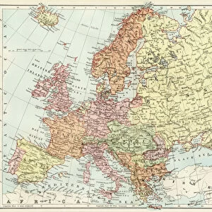
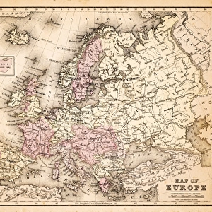
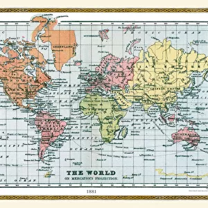
Photographic Print : Old Map of The World 1881


![]()
Photo Prints from MapSeeker
Old Map of The World 1881
Irish Land War (1879-1882); home rule movement led by Parnell. End of First Boer War (1880-1881). French establish a protectorate in Tunisia. President Garfield (USA) and Tsar Alexander II (Russia) assassinated. Serbia and Romania independent from the Ottoman Empire
Welcome to the Mapseeker Image library and enter an historic gateway to one of the largest on-line collections of Historic Maps, Nostalgic Views, Vista's and Panorama's from a World gone by.
Media ID 20347394
© Collins Bartholomew - Mapseeker Publishing Ltd
Map Of The World Old Map Of The World The World World Map
11"x8.5" Photo Print
Step back in time with our Old Map of The World 1881 print from the Media Storehouse collection. This captivating vintage map, sourced from MapSeeker, transports you back to a pivotal moment in history. The late 19th century was marked by significant events such as the Irish Land War led by Charles Stewart Parnell, the end of the First Boer War, and the French establishment of a protectorate in Tunisia. Add an intriguing touch to your home or office decor with this beautifully preserved piece of history. Each print is carefully crafted to preserve the original details and colors, ensuring a high-quality and authentic look. Bring history to life with Media Storehouse's Old Map of The World 1881 print.
Photo prints are produced on Kodak professional photo paper resulting in timeless and breath-taking prints which are also ideal for framing. The colors produced are rich and vivid, with accurate blacks and pristine whites, resulting in prints that are truly timeless and magnificent. Whether you're looking to display your prints in your home, office, or gallery, our range of photographic prints are sure to impress. Dimensions refers to the size of the paper in inches.
Our Photo Prints are in a large range of sizes and are printed on Archival Quality Paper for excellent colour reproduction and longevity. They are ideal for framing (our Framed Prints use these) at a reasonable cost. Alternatives include cheaper Poster Prints and higher quality Fine Art Paper, the choice of which is largely dependant on your budget.
Estimated Image Size (if not cropped) is 27.9cm x 18.6cm (11" x 7.3")
Estimated Product Size is 27.9cm x 21.6cm (11" x 8.5")
These are individually made so all sizes are approximate
Artwork printed orientated as per the preview above, with landscape (horizontal) orientation to match the source image.
FEATURES IN THESE COLLECTIONS
> MapSeeker
> Maps Showing the World
> Maps of The World by Year PORTFOLIO
> Africa
> Tunisia
> Related Images
> Europe
> France
> Canton
> Landes
> Europe
> Republic of Ireland
> Maps
> Europe
> Romania
> Related Images
EDITORS COMMENTS
This print showcases an extraordinary piece of history - an old map of the world from 1881. A visual time capsule, this map encapsulates a momentous era marked by significant global events and political shifts. The Irish Land War (1879-1882) and the home rule movement led by Parnell are depicted, reflecting Ireland's struggle for independence during this period. The aftermath of the First Boer War (1880-1881), which saw British forces clash with Boer settlers in South Africa, is also captured on this map. It serves as a reminder of the tensions that shaped colonial relations at the time. Additionally, it highlights France's establishment of a protectorate in Tunisia, signifying European powers' growing influence over African territories. Tragically, two prominent leaders met their untimely demise during this period - President Garfield of the United States and Tsar Alexander II of Russia were both assassinated. Their deaths left lasting impacts on their respective nations and reverberated across international politics. Furthermore, Serbia and Romania's emergence as independent states from under Ottoman Empire rule is illustrated here. This historical turning point reflects a wave of nationalism sweeping through Eastern Europe during the late 19th century. As we gaze upon this ancient cartographic treasure, we are transported back to a time when borders were shifting, empires were crumbling, and nations were fighting for self-determination. It reminds us that our world has always been in flux; constantly evolving through triumphs
MADE IN THE USA
Safe Shipping with 30 Day Money Back Guarantee
FREE PERSONALISATION*
We are proud to offer a range of customisation features including Personalised Captions, Color Filters and Picture Zoom Tools
SECURE PAYMENTS
We happily accept a wide range of payment options so you can pay for the things you need in the way that is most convenient for you
* Options may vary by product and licensing agreement. Zoomed Pictures can be adjusted in the Cart.