Photographic Print > Europe > United Kingdom > England > London > Towns > Welling
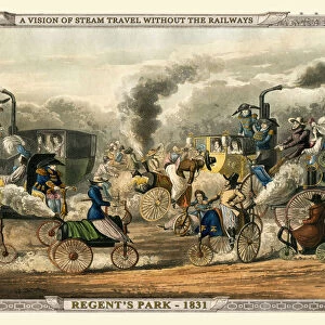
Photographic Print : Views on the London to Birmingham Railway - Railway Bridge at Rugby 1839


![]()
Photo Prints from MapSeeker
Views on the London to Birmingham Railway - Railway Bridge at Rugby 1839
A finely detailed facimile remastered in full colour from an antique original map of " Dumbartonshire" featured in A&C Blacks Atlas of 1847. Each Parish is numbered using an index table, colour rendition beautifully differentiating all of the Parishes. As well as principal roads, towns, villages and hamlets, these county maps of Scotland feature key battle sites marked with two crossed swords and the date of the battle. Dumbarton comes from the Scottish Gaelic Dšn Breatainn meaning " fort of the Britons".... Dumbartonshire County Council, set up under the Local Government (Scotland) Act 1889, adopted the spelling " Dunbartonshire" by 1914, a fact recognised by the Local Government (Scotland) Act 1947
Welcome to the Mapseeker Image library and enter an historic gateway to one of the largest on-line collections of Historic Maps, Nostalgic Views, Vista's and Panorama's from a World gone by.
Media ID 20346856
Birmingham To London Railway London To Birmingham Railway Railway View
11"x8.5" Photo Print
Step back in time with our exquisite Media Storehouse Photographic Prints featuring the "Views on the London to Birmingham Railway - Railway Bridge at Rugby 1839". This captivating image is a finely detailed facsimile, remastered in full colour from an antique original map published in A&C Black's Atlas of 1847. Each print showcases the rich history of transportation and engineering, with the intricate details of the bridge and the surrounding landscape brought to life. Perfect for railway enthusiasts, historians, or anyone who appreciates the beauty of the past, this print is a stunning addition to any home or office space. Order yours today and relive the magic of the Victorian era.
Photo prints are produced on Kodak professional photo paper resulting in timeless and breath-taking prints which are also ideal for framing. The colors produced are rich and vivid, with accurate blacks and pristine whites, resulting in prints that are truly timeless and magnificent. Whether you're looking to display your prints in your home, office, or gallery, our range of photographic prints are sure to impress. Dimensions refers to the size of the paper in inches.
Our Photo Prints are in a large range of sizes and are printed on Archival Quality Paper for excellent colour reproduction and longevity. They are ideal for framing (our Framed Prints use these) at a reasonable cost. Alternatives include cheaper Poster Prints and higher quality Fine Art Paper, the choice of which is largely dependant on your budget.
Estimated Image Size (if not cropped) is 27.9cm x 18.6cm (11" x 7.3")
Estimated Product Size is 27.9cm x 21.6cm (11" x 8.5")
These are individually made so all sizes are approximate
Artwork printed orientated as per the preview above, with landscape (horizontal) orientation to match the source image.
FEATURES IN THESE COLLECTIONS
> MapSeeker
> Old Views and Vistas
> 19th & 20th Century Railway Views
> Arts
> Photorealistic artworks
> Detailed art pieces
> Masterful detailing in art
> Europe
> United Kingdom
> England
> London
> Sport
> Rugby
> Europe
> United Kingdom
> England
> London
> Towns
> Welling
> Europe
> United Kingdom
> England
> London
> Transport
> Railway
> Europe
> United Kingdom
> Scotland
> Dumbarton
> Europe
> United Kingdom
> Scotland
> Maps
> Europe
> United Kingdom
> Scotland
> Railways
> Europe
> United Kingdom
> Scotland
> Strathclyde
> Dumbarton
> Historic
> Battles
> Related Images
> Maps and Charts
> Related Images
EDITORS COMMENTS
This beautifully remastered print captures the stunning Railway Bridge at Rugby in 1839, showcasing the remarkable views along the London to Birmingham Railway. The image is a finely detailed facsimile of an antique original map from A&C Blacks Atlas of 1847, specifically featuring Dumbartonshire. The map itself is a true work of art, with each parish numbered and colorfully differentiated, allowing for easy navigation and exploration. Additionally, it highlights principal roads, towns, villages, and hamlets throughout Scotland. Notably, key battle sites are marked by two crossed swords alongside their respective dates. Dumbartonshire holds historical significance as its name originates from the Scottish Gaelic term "Dún Breatainn" meaning "fort of the Britons". Over time, its spelling evolved to "Dunbartonshire" by 1914 under the administration of Dumbartonshire County Council. This change was officially recognized by the Local Government (Scotland) Act 1947. As you admire this print capturing a moment in railway history between London and Birmingham, take note that it does not pertain to any specific company or commercial use. Instead, it serves as a testament to both artistic craftsmanship and historical preservation.
MADE IN THE USA
Safe Shipping with 30 Day Money Back Guarantee
FREE PERSONALISATION*
We are proud to offer a range of customisation features including Personalised Captions, Color Filters and Picture Zoom Tools
SECURE PAYMENTS
We happily accept a wide range of payment options so you can pay for the things you need in the way that is most convenient for you
* Options may vary by product and licensing agreement. Zoomed Pictures can be adjusted in the Cart.