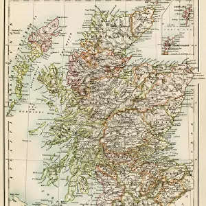
Photographic Print > North America > Cuba > Cuba Heritage Sites > Trinidad and the Valley de los Ingenios
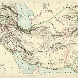
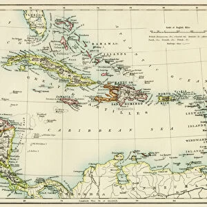
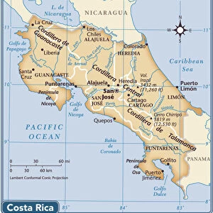
Photographic Print : Caribbean islands, 1870s


![]()
Photo Prints from North Wind
Caribbean islands, 1870s
Map of West Indies and the Caribbean Sea, 1800s.
Printed color lithograph
North Wind Picture Archives brings history to life with stock images and hand-colored illustrations
Media ID 5881795
© North Wind Picture Archives
1870s America Caribbean Caribbean Sea Central America Chart Cuba Florida Gulf Of Mexico Haiti Hispaniola Jamaica Panama Santo Domingo West Indies Antilles Bahamas Caribbean Islands Costa Rica El Salvador Grenada Honduras Leeward Islands Nicaragua Puerto Rico Trinidad Virgin Islands Windward Islands
10"x8" Photo Print
Discover the enchanting allure of the Caribbean islands in the 1870s with Media Storehouse's exquisite photographic print from North Wind Picture Archives. This stunning, color lithograph transports you back in time, offering a glimpse into the rich history and beauty of the West Indies and the Caribbean Sea as they appeared over a century ago. Immerse yourself in the vibrant hues and intricate details of this captivating map, a must-have for history enthusiasts, collectors, and those who appreciate the art of cartography. Experience the magic of the past with Media Storehouse's authentic, museum-quality prints.
Photo prints are produced on Kodak professional photo paper resulting in timeless and breath-taking prints which are also ideal for framing. The colors produced are rich and vivid, with accurate blacks and pristine whites, resulting in prints that are truly timeless and magnificent. Whether you're looking to display your prints in your home, office, or gallery, our range of photographic prints are sure to impress. Dimensions refers to the size of the paper in inches.
Our Photo Prints are in a large range of sizes and are printed on Archival Quality Paper for excellent colour reproduction and longevity. They are ideal for framing (our Framed Prints use these) at a reasonable cost. Alternatives include cheaper Poster Prints and higher quality Fine Art Paper, the choice of which is largely dependant on your budget.
Estimated Image Size (if not cropped) is 25.4cm x 18.3cm (10" x 7.2")
Estimated Product Size is 25.4cm x 20.3cm (10" x 8")
These are individually made so all sizes are approximate
Artwork printed orientated as per the preview above, with landscape (horizontal) orientation to match the source image.
FEATURES IN THESE COLLECTIONS
> North Wind Picture Archives
> Latin America:Caribbean
> North Wind Picture Archives
> Maps
> Maps and Charts
> Related Images
> Maps and Charts
> World
> North America
> The Bahamas
> Maps
> North America
> The Bahamas
> Related Images
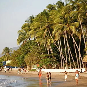
> North America
> Costa Rica
> Maps
> North America
> Costa Rica
> Related Images
> North America
> Cuba
> Cuba Heritage Sites
> Trinidad and the Valley de los Ingenios
> North America
> Cuba
> Maps
> North America
> Cuba
> Related Images
EDITORS COMMENTS
This vintage print takes us back to the Caribbean islands in the 1870s, showcasing a beautifully detailed map of the West Indies and the Caribbean Sea from the 1800s. The printed color lithograph exudes an air of heritage and tradition, transporting us to a bygone era rich with history. The illustration depicts a vast expanse encompassing Florida, Panama, Nicaragua, Haiti, Cuba, Bahamas, Honduras, Grenada, Trinidad and many more enchanting locations. It serves as a visual time capsule capturing the diverse tapestry of these tropical lands during that period. As we explore this intricate chart-like map adorned with vibrant colors and precise details, it becomes evident how crucial these islands were for trade routes between America and Central America. From Costa Rica to Puerto Rico and even extending into the Gulf of Mexico; this region played a significant role in shaping world history. With its depiction of Windward Islands like Santo Domingo alongside Leeward Islands such as Virgin Islands; this artwork offers an immersive experience into discovering lesser-known places like El Salvador or Hispaniola. It reminds us of their importance within the New World narrative. This North Wind Picture Archives print is not just an art piece but also an educational tool providing insights into geography while igniting our curiosity about past civilizations that thrived on these shores. Let's cherish this remarkable glimpse into our shared cultural heritage!
MADE IN THE USA
Safe Shipping with 30 Day Money Back Guarantee
FREE PERSONALISATION*
We are proud to offer a range of customisation features including Personalised Captions, Color Filters and Picture Zoom Tools
SECURE PAYMENTS
We happily accept a wide range of payment options so you can pay for the things you need in the way that is most convenient for you
* Options may vary by product and licensing agreement. Zoomed Pictures can be adjusted in the Cart.