Photographic Print > Europe > United Kingdom > England > Maps
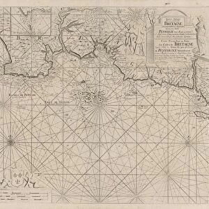
Photographic Print : Spanish Armadas route in 1588


![]()
Photo Prints from North Wind
Spanish Armadas route in 1588
Chart of the Spanish Armadas course, 1588.
Hand-colored engraving
North Wind Picture Archives brings history to life with stock images and hand-colored illustrations
Media ID 5881899
© North Wind Picture Archives
1500s 1580s 1588 16th Century Atlantic Ocean Battle Battle Ship British British Isles Chart Diagram Eire England English English Channel Europe European Great Britain Invade Invasion Ireland Island Maritime Military Naval Battle Navy North Sea Ocean Scot Land Sea Battle Sea Power Ship Spain Spanish Spanish Armada War Ship Armada
10"x10" Photo Print
Step back in time with Media Storehouse's exquisite photographic print of the Spanish Armada's historic route in 1588, courtesy of North Wind Picture Archives. This captivating hand-colored engraving offers a breathtaking glimpse into the past, detailing the intricate course of the legendary Spanish fleet as they sailed towards England. Add this stunning piece to your home or office decor and transport yourself to an era of adventure, exploration, and historical significance.
Photo prints are produced on Kodak professional photo paper resulting in timeless and breath-taking prints which are also ideal for framing. The colors produced are rich and vivid, with accurate blacks and pristine whites, resulting in prints that are truly timeless and magnificent. Whether you're looking to display your prints in your home, office, or gallery, our range of photographic prints are sure to impress. Dimensions refers to the size of the paper in inches.
Our Photo Prints are in a large range of sizes and are printed on Archival Quality Paper for excellent colour reproduction and longevity. They are ideal for framing (our Framed Prints use these) at a reasonable cost. Alternatives include cheaper Poster Prints and higher quality Fine Art Paper, the choice of which is largely dependant on your budget.
Estimated Image Size (if not cropped) is 25.4cm x 23.2cm (10" x 9.1")
Estimated Product Size is 25.4cm x 25.4cm (10" x 10")
These are individually made so all sizes are approximate
Artwork printed orientated as per the preview above, with landscape (horizontal) orientation to match the source image.
FEATURES IN THESE COLLECTIONS
> North Wind Picture Archives
> Maps
> Arts
> Artists
> O
> Oceanic Oceanic
> Europe
> France
> Canton
> Landes
> Europe
> Republic of Ireland
> Maps
> Europe
> Spain
> Related Images
> Europe
> United Kingdom
> England
> Maps
> Europe
> United Kingdom
> Maps
> Historic
> Battles
> Related Images
EDITORS COMMENTS
This hand-colored engraving showcases the Spanish Armada's historic route in 1588, offering a glimpse into one of Europe's most significant naval battles. The intricate illustration takes us back to the 16th century, where tensions between Spain and England were at their peak. With great attention to detail, this vintage print depicts the vastness of the Atlantic Ocean as it separates the British Isles from mainland Europe. The chart highlights key locations such as Great Britain, Ireland, and Scotland – all integral parts of this epic maritime conflict. As we follow the course meticulously outlined on this map, we can almost hear the clash of swords and cannons reverberating across these treacherous waters. This artwork not only captures a pivotal moment in history but also serves as a testament to both countries' rich naval heritage. It reminds us of how sea power played an essential role in shaping nations during this era. As we admire this piece, we are transported back in time to witness an intense battle for dominance unfold before our eyes. The Spanish Armada's formidable fleet is depicted with meticulous detail – each ship representing Spain's determination to invade England and assert its supremacy over European waters. With its vibrant colors and intricate design, this print offers a unique window into one of history's most legendary conflicts: the clash between two mighty naval powers that forever changed Europe's geopolitical landscape.
MADE IN THE USA
Safe Shipping with 30 Day Money Back Guarantee
FREE PERSONALISATION*
We are proud to offer a range of customisation features including Personalised Captions, Color Filters and Picture Zoom Tools
SECURE PAYMENTS
We happily accept a wide range of payment options so you can pay for the things you need in the way that is most convenient for you
* Options may vary by product and licensing agreement. Zoomed Pictures can be adjusted in the Cart.