Photographic Print > Africa > Egypt > Maps
Photographic Print : Homeric cosmogony


![]()
Photo Prints from Science Photo Library
Homeric cosmogony
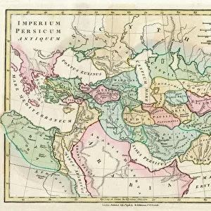
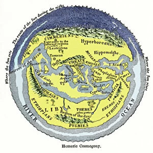
Homeric cosmogony. Map of the Earth based on the myths and knowledge of the Ancient Greeks at the time of Homer (1st or 2nd millennium BC). The map shows a flat Earth centred on Greece and the Mediterranean Sea, surrounded by a River Ocean. At night, the Sun passes from west to east behind a range of high mountains in the north ( region of the night ). To the south in North Africa, is the region of the day. Other mythological references include the Elysian Fields, the island of the Cyclops, and the entrance to hell. Civilisations (historical and mythological) marked here include: Ethiopians, Libyans, Pygmies, Egyptians, Amazons, Phoenicians, Hyperboreans and Cimmerians. Places include: Thebes, Sparta, Troy, Thrace, Crete and Cyprus. Artwork from Pioneers of Science (Oliver Lodge, 1893)
Science Photo Library features Science and Medical images including photos and illustrations
Media ID 6349031
© SHEILA TERRY/SCIENCE PHOTO LIBRARY
1893 Africa African Ancient Ancient Greece Antiquity Cartography Circle Circular Classical Cosmogonical Cosmogony Cosmological Cosmology Crete Cyclops Cyprus Egypt Egyptians Ethiopia Greece Greek Italy Land Libya Mapping Maps Mediterranean Myth Mythical Mythological Mythology Myths Night Old World Oliver Lodge Pioneers Of Science Religion Round Underworld World Amazons Ancient Greeks Ancient World Elysian Fields Ethiopians Flat Earth Hades Homer Homeric Libyans Phoenicia Phoenicians Pygmies Sparta Thebes Thrace Troy
10"x10" Photo Print
Discover the captivating world of ancient mythology and scientific exploration with our Media Storehouse range of Photographic Prints. This striking image, "Homeric Cosmogony," transports you back in time to the intriguing maps and myths of the Ancient Greeks, as depicted in this mesmerizing representation of their understanding of the Earth during the era of Homer (1st or 2nd millennium BC). Based on the Science Photo Library's extensive collection, this photographic print is not just a beautiful addition to any space, but also a fascinating insight into the rich history of human knowledge and the power of myth. Elevate your home or office décor with this thought-provoking and visually stunning print.
Photo prints are produced on Kodak professional photo paper resulting in timeless and breath-taking prints which are also ideal for framing. The colors produced are rich and vivid, with accurate blacks and pristine whites, resulting in prints that are truly timeless and magnificent. Whether you're looking to display your prints in your home, office, or gallery, our range of photographic prints are sure to impress. Dimensions refers to the size of the paper in inches.
Our Photo Prints are in a large range of sizes and are printed on Archival Quality Paper for excellent colour reproduction and longevity. They are ideal for framing (our Framed Prints use these) at a reasonable cost. Alternatives include cheaper Poster Prints and higher quality Fine Art Paper, the choice of which is largely dependant on your budget.
Estimated Product Size is 25.4cm x 25.4cm (10" x 10")
These are individually made so all sizes are approximate
Artwork printed orientated as per the preview above, with landscape (horizontal) or portrait (vertical) orientation to match the source image.
FEATURES IN THESE COLLECTIONS
> Africa
> Egypt
> Related Images
> Africa
> Ethiopia (Abyssinia)
> Related Images
> Africa
> Ethiopia
> Related Images
> Africa
> Libya
> Related Images
> Africa
> Related Images
> Africa
> South Africa
> Maps
> Africa
> South Africa
> Related Images
> Animals
> Mammals
> Muridae
> Pygmy Mouse
EDITORS COMMENTS
This print showcases the Homeric cosmogony, a map of the Earth based on the myths and knowledge of the Ancient Greeks during Homer's time. Created in the 1st or 2nd millennium BC, this ancient depiction portrays a flat Earth with Greece and the Mediterranean Sea at its center, encircled by a majestic River Ocean. As night falls, the Sun gracefully glides from west to east behind towering mountains located in the north, representing the region of darkness. In contrast, towards North Africa lies the realm of daylight. The map also features various mythological references that transport us into an enchanting world. From mythical locations like Elysian Fields and Cyclops Island to entrances leading to hell, it beautifully weaves together elements from Greek mythology. Additionally, civilizations both historical and mythological are marked across this intricate artwork: Ethiopians, Libyans, Pygmies, Egyptians, Amazons, Phoenicians Hyperboreans, and Cimmerians. Notable places such as Thebes, Sparta, Troy, Thrace Crete, and Cyprus are depicted within this mesmerizing illustration. This masterpiece hails from "Pioneers of Science" (Oliver Lodge), published in 1893 - an era when cartography was still evolving but held immense significance in understanding our world's history and culture. Through this image captured by Science Photo Library, the viewer is transported back to ancient times where mythology intertwined with reality; where imagination shaped beliefs about our planet's origins and structure. This remarkable piece serves as a testament to humanity's enduring curiosity about our place in the cosmos throughout different epochs.
MADE IN THE USA
Safe Shipping with 30 Day Money Back Guarantee
FREE PERSONALISATION*
We are proud to offer a range of customisation features including Personalised Captions, Color Filters and Picture Zoom Tools
SECURE PAYMENTS
We happily accept a wide range of payment options so you can pay for the things you need in the way that is most convenient for you
* Options may vary by product and licensing agreement. Zoomed Pictures can be adjusted in the Cart.