Pillow > Arts > Artists > F > Giulio Ferrario
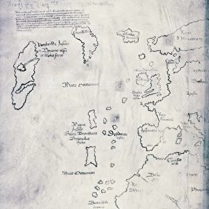
Pillow : Map of the European colonies in the New World (North and Central America), 1846. Handcoloured copperplate engraving from Giulio Ferrario's Ancient and Modern Costumes of all the Peoples of the World, 1837
, 1846. Handcoloured copperplate engraving from Giulio Ferrario's Ancient and Modern Costumes of all the Peoples of the World, 1837")
, 1846. Handcoloured copperplate engraving from Giulio Ferrario's Ancient and Modern Costumes of all the Peoples of the World, 1837")

![]()
Home Decor from Fine Art Finder
Map of the European colonies in the New World (North and Central America), 1846. Handcoloured copperplate engraving from Giulio Ferrario's Ancient and Modern Costumes of all the Peoples of the World, 1837
FLO4621821 Map of the European colonies in the New World (North and Central America), 1846. Handcoloured copperplate engraving from Giulio Ferrario's Ancient and Modern Costumes of all the Peoples of the World, 1837.; (add.info.: Map of the European colonies in the New World (North and Central America), 1846. Handcoloured copperplate engraving from Giulio Ferrario's Ancient and Modern Costumes of all the Peoples of the World, 1837.); © Florilegius
Media ID 38154316
© © Florilegius / Bridgeman Images
Amerique Centrale Amerique Du Nord Carte Geographique Central America Danemark Danish Denmark Etats Unis Etats Unis Damèrique Geographie Greenland Groenland Pays Nordiques Geographical Map
18"x18" (46x46cm) Pillow
18"x18" (46x46cm) Faux Suede Pillow with a plush soft feel. Your choice of image fills the front, with a stone colored faux suede back. Flat sewn concealed white zip.
Accessorise your space with decorative, soft pillows
Estimated Product Size is 45.7cm x 45.7cm (18" x 18")
These are individually made so all sizes are approximate
Artwork printed orientated as per the preview above, with landscape (horizontal) or portrait (vertical) orientation to match the source image.
FEATURES IN THESE COLLECTIONS
> Fine Art Finder
> Artists
> Alinari Fratelli
> Arts
> Artists
> F
> Giulio Ferrario
> Europe
> Denmark
> Related Images
> Maps and Charts
> Early Maps
> Maps and Charts
> World
> North America
> Greenland
> Maps
EDITORS COMMENTS
This stunning handcoloured copperplate engraving from Giulio Ferrario's Ancient and Modern Costumes of all the Peoples of the World, 1837, showcases a detailed map of the European colonies in the New World (North and Central America) dating back to 1846. The intricate design and vibrant colors bring to life the historical significance of this map, providing a glimpse into the colonial powers that once dominated these regions.
As we study this map, we are transported back to a time when European nations such as Spain, France, England, and Portugal were vying for control over vast territories in North and Central America. The borders delineating each colony tell a story of conquests, alliances, and conflicts that shaped the course of history in these lands.
From Greenland under Danish rule to the United States emerging as a dominant force in North America, every detail on this map is a testament to the complex geopolitical landscape of the 19th century. It serves as a reminder of how different cultures intersected and clashed during an era marked by exploration and colonization.
This print is not just a geographical representation but also a visual narrative of power dynamics and cultural exchange between Europe and the Americas. It stands as both an educational tool for understanding past events and an artistic masterpiece worth admiring for its craftsmanship.
MADE IN THE USA
Safe Shipping with 30 Day Money Back Guarantee
FREE PERSONALISATION*
We are proud to offer a range of customisation features including Personalised Captions, Color Filters and Picture Zoom Tools
SECURE PAYMENTS
We happily accept a wide range of payment options so you can pay for the things you need in the way that is most convenient for you
* Options may vary by product and licensing agreement. Zoomed Pictures can be adjusted in the Cart.