Poster Print > Arts > Artists > L > Antoine Lafrery
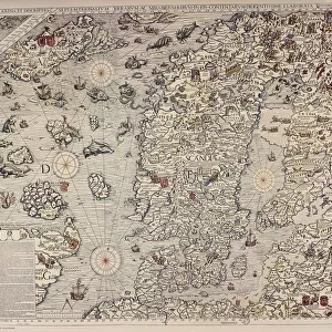
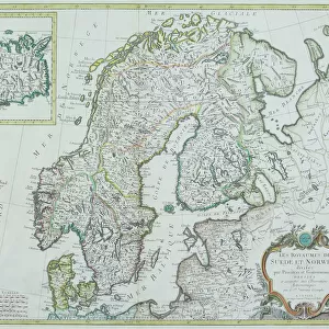
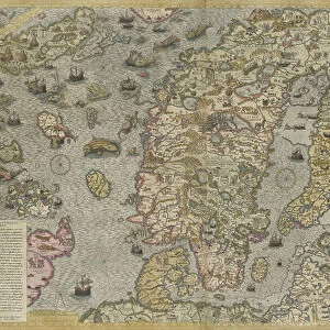
Poster Print : Map of the Sea (Carta marina) by Olaus Magnus (1490-1557), 1572 (engraving)
 by Olaus Magnus (1490-1557), 1572 (engraving)")


![]()
Poster Prints from Fine Art Finder
Map of the Sea (Carta marina) by Olaus Magnus (1490-1557), 1572 (engraving)
7393830 Map of the Sea (Carta marina) by Olaus Magnus (1490-1557), 1572 (engraving) by Lafrery, Antoine (1512-77); Private Collection; (add.info.: The Carta marina of the Swedish geographer and historian Olaus Magnus (1490-1557) is one of the earliest accurate cartographic depictions of the Scandinavian peninsula. This is the second edition of this map, published by Antoine Lafréry in 1572.)
Media ID 32103180
© Bridgeman Images
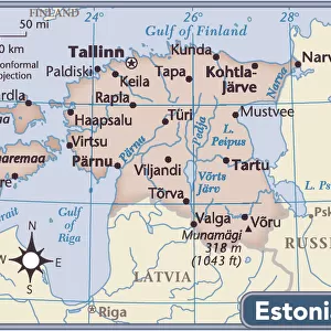
Baltics Coast Line Compass Compass Card Compasses Estonia Estonian Estonians Fantastic Animal Fantastic Creature Fantastic Creatures Finland Finnish Latvia Latvian Latvians Lithuania Lithuanian Lithuanians Multi Function Tool Mythical Animal Mythical Beast Mythical Creature Mythical Creatures North Sea Norway Norway Norwegian Norwegian Norwegians Sverige Sweden Toolkit Work Tools World Map C16h Geographer Seawater
18x24 inch Poster Print
Discover the wonders of the ancient world with our exquisite Map of the Sea (Carta marina) print from Media Storehouse. This stunning engraving, created by Olaus Magnus in 1572 and masterfully engraved by Antoine Lafrery, offers a captivating glimpse into the cartography of the 16th century. Depicting the known world at the time, this intricately detailed map is a testament to the curiosity and exploration of the past. Bring history into your home or office with this beautiful and authentic work of art from Fine Art Finder.
Poster prints are budget friendly enlarged prints in standard poster paper sizes. Printed on 150 gsm Matte Paper for a natural feel and supplied rolled in a tube. Great for framing and should last many years. To clean wipe with a microfiber, non-abrasive cloth or napkin. Our Archival Quality Photo Prints and Fine Art Paper Prints are printed on higher quality paper and the choice of which largely depends on your budget.
Poster prints are budget friendly enlarged prints in standard poster paper sizes (A0, A1, A2, A3 etc). Whilst poster paper is sometimes thinner and less durable than our other paper types, they are still ok for framing and should last many years. Our Archival Quality Photo Prints and Fine Art Paper Prints are printed on higher quality paper and the choice of which largely depends on your budget.
Estimated Product Size is 61.6cm x 46.3cm (24.3" x 18.2")
These are individually made so all sizes are approximate
Artwork printed orientated as per the preview above, with landscape (horizontal) orientation to match the source image.
FEATURES IN THESE COLLECTIONS
> Fine Art Finder
> Artists
> Antoine Lafrery
> Fine Art Finder
> Artists
> Giandomenico (1727-1804) Tiepolo
> Animals
> Mammals
> Muridae
> Magnus
> Arts
> Artists
> L
> Antoine Lafrery
> Europe
> Estonia
> Related Images
> Europe
> Finland
> Related Images
> Europe
> Latvia
> Related Images
EDITORS COMMENTS
This print showcases the "Map of the Sea (Carta marina) by Olaus Magnus" an exquisite engraving created by Antoine Lafréry in 1572. The original map, crafted by Swedish geographer and historian Olaus Magnus between 1527 and 1539, is considered one of the earliest accurate cartographic depictions of the Scandinavian peninsula. The second edition of this remarkable map, published by Lafréry, beautifully captures the intricate details and vibrant colors that bring to life a world filled with mythical creatures and fantastic beasts. As you explore this mesmerizing artwork, your eyes will be drawn to a compass card at its center, symbolizing navigation tools used during that era. With its coastal scenes depicting shorelines and ships sailing across seas like the North Sea, this map provides valuable insights into maritime exploration during the sixteenth century. It encompasses various European regions such as Finland, Scandinavia (including Sweden), Norway, Estonia, and even parts of modern-day Baltic countries. This print from Bridgeman Images allows us to appreciate not only the artistic beauty but also the historical significance embedded within this masterpiece. Whether you are fascinated by cartography or simply intrigued by ancient maps revealing Europe's past geography and seafaring traditions, "Map of the Sea (Carta marina) by Olaus Magnus" is sure to captivate your imagination.
MADE IN THE USA
Safe Shipping with 30 Day Money Back Guarantee
FREE PERSONALISATION*
We are proud to offer a range of customisation features including Personalised Captions, Color Filters and Picture Zoom Tools
SECURE PAYMENTS
We happily accept a wide range of payment options so you can pay for the things you need in the way that is most convenient for you
* Options may vary by product and licensing agreement. Zoomed Pictures can be adjusted in the Cart.