Poster Print > Asia > Georgia > Maps
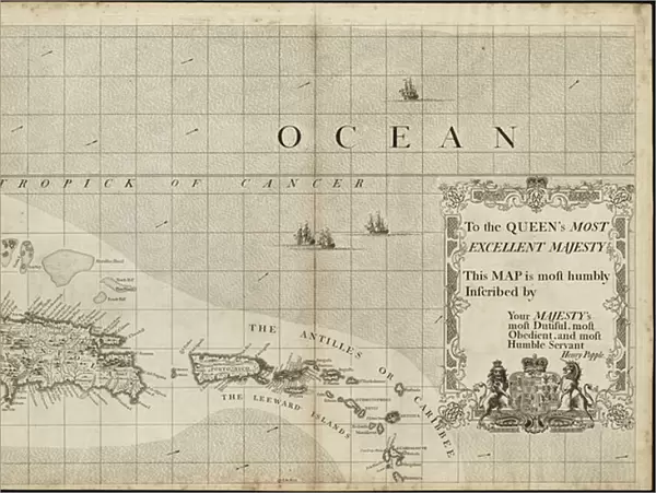
Poster Print : A map of the British Empire in America with the French and Spanish settlements adjacent thereto, 1733 (engraving)
")

![]()
Poster Prints from Fine Art Finder
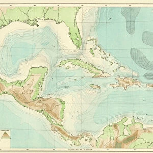
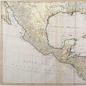
A map of the British Empire in America with the French and Spanish settlements adjacent thereto, 1733 (engraving)
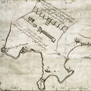
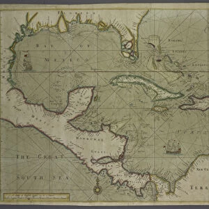
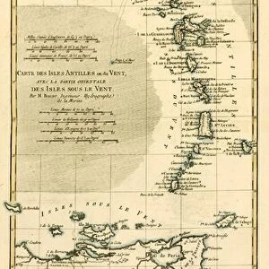
5648407 A map of the British Empire in America with the French and Spanish settlements adjacent thereto, 1733 (engraving) by Popple, Henry (d.1743); 49x69 cm; Boston Public Library, Boston, Massachusetts, USA
Media ID 25172336
© Bridgeman Images
Antilles Caribbean Carribean Colonies Islands Mapping New World Tropical Virgin Islands West Indian West Indies Vintage Map
18x24 inch Poster Print
Discover the historical depth of the past with our exquisite Map of the British Empire in America, dating back to 1733. This captivating poster print, featuring an engraving by Henry Popple, offers a fascinating glimpse into the geopolitical landscape of the Americas during that era. The intricate details of the British Empire's territories, alongside French and Spanish settlements, are beautifully rendered, making it an essential addition to any history or cartography enthusiast's collection. Bring a piece of the past into your home or office with our high-quality poster prints from Media Storehouse.
Poster prints are budget friendly enlarged prints in standard poster paper sizes. Printed on 150 gsm Matte Paper for a natural feel and supplied rolled in a tube. Great for framing and should last many years. To clean wipe with a microfiber, non-abrasive cloth or napkin. Our Archival Quality Photo Prints and Fine Art Paper Prints are printed on higher quality paper and the choice of which largely depends on your budget.
Poster prints are budget friendly enlarged prints in standard poster paper sizes (A0, A1, A2, A3 etc). Whilst poster paper is sometimes thinner and less durable than our other paper types, they are still ok for framing and should last many years. Our Archival Quality Photo Prints and Fine Art Paper Prints are printed on higher quality paper and the choice of which largely depends on your budget.
Estimated Product Size is 61.6cm x 46.3cm (24.3" x 18.2")
These are individually made so all sizes are approximate
Artwork printed orientated as per the preview above, with landscape (horizontal) orientation to match the source image.
FEATURES IN THESE COLLECTIONS
> Fine Art Finder
> Artists
> Henry Popple
> Fine Art Finder
> Artists
> Pellegrino (1617-1640) Piola
> Asia
> Georgia
> Related Images
> Europe
> Spain
> Related Images
> Historic
> Colonial America illustrations
> American colonies
> Historic
> Colonial America illustrations
> Colonial America
> Maps and Charts
> British Empire Maps
EDITORS COMMENTS
This engraving, titled "A map of the British Empire in America with the French and Spanish settlements adjacent thereto, 1733" takes us back to a time when cartography was both an art form and a tool for exploration. Created by Henry Popple, this vintage map measures 49x69 cm and is housed at the Boston Public Library in Massachusetts. The intricate details of this map transport us to the colonial era, where we can observe the vastness of the British Empire's holdings in America. From the West Indies to the Virgin Islands, every island and colony is meticulously depicted, showcasing Britain's dominance over these territories. As we delve into this historical piece, we are reminded of how maps were not only used for navigation but also as symbols of power and control. The careful delineation of borders between British, French, and Spanish settlements highlights ongoing territorial disputes during that period. With its tropical aesthetic and Georgian style elements, this print offers a glimpse into a world vastly different from our own. It serves as a reminder of how far we have come since those times while also sparking curiosity about what life was like during that era. Whether you're an avid history enthusiast or simply appreciate fine art prints like this one from Bridgeman Images' collection on Fine Art Finder, this mesmerizing engraving will undoubtedly transport you back in time to explore the intricacies of early American colonization.
MADE IN THE USA
Safe Shipping with 30 Day Money Back Guarantee
FREE PERSONALISATION*
We are proud to offer a range of customisation features including Personalised Captions, Color Filters and Picture Zoom Tools
SECURE PAYMENTS
We happily accept a wide range of payment options so you can pay for the things you need in the way that is most convenient for you
* Options may vary by product and licensing agreement. Zoomed Pictures can be adjusted in the Cart.