Poster Print > Asia > Japan > Maps
Poster Print : Plan of the Battle of Sekigahara, October 21st 1600, 1903. Creator: Unknown


![]()
Poster Prints from Heritage Images
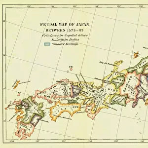
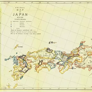
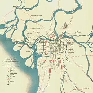
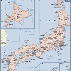
Plan of the Battle of Sekigahara, October 21st 1600, 1903. Creator: Unknown
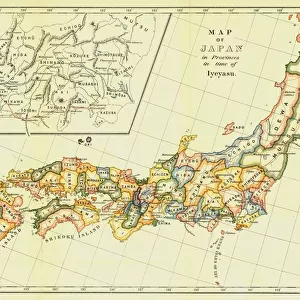
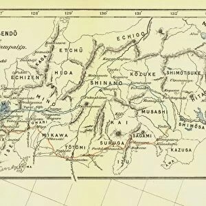
Plan of the Battle of Sekigahara, October 21st 1600, 1903. On October 21, 1600, troops were deployed on the Nakasendo mountain pass for the Battle of Sekigahara. Both sides had forces that did not arrive in time for the conflict. From A History of Japan during the century of early foreign intercourse (1542-1651) by James Murdoch, M.A. and Isoh Yamagata. [Kobe, Japan, 1903]
Heritage Images features heritage image collections
Media ID 19667067
© The Print Collector/Heritage Images
Cartography Division Edo Bakufu Government Ieyasu Ieyasu Tokugawa Isoh Isoh Yamagata Iyeyasu James Murdoch Map Making Mountain Pass Murdoch Murdoch James Nakasendo Nikko Tosho Gu Orange Orange Colour Pass Route Strategic Strategy Tokaido Tokaido Japan Tokugawa Tokugawa Bakufu Tokugawa Ieyasu Tokugawa Shogunate Yamagata Yamagata Isoh Deploying
20x30 inch Poster Print
Step back in time with our vintage Plan of the Battle of Sekigahara poster print from Media Storehouse. This intriguing map, created in 1903, depicts the strategic deployment of troops during the historic Battle of Sekigahara on October 21, 1600. Held on the Nakasendo mountain pass, this decisive battle marked the end of the Sengoku period and the beginning of the Edo period in Japan. Add an element of history and intrigue to your space with this beautifully detailed and captivating poster, sourced from Heritage Images and available now at Media Storehouse.
Poster prints are budget friendly enlarged prints in standard poster paper sizes. Printed on 150 gsm Matte Paper for a natural feel and supplied rolled in a tube. Great for framing and should last many years. To clean wipe with a microfiber, non-abrasive cloth or napkin. Our Archival Quality Photo Prints and Fine Art Paper Prints are printed on higher quality paper and the choice of which largely depends on your budget.
Poster prints are budget friendly enlarged prints in standard poster paper sizes (A0, A1, A2, A3 etc). Whilst poster paper is sometimes thinner and less durable than our other paper types, they are still ok for framing and should last many years. Our Archival Quality Photo Prints and Fine Art Paper Prints are printed on higher quality paper and the choice of which largely depends on your budget.
Estimated Product Size is 76.8cm x 51.4cm (30.2" x 20.2")
These are individually made so all sizes are approximate
Artwork printed orientated as per the preview above, with landscape (horizontal) or portrait (vertical) orientation to match the source image.
FEATURES IN THESE COLLECTIONS
> Asia
> Japan
> Related Images
> Historic
> Battles
> Related Images
> Maps and Charts
> Early Maps
> Maps and Charts
> Related Images
EDITORS COMMENTS
This print showcases the "Plan of the Battle of Sekigahara" that took place on October 21st, 1600. The image, created in 1903 by an unknown artist, offers a glimpse into this significant historical event during Japan's Edo period. The battle was fought on the Nakasendo mountain pass, as depicted in vibrant colors and intricate cartography. It highlights the strategic deployment of troops from both sides who arrived late to join the conflict. This detail adds depth to our understanding of the complexities surrounding this battle. As we delve into Japanese history through this print, we are transported back to a time when war and warfare played a crucial role in shaping nations. The map not only provides geographical features but also serves as a visual representation of military strategy employed by Tokugawa Ieyasu and his forces. Through its careful composition and attention to detail, this photograph allows us to appreciate the artistry involved in map-making during the seventeenth century. It is evident that great effort was put into creating an accurate depiction of this historic location. Overall, this print invites us to explore Japan's rich past while reminding us of the significance battles like Sekigahara had on shaping its future under Tokugawa Shogunate rule.
MADE IN THE USA
Safe Shipping with 30 Day Money Back Guarantee
FREE PERSONALISATION*
We are proud to offer a range of customisation features including Personalised Captions, Color Filters and Picture Zoom Tools
SECURE PAYMENTS
We happily accept a wide range of payment options so you can pay for the things you need in the way that is most convenient for you
* Options may vary by product and licensing agreement. Zoomed Pictures can be adjusted in the Cart.