Poster Print > Europe > France > Canton > Landes
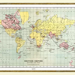
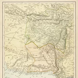
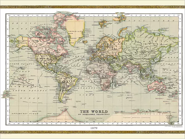
Poster Print : Old Map of The World 1879


![]()
Poster Prints from MapSeeker
Old Map of The World 1879
THE WORLD THAT WAS 1878 - Irish Land War (1879-1882). Second Afghan War gives Britain control over Afghanistan. Dual Alliance between Germany and Austria-Hungary. Anglo-Zulu War. War of the Pacific, Chile against Bolivia and Peru (1879-1884)
Welcome to the Mapseeker Image library and enter an historic gateway to one of the largest on-line collections of Historic Maps, Nostalgic Views, Vista's and Panorama's from a World gone by.
Media ID 20347376
© Collins Bartholomew - Mapseeker Publishing Ltd
Map Of The World Old Map Of The World The World World Map
18x24 inch Poster Print
Step back in time with our Old Map of The World 1879 from MapSeeker, available in the Media Storehouse range of Poster Prints. This captivating vintage map offers a glimpse into a bygone era, depicting the world as it was known in 1879. Witness the geopolitical landscape of the time with intriguing details, including the Irish Land War, the Second Afghan War, and the Dual Alliance between Germany and Austria-Hungary. Add this historical masterpiece to your home or office to spark curiosity and inspire conversation. Each print is meticulously produced using high-quality materials for vibrant colors and long-lasting durability.
Poster prints are budget friendly enlarged prints in standard poster paper sizes. Printed on 150 gsm Matte Paper for a natural feel and supplied rolled in a tube. Great for framing and should last many years. To clean wipe with a microfiber, non-abrasive cloth or napkin. Our Archival Quality Photo Prints and Fine Art Paper Prints are printed on higher quality paper and the choice of which largely depends on your budget.
Poster prints are budget friendly enlarged prints in standard poster paper sizes (A0, A1, A2, A3 etc). Whilst poster paper is sometimes thinner and less durable than our other paper types, they are still ok for framing and should last many years. Our Archival Quality Photo Prints and Fine Art Paper Prints are printed on higher quality paper and the choice of which largely depends on your budget.
Estimated Product Size is 61.6cm x 46.3cm (24.3" x 18.2")
These are individually made so all sizes are approximate
Artwork printed orientated as per the preview above, with landscape (horizontal) orientation to match the source image.
FEATURES IN THESE COLLECTIONS
> MapSeeker
> Maps Showing the World
> Maps of The World by Year PORTFOLIO
> Asia
> Afghanistan
> Maps
> Europe
> Austria
> Related Images
> Europe
> France
> Canton
> Landes
> Europe
> Hungary
> Related Images
> Europe
> Republic of Ireland
> Maps
EDITORS COMMENTS
This print showcases an exquisite piece of history, the "Old Map of The World 1879". Stepping into a time capsule, we are transported back to an era brimming with significant global events and shifting power dynamics. As our eyes wander across the intricate details etched on this vintage map, we are reminded of the tumultuous times that defined 1878. The Irish Land War (1879-1882) takes center stage in this snapshot of history, as Ireland's struggle for land rights reverberated throughout the British Isles. Meanwhile, the Second Afghan War unfolds before us, marking Britain's strategic conquest over Afghanistan and solidifying its control over this region. Further exploring this remarkable map reveals another pivotal moment: the Dual Alliance between Germany and Austria-Hungary. This alliance would shape European politics for years to come, setting the stage for future conflicts and alliances. As our gaze shifts towards other corners of this world map, we encounter additional historical milestones. The Anglo-Zulu War captures our attention—a clash between colonial powers and indigenous peoples that left an indelible mark on South African history. Lastly, we glimpse at a lesser-known but equally significant conflict—the War of the Pacific—where Chile clashed against Bolivia and Peru from 1879 to 1884. This territorial dispute reshaped borders in South America forever. Intriguingly layered with tales from around the globe, this old map serves as a tangible reminder of how interconnected our world has always been—an artifact
MADE IN THE USA
Safe Shipping with 30 Day Money Back Guarantee
FREE PERSONALISATION*
We are proud to offer a range of customisation features including Personalised Captions, Color Filters and Picture Zoom Tools
SECURE PAYMENTS
We happily accept a wide range of payment options so you can pay for the things you need in the way that is most convenient for you
* Options may vary by product and licensing agreement. Zoomed Pictures can be adjusted in the Cart.