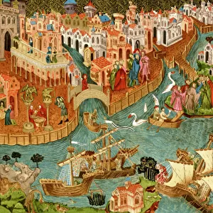
Poster Print > Europe > Italy > Veneto > Venice
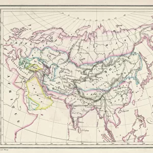
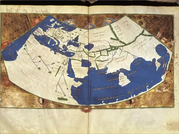
Poster Print : PTOLEMY, Claudius Ptolemaeus ( c. AD 100 - c


![]()
Poster Prints from Mary Evans Picture Library
PTOLEMY, Claudius Ptolemaeus ( c. AD 100 - c
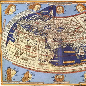
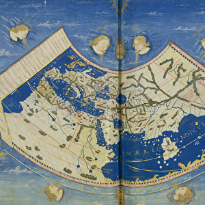
" PTOLEMY, Claudius Ptolemaeus ( c. AD 100 - c. AD 170). Egyptian astronomer, mathematician and geographer. Map of the Ancient World. From the work " Ptolomeus Geographicorum Libri". ITALY. Venice. Biblioteca nazionale marciana (St. Marks Library)."
Mary Evans Picture Library makes available wonderful images created for people to enjoy over the centuries
Media ID 8269213
© Mary Evans Picture Library 2015 - https://copyrighthub.org/s0/hub1/creation/maryevans/MaryEvansPictureID/10685897
Astronomer Biblioteca Claudius Geographer Libri Marciana Mathematician Nazionale Ptolemaeus Ptolemy Venice
18x24 inch Poster Print
Discover the rich history of ancient geography with our stunning Ptolemy Poster Prints from Media Storehouse. Featuring an iconic image of Claudius Ptolemaeus, also known as Ptolemy, these prints showcase his famous Map of the Ancient World. As a renowned Egyptian astronomer, mathematician, and geographer, Ptolemy's work "Geographika" significantly influenced the way we understand the world during antiquity. Our high-quality poster prints, sourced from the extensive collection at Mary Evans Prints Online, are perfect for adding a touch of history and culture to any room. Bring the wisdom of the past into your home or office with a Ptolemy Poster Print from Media Storehouse.
Poster prints are budget friendly enlarged prints in standard poster paper sizes. Printed on 150 gsm Matte Paper for a natural feel and supplied rolled in a tube. Great for framing and should last many years. To clean wipe with a microfiber, non-abrasive cloth or napkin. Our Archival Quality Photo Prints and Fine Art Paper Prints are printed on higher quality paper and the choice of which largely depends on your budget.
Poster prints are budget friendly enlarged prints in standard poster paper sizes (A0, A1, A2, A3 etc). Whilst poster paper is sometimes thinner and less durable than our other paper types, they are still ok for framing and should last many years. Our Archival Quality Photo Prints and Fine Art Paper Prints are printed on higher quality paper and the choice of which largely depends on your budget.
Estimated Product Size is 61.6cm x 46.3cm (24.3" x 18.2")
These are individually made so all sizes are approximate
Artwork printed orientated as per the preview above, with landscape (horizontal) orientation to match the source image.
FEATURES IN THESE COLLECTIONS
> Africa
> Egypt
> Related Images
> Europe
> Italy
> Related Images
> Europe
> Italy
> Veneto
> Venice
> Maps and Charts
> Early Maps
> Maps and Charts
> Italy
> Maps and Charts
> Related Images
> Maps and Charts
> World
MADE IN THE USA
Safe Shipping with 30 Day Money Back Guarantee
FREE PERSONALISATION*
We are proud to offer a range of customisation features including Personalised Captions, Color Filters and Picture Zoom Tools
SECURE PAYMENTS
We happily accept a wide range of payment options so you can pay for the things you need in the way that is most convenient for you
* Options may vary by product and licensing agreement. Zoomed Pictures can be adjusted in the Cart.