Poster Print > Arts > Artists > H > Franz Hogenberg
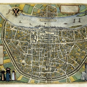
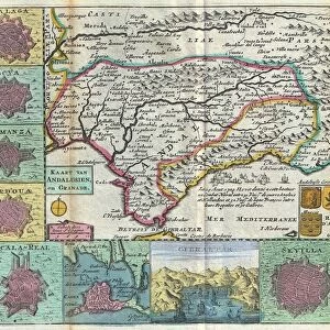
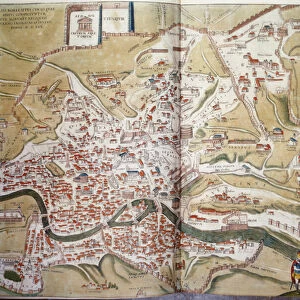
Poster Print : Spain. Castile and Leon. Burgos. Map, 1576 at Civitates


![]()
Poster Prints from Mary Evans Picture Library
Spain. Castile and Leon. Burgos. Map, 1576 at Civitates
Spain. Castile and Leon. Burgos. Map, 1576 at Civitates Orbis Terrarum by Georg Braun (1541-1622) and Franz Hogenberg (1536-1590). Salamanca University Library
Mary Evans Picture Library makes available wonderful images created for people to enjoy over the centuries
Media ID 14406726
© Thaliastock / Mary Evans
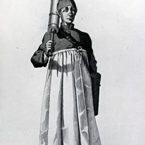
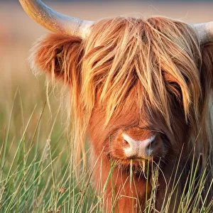
1576 Burgos Cartography Castile Castilia Castilian Cattle Civitates Crop Donkey Farmer Flock Hogenberg Leon Livestock Orbis Raising Terrarum
20x30 inch Poster Print
"Discover the rich history of Spain's Castile and Leon region with our stunning poster print of the 1576 map of Burgos, created by Georg Braun and Franz Hogenberg. This vintage map, sourced from the Salamanca University Library, transports you back in time to the Renaissance era. With intricate details and beautiful cartography, this poster print makes a perfect addition to any home or office, igniting a sense of adventure and historical curiosity."
Poster prints are budget friendly enlarged prints in standard poster paper sizes. Printed on 150 gsm Matte Paper for a natural feel and supplied rolled in a tube. Great for framing and should last many years. To clean wipe with a microfiber, non-abrasive cloth or napkin. Our Archival Quality Photo Prints and Fine Art Paper Prints are printed on higher quality paper and the choice of which largely depends on your budget.
Poster prints are budget friendly enlarged prints in standard poster paper sizes (A0, A1, A2, A3 etc). Whilst poster paper is sometimes thinner and less durable than our other paper types, they are still ok for framing and should last many years. Our Archival Quality Photo Prints and Fine Art Paper Prints are printed on higher quality paper and the choice of which largely depends on your budget.
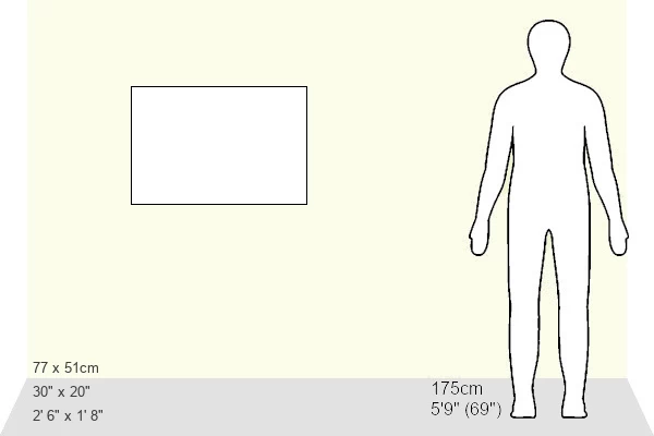
Estimated Product Size is 76.8cm x 51.4cm (30.2" x 20.2")
These are individually made so all sizes are approximate
Artwork printed orientated as per the preview above, with landscape (horizontal) or portrait (vertical) orientation to match the source image.
FEATURES IN THESE COLLECTIONS
> Animals
> Farm
> Cattle
> Related Images
> Animals
> Farm
> Donkeys
> Related Images
> Animals
> Mammals
> Bovidae
> Cattle
> Arts
> Artists
> H
> Franz Hogenberg
> Arts
> Landscape paintings
> Landscape art
> Landscape paintings
> Europe
> France
> Canton
> Landes
> Europe
> Spain
> Related Images
> Maps and Charts
> Related Images
EDITORS COMMENTS
This map print, titled "Burgos" from the atlas "Civitates Orbis Terrarum," was created by the renowned cartographers Georg Braun and Franz Hogenberg in the year 1576. The map is part of the extensive collection housed in the historic Salamanca University Library in Spain. The map provides an intriguing glimpse into the geography and topography of Castile and Leon, specifically the province of Burgos during the 16th century. The intricate detail and vibrant colors of the map bring the landscape to life, depicting a diverse range of landscapes, from rolling hills and lush fields to sprawling cities and bustling markets. The map features several notable landmarks, including the city of Burgos, situated at the heart of the region. The city is shown with its impressive cathedral, surrounded by defensive walls and fortifications. The map also highlights several other towns and villages, connected by winding roads and rivers. The rural areas of the map are filled with images of farmers and herdsmen tending to their livestock, with cattle and sheep grazing in the fields. The use of color adds depth and texture to the map, with different crops depicted in various shades of green and brown. This map is a testament to the remarkable cartographic skills of Braun and Hogenberg, who meticulously documented the world as it was known at the time. It offers a fascinating window into the history and culture of Castile and Leon during the late 16th century, providing valuable insights into the daily life and economic activities of the region.
MADE IN THE USA
Safe Shipping with 30 Day Money Back Guarantee
FREE PERSONALISATION*
We are proud to offer a range of customisation features including Personalised Captions, Color Filters and Picture Zoom Tools
SECURE PAYMENTS
We happily accept a wide range of payment options so you can pay for the things you need in the way that is most convenient for you
* Options may vary by product and licensing agreement. Zoomed Pictures can be adjusted in the Cart.