Premium Framed Print > North America > Haiti > Maps
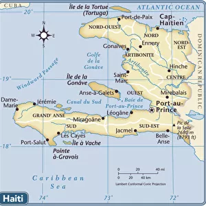
Premium Framed Print : Map of islands of the Caribbean Sea (or Caribbean Sea, Central America), circa 1870. Color lithography, 19th century
, circa 1870. Color lithography, 19th century")
, circa 1870. Color lithography, 19th century")


![]()
Framed Photos from Fine Art Finder
Map of islands of the Caribbean Sea (or Caribbean Sea, Central America), circa 1870. Color lithography, 19th century
NWI4849885 Map of islands of the Caribbean Sea (or Caribbean Sea, Central America), circa 1870. Color lithography, 19th century.; (add.info.: Map of islands of the Caribbean Sea (or Caribbean Sea, Central America), circa 1870. Color lithography, 19th century.); Photo © North Wind Pictures
Media ID 38479466
© © North Wind Pictures / Bridgeman Images
Caribbean Central America Cuba Cuban Dominium Haiti Jamaica Jamaican Geographical Map
14"x16" Premium Frame
Contemporary style Premium Wooden Frame with 8"x10" Print. Complete with 2" White Mat and 1.25" thick MDF frame. Printed on 260 gsm premium paper. Glazed with shatter proof UV coated acrylic glass. Backing is paper covered backing with rubber bumpers. Supplied ready to hang with a pre-installed sawtooth/wire hanger. Care Instructions: Spot clean with a damp cloth. Securely packaged in a clear plastic bag and envelope in a reinforced cardboard shipper
FSC Real Wood Frame and Double Mounted with White Conservation Mountboard - Professionally Made and Ready to Hang
Estimated Image Size (if not cropped) is 25.4cm x 20.3cm (10" x 8")
Estimated Product Size is 40.6cm x 35.6cm (16" x 14")
These are individually made so all sizes are approximate
Artwork printed orientated as per the preview above, with landscape (horizontal) orientation to match the source image.
FEATURES IN THESE COLLECTIONS
> Fine Art Finder
> Artists
> Artist Unknown
> Maps and Charts
> Related Images
> North America
> Cuba
> Maps
> North America
> Cuba
> Related Images
> North America
> Haiti
> Maps
> North America
> Haiti
> Related Images
> North America
> Jamaica
> Maps
> North America
> Jamaica
> Related Images
> North America
> United States of America
> Maps
> Popular Themes
> North Island
EDITORS COMMENTS
This stunning vintage print showcases a beautifully detailed map of the islands of the Caribbean Sea, dating back to circa 1870. Created through color lithography in the 19th century, this piece captures the intricate geography and vibrant hues of the region.
The map features iconic destinations such as Cuba, Jamaica, Haiti, and more, offering a glimpse into the historical layout of these tropical paradises. Each island is meticulously outlined with intricate details that highlight their unique shapes and sizes.
As you gaze upon this artwork, you can't help but be transported back in time to an era when exploration and discovery were at the forefront. The rich colors and precise lines draw you in, inviting you to explore each corner of this enchanting region.
Whether you have a love for cartography or simply appreciate the beauty of vintage prints, this Map of islands of the Caribbean Sea is sure to captivate your imagination. It serves as a reminder of the rich history and cultural significance that these islands hold within our collective memory.
Displaying this piece in your home or office will not only add a touch of elegance but also spark conversations about travel adventures and historical discoveries. Let this exquisite print serve as a window into the past while igniting your sense of wanderlust for future explorations.
MADE IN THE USA
Safe Shipping with 30 Day Money Back Guarantee
FREE PERSONALISATION*
We are proud to offer a range of customisation features including Personalised Captions, Color Filters and Picture Zoom Tools
SECURE PAYMENTS
We happily accept a wide range of payment options so you can pay for the things you need in the way that is most convenient for you
* Options may vary by product and licensing agreement. Zoomed Pictures can be adjusted in the Cart.