Premium Framed Print > Arts > Artists > W > Frederick de Wit
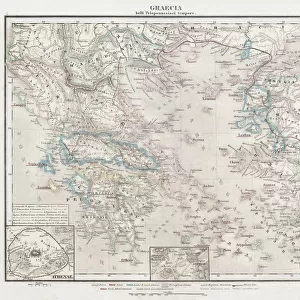
Premium Framed Print : Map of the Franche Comte (France) (etching, 1671)
 (etching, 1671)")

 (etching, 1671)")


![]()
Framed Photos from Fine Art Finder
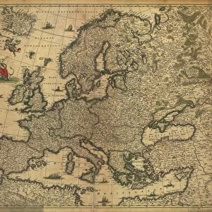
Map of the Franche Comte (France) (etching, 1671)
LRI5621873 Map of the Franche Comte (France) (etching, 1671) by Wit, Frederick de (1630-1706); Private Collection; (add.info.: Carte de la Franche Comte (France) - Eau forte extraite de " Theatrum Orbis", 1671, de Frederick De Wit (Frederico de Witt) (1630-1706) eLuisa Ricciarini/Leemage); Dutch, out of copyright
Media ID 23340548
© Bridgeman Images
Atlas Book Of Maps Franche Comte
14"x16" Premium Frame
Contemporary style Premium Wooden Frame with 8"x10" Print. Complete with 2" White Mat and 1.25" thick MDF frame. Printed on 260 gsm premium paper. Glazed with shatter proof UV coated acrylic glass. Backing is paper covered backing with rubber bumpers. Supplied ready to hang with a pre-installed sawtooth/wire hanger. Care Instructions: Spot clean with a damp cloth. Securely packaged in a clear plastic bag and envelope in a reinforced cardboard shipper
FSC Real Wood Frame and Double Mounted with White Conservation Mountboard - Professionally Made and Ready to Hang
Estimated Image Size (if not cropped) is 25.4cm x 20.3cm (10" x 8")
Estimated Product Size is 40.6cm x 35.6cm (16" x 14")
These are individually made so all sizes are approximate
Artwork printed orientated as per the preview above, with landscape (horizontal) orientation to match the source image.
FEATURES IN THESE COLLECTIONS
> Fine Art Finder
> Artists
> English School
> Fine Art Finder
> Artists
> Frederick de Wit
> Arts
> Artists
> W
> Frederick de Wit
> Maps and Charts
> Related Images
EDITORS COMMENTS
This print showcases a remarkable piece of cartographic history - the "Map of the Franche Comte (France)" etching, created by Frederick de Wit in 1671. With intricate details and exquisite craftsmanship, this map offers a glimpse into the geographical landscape of the Franche Comte region during the 17th century. The etching is extracted from "Theatrum Orbis" a renowned atlas book of maps that was highly regarded for its accuracy and beauty. Created by Dutch cartographer Frederick de Wit, known as Frederico de Witt, this masterpiece reflects his expertise in capturing geographic features with precision. Displayed against a backdrop of faded hues and delicate lines, this vintage map transports us back to an era when exploration and discovery were at their peak. It serves as both an educational tool for understanding historical geography and a work of art that evokes curiosity and wonder. Preserved within a private collection, this rare find reminds us of the importance placed on mapping territories centuries ago. The attention to detail in every contour and landmark demonstrates De Wit's dedication to providing accurate representations while also showcasing his artistic flair. As we admire this enchanting etching by Luisa Ricciarini, let it serve as a reminder that maps not only guide our journeys but also hold stories waiting to be discovered.
MADE IN THE USA
Safe Shipping with 30 Day Money Back Guarantee
FREE PERSONALISATION*
We are proud to offer a range of customisation features including Personalised Captions, Color Filters and Picture Zoom Tools
SECURE PAYMENTS
We happily accept a wide range of payment options so you can pay for the things you need in the way that is most convenient for you
* Options may vary by product and licensing agreement. Zoomed Pictures can be adjusted in the Cart.