Premium Framed Print > Europe > United Kingdom > England > Maps
Premium Framed Print : Avebury / Stukeley Map


![]()
Framed Photos from Mary Evans Picture Library
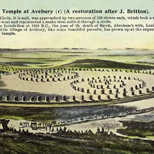
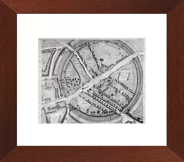
Avebury / Stukeley Map
A beautifully drawn overhead plan of the stone circles and embankment ditches at Avebury. Stukeleys accuracy is impressive, charting every stone, pasture and building
Mary Evans Picture Library makes available wonderful images created for people to enjoy over the centuries
Media ID 623697
© Mary Evans Picture Library 2015 - https://copyrighthub.org/s0/hub1/creation/maryevans/MaryEvansPictureID/10063916
1743 2000 Accuracy Avebury Beautifully Charting Circles Ditches Drawn Earthworks Embankment Impressive Over Head Pasture Plan Publishing Total Stukeley
14"x16" Premium Frame
Contemporary style Premium Wooden Frame with 8"x10" Print. Complete with 2" White Mat and 1.25" thick MDF frame. Printed on 260 gsm premium paper. Glazed with shatter proof UV coated acrylic glass. Backing is paper covered backing with rubber bumpers. Supplied ready to hang with a pre-installed sawtooth/wire hanger. Care Instructions: Spot clean with a damp cloth. Securely packaged in a clear plastic bag and envelope in a reinforced cardboard shipper
FSC Real Wood Frame and Double Mounted with White Conservation Mountboard - Professionally Made and Ready to Hang
Estimated Image Size (if not cropped) is 25.4cm x 20.3cm (10" x 8")
Estimated Product Size is 40.6cm x 35.6cm (16" x 14")
These are individually made so all sizes are approximate
Artwork printed orientated as per the preview above, with landscape (horizontal) orientation to match the source image.
FEATURES IN THESE COLLECTIONS
> Europe
> United Kingdom
> England
> Maps
> Europe
> United Kingdom
> England
> Posters
> Europe
> United Kingdom
> England
> Related Images
> Europe
> United Kingdom
> Heritage Sites
> Stonehenge, Avebury and Associated
> Maps and Charts
> Early Maps
> Maps and Charts
> Related Images
> Popular Themes
> Maps and Charts
EDITORS COMMENTS
This stunning print captures the intricate and detailed overhead plan of Avebury, as charted by the skilled hand of Stukeley in 1743. The accuracy and precision displayed in this map is truly impressive, showcasing every stone, pasture, and building within the ancient stone circles and embankment ditches at Avebury. Stukeley's attention to detail is evident as he meticulously charts the layout of this historical site in England.
As you gaze upon this beautifully drawn map, you can't help but be transported back in time to a place where history comes alive. The earthworks and structures depicted here offer a glimpse into the past, allowing us to see Avebury through Stukeley's eyes.
The total view provided by this overhead plan gives us a bird's eye perspective of Avebury, highlighting the sheer magnitude of these ancient monuments. Each stone and ditch is carefully outlined, creating a comprehensive guide to this remarkable site.
Whether you are an archaeology enthusiast or simply appreciate historical artifacts, this print from Mary Evans Picture Library is sure to captivate your imagination. It serves as a reminder of the rich history that lies beneath our feet and invites us to explore the mysteries of Avebury for ourselves.
MADE IN THE USA
Safe Shipping with 30 Day Money Back Guarantee
FREE PERSONALISATION*
We are proud to offer a range of customisation features including Personalised Captions, Color Filters and Picture Zoom Tools
FREE COLORIZATION SERVICE
You can choose advanced AI Colorization for this picture at no extra charge!
SECURE PAYMENTS
We happily accept a wide range of payment options so you can pay for the things you need in the way that is most convenient for you
* Options may vary by product and licensing agreement. Zoomed Pictures can be adjusted in the Cart.