Premium Framed Print > North America > Dominican Republic > Dominican Republic Heritage Sites > Colonial City of Santo Domingo
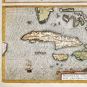
Premium Framed Print : Santo Domingo (Dominican Republic). Hispaniola. Map in 1646
. Hispaniola. Map in 1646")
. Hispaniola. Map in 1646")


![]()
Framed Photos from Mary Evans Picture Library
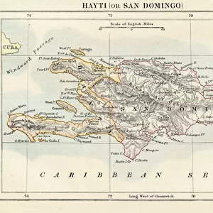
Santo Domingo (Dominican Republic). Hispaniola. Map in 1646
Mary Evans Picture Library makes available wonderful images created for people to enjoy over the centuries
Media ID 14328137
© Thaliastock / Mary Evans
1646 Antilles Caribbean Cartography Colonialism Conquest Continent Domingo Dominican Geography Greater Harbor Hispaniola Santo Urbanism
14"x16" Premium Frame
Contemporary style Premium Wooden Frame with 8"x10" Print. Complete with 2" White Mat and 1.25" thick MDF frame. Printed on 260 gsm premium paper. Glazed with shatter proof UV coated acrylic glass. Backing is paper covered backing with rubber bumpers. Supplied ready to hang with a pre-installed sawtooth/wire hanger. Care Instructions: Spot clean with a damp cloth. Securely packaged in a clear plastic bag and envelope in a reinforced cardboard shipper
FSC Real Wood Frame and Double Mounted with White Conservation Mountboard - Professionally Made and Ready to Hang
Estimated Image Size (if not cropped) is 25.4cm x 20.3cm (10" x 8")
Estimated Product Size is 40.6cm x 35.6cm (16" x 14")
These are individually made so all sizes are approximate
Artwork printed orientated as per the preview above, with landscape (horizontal) orientation to match the source image.
FEATURES IN THESE COLLECTIONS
> Historic
> Colonial America illustrations
> Colonial America
> Historic
> Colonial history
> Colonial art and artists
> Maps and Charts
> Early Maps
> Maps and Charts
> Related Images
> Maps and Charts
> World
> North America
> Dominican Republic
> Dominican Republic Heritage Sites
> Colonial City of Santo Domingo
> North America
> Dominican Republic
> Maps
EDITORS COMMENTS
This intricately detailed map, created in 1646, offers a glimpse into the geographical knowledge of the 17th century, specifically focusing on the island of Hispaniola and its primary city, Santo Domingo, in the Caribbean. During this period, the New World was still a mystery to many Europeans, and maps served as crucial tools for exploration, conquest, and colonialism. Hispaniola, the second largest island in the Greater Antilles, is depicted in the map with its various regions labeled, including the Spanish settlements of Santo Domingo, Concepción, and Santiago. The map also highlights the island's natural features, such as rivers, mountains, and harbors, which were essential for the development of urban centers and the transportation of resources. Santo Domingo, the oldest continuously inhabited European settlement in the Americas, is shown as a bustling city with a well-defined urban layout. The map reveals the presence of a harbor, which was vital for the city's economic growth and its role as a gateway to the New World. The map's title, "Nuevo Mapa de la Isla Española," reflects the Spanish colonial influence on the region. The intricate engraving style of the map is a testament to the advanced cartographic techniques of the time, which allowed for more accurate representations of geographical features. The map's historical significance lies in its ability to provide insights into the early history of the Dominican Republic and the broader context of colonialism and the Age of Discovery.
MADE IN THE USA
Safe Shipping with 30 Day Money Back Guarantee
FREE PERSONALISATION*
We are proud to offer a range of customisation features including Personalised Captions, Color Filters and Picture Zoom Tools
SECURE PAYMENTS
We happily accept a wide range of payment options so you can pay for the things you need in the way that is most convenient for you
* Options may vary by product and licensing agreement. Zoomed Pictures can be adjusted in the Cart.