Canvas Print > North America > Cuba > Cuba Heritage Sites > Old Havana and its Fortification System
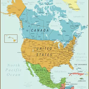
Canvas Print : Geography: map of the Greater Antilles (Cuba, Jamaica, Puerto Rico and the Bahamas) from an Atlas, 1855, Bibliotheque Jose Marti, Havana, Cuba
 from an Atlas, 1855, Bibliotheque Jose Marti, Havana, Cuba")
 from an Atlas, 1855, Bibliotheque Jose Marti, Havana, Cuba")


![]()
Canvas Prints from Fine Art Finder
Geography: map of the Greater Antilles (Cuba, Jamaica, Puerto Rico and the Bahamas) from an Atlas, 1855, Bibliotheque Jose Marti, Havana, Cuba
VEN5031228 Geography: map of the Greater Antilles (Cuba, Jamaica, Puerto Rico and the Bahamas) from an Atlas, 1855, Bibliotheque Jose Marti, Havana, Cuba; (add.info.: Geography: map of the Greater Antilles (Cuba, Jamaica, Puerto Rico and the Bahamas) from an Atlas, 1855, Bibliotheque Jose Marti, Havana, Cuba); © Marage Photos
Media ID 38164356
© © Marage Photos / Bridgeman Images
Amerique Centrale Amerique Du Nord Caraïbes Caribbean Caribbean Island Carte Geographique Central America Etats Unis Geographie Stockravenna Geographical Map
20"x16" (51x41cm) Canvas Print
Explore the beauty and history of the Greater Antilles with this stunning canvas print featuring a vintage map from 1855. Perfect for adding a touch of sophistication to any space, this piece is sure to spark conversation and intrigue among your guests.
Delivered stretched and ready to hang our premium quality canvas prints are made from a polyester/cotton blend canvas and stretched over a 1.25" (32mm) kiln dried knot free wood stretcher bar. Packaged in a plastic bag and secured to a cardboard insert for safe transit.
Canvas Prints add colour, depth and texture to any space. Professionally Stretched Canvas over a hidden Wooden Box Frame and Ready to Hang
Estimated Product Size is 50.8cm x 40.6cm (20" x 16")
These are individually made so all sizes are approximate
Artwork printed orientated as per the preview above, with landscape (horizontal) orientation to match the source image.
FEATURES IN THESE COLLECTIONS
> Maps and Charts
> Early Maps
> Maps and Charts
> Related Images
> North America
> The Bahamas
> Maps
> North America
> The Bahamas
> Related Images
> North America
> Cuba
> Cuba Heritage Sites
> Old Havana and its Fortification System
> North America
> Cuba
> Havana
> North America
> Cuba
> Maps
> North America
> Cuba
> Related Images
> North America
> Jamaica
> Maps
EDITORS COMMENTS
This stunning print captures a detailed map of the Greater Antilles, including Cuba, Jamaica, Puerto Rico, and the Bahamas from an Atlas dating back to 1855. The intricate engraving showcases the geographical features of these Caribbean islands during the 19th century, providing a glimpse into their historical significance.
The Bibliotheque Jose Marti in Havana, Cuba houses this valuable piece of cartographic history, offering a window into the past for those interested in exploring the evolution of these island nations. The map not only serves as a navigational tool but also as a visual representation of the cultural and political landscape of the region at that time.
As we study this map closely, we can appreciate the craftsmanship and attention to detail that went into creating such a precise depiction of landmasses and waterways. Each line and label tells a story about trade routes, colonial influences, and natural resources that shaped the development of these islands over centuries.
Whether you are a geography enthusiast or simply intrigued by historical artifacts, this print is sure to spark curiosity and admiration for the beauty and complexity of our world's diverse landscapes. It serves as a reminder of how maps have played a crucial role in shaping our understanding of different regions and cultures throughout history.
MADE IN THE USA
Safe Shipping with 30 Day Money Back Guarantee
FREE PERSONALISATION*
We are proud to offer a range of customisation features including Personalised Captions, Color Filters and Picture Zoom Tools
SECURE PAYMENTS
We happily accept a wide range of payment options so you can pay for the things you need in the way that is most convenient for you
* Options may vary by product and licensing agreement. Zoomed Pictures can be adjusted in the Cart.