Canvas Print > Asia > Bangladesh > Maps
Canvas Print : Map of the Provinces of the Lower Ganges


![]()
Canvas Prints from Heritage Images
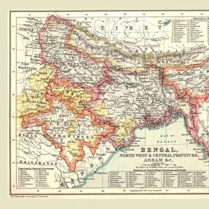
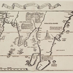
Map of the Provinces of the Lower Ganges
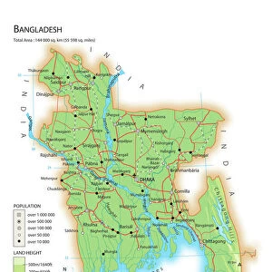
Map of the Provinces of the Lower Ganges. Map in two sections, showing Indian states through which the River Ganges flows, and the Ganges Delta in what is now Bangladesh. Plate 59 from The Times Atlas
Heritage Images features heritage image collections
Media ID 15464452
© The Print Collector / Heritage-Images
Bangladesh Bihar Cartography Ganges Map Making Orissa River Ganges Assam
20"x16" (51x41cm) Canvas Print
Discover the rich history and cultural significance of the Lower Ganges region with our stunning Canvas Prints from Media Storehouse. This captivating Map of the Provinces of the Lower Ganges, sourced from Heritage Images, is expertly reproduced in vibrant colors and high-quality detail on a premium canvas. Two sections of the map are skillfully combined, depicting the Indian states through which the sacred River Ganges flows, and the breathtaking Ganges Delta in present-day Bangladesh. Elevate your home or office decor with this beautiful and intriguing piece of art that tells a story of history, geography, and tradition.
Delivered stretched and ready to hang our premium quality canvas prints are made from a polyester/cotton blend canvas and stretched over a 1.25" (32mm) kiln dried knot free wood stretcher bar. Packaged in a plastic bag and secured to a cardboard insert for safe transit.
Canvas Prints add colour, depth and texture to any space. Professionally Stretched Canvas over a hidden Wooden Box Frame and Ready to Hang
Estimated Product Size is 40.6cm x 50.8cm (16" x 20")
These are individually made so all sizes are approximate
Artwork printed orientated as per the preview above, with portrait (vertical) orientation to match the source image.
FEATURES IN THESE COLLECTIONS
> Asia
> Bangladesh
> Maps
> Asia
> Bangladesh
> Related Images
> Asia
> India
> Related Images
> Maps and Charts
> India
> Maps and Charts
> Related Images
EDITORS COMMENTS
This print showcases a historic "Map of the Provinces of the Lower Ganges". Divided into two sections, it vividly depicts the Indian states through which the mighty River Ganges gracefully flows, as well as the mesmerizing Ganges Delta in what is now Bangladesh. Plate 59 from The Times Atlas, this map offers a remarkable glimpse into the artistry and precision of cartography. The vibrant colors used in this map bring to life the diverse provinces along the lower course of the Ganges. From Assam to Bihar and Orissa, each state is meticulously outlined with intricate details that highlight their unique geographical features. This print serves as a testament to both India's rich history and its deep connection with one of its most sacred rivers. Crafted by an unknown artist, this map captures not only physical boundaries but also cultural significance. It symbolizes how rivers like the Ganges have shaped civilizations over centuries, providing sustenance and spirituality to millions who reside along its banks. Preserved by The Print Collector, this image invites us on a visual journey through time and space. Whether you are an avid traveler or simply fascinated by maps, this stunning piece will undoubtedly ignite your curiosity about these enchanting regions nestled around one of Asia's most iconic waterways - The River Ganges.
MADE IN THE USA
Safe Shipping with 30 Day Money Back Guarantee
FREE PERSONALISATION*
We are proud to offer a range of customisation features including Personalised Captions, Color Filters and Picture Zoom Tools
SECURE PAYMENTS
We happily accept a wide range of payment options so you can pay for the things you need in the way that is most convenient for you
* Options may vary by product and licensing agreement. Zoomed Pictures can be adjusted in the Cart.