Canvas Print > Maps and Charts > Early Maps
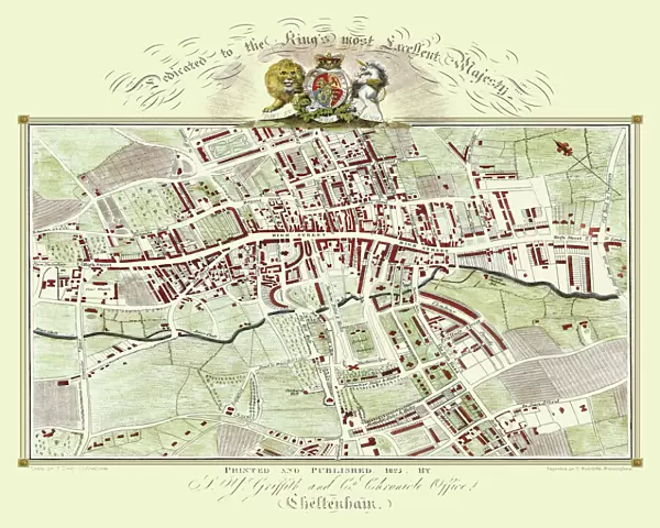
Canvas Print : Old Map of Cheltenham 1825 by Griffith s


![]()
Canvas Prints from MapSeeker
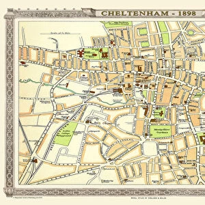
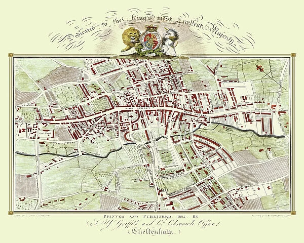
Old Map of Cheltenham 1825 by Griffith s
Fine reproduction in full colour of Griffiths new historical description of Cheltenham and its vicinity originally published in 1825
Welcome to the Mapseeker Image library and enter an historic gateway to one of the largest on-line collections of Historic Maps, Nostalgic Views, Vista's and Panorama's from a World gone by.
Media ID 20348068
Historic Map Old Town Plan Town Plan Cheltenham
20"x16" (51x41cm) Canvas Print
"Discover the rich history of Cheltenham with our stunning Canvas Print of the Old Map of Cheltenham 1825 by Griffiths. This fine reproduction, sourced from MapSeeker, brings to life the intricate details of the historical description of Cheltenham and its vicinity as originally published in 1825. With vibrant full-color detail, this Canvas Print is not just a decorative piece, but a window into the past. Bring the history of Cheltenham into your home and add a touch of timeless charm to your interior décor with our high-quality Canvas Print of the Old Map of Cheltenham 1825 by Griffiths."
Delivered stretched and ready to hang our premium quality canvas prints are made from a polyester/cotton blend canvas and stretched over a 1.25" (32mm) kiln dried knot free wood stretcher bar. Packaged in a plastic bag and secured to a cardboard insert for safe transit.
Canvas Prints add colour, depth and texture to any space. Professionally Stretched Canvas over a hidden Wooden Box Frame and Ready to Hang
Estimated Product Size is 50.8cm x 40.6cm (20" x 16")
These are individually made so all sizes are approximate
Artwork printed orientated as per the preview above, with landscape (horizontal) orientation to match the source image.
FEATURES IN THESE COLLECTIONS
> Maps and Charts
> Early Maps
> Maps and Charts
> Related Images
> MapSeeker
> British Town And City Plans
> English & Welsh PORTFOLIO
EDITORS COMMENTS
This stunning print showcases an exquisite reproduction of the "Old Map of Cheltenham 1825" by Griffiths, a renowned cartographer. Immerse yourself in the rich history and charm of this vibrant town with this fine reproduction, presented in full color. Originally published in 1825, this historical map provides a fascinating glimpse into Cheltenham's past. Every intricate detail has been faithfully reproduced to capture the essence of the original work. From its elegant streets to its bustling marketplaces, this map offers a captivating insight into what life was like in Cheltenham almost two centuries ago. The town plan depicted on this old map is meticulously crafted, showcasing the layout and landmarks that defined Cheltenham during that era. Whether you are a history enthusiast or simply curious about your hometown's roots, this historic Cheltenham map is sure to transport you back in time. Perfect for framing or displaying as part of your collection, this print allows you to appreciate the beauty and craftsmanship of Griffiths' work from the comfort of your own home. Discover how Cheltenham has evolved over time while marveling at its enduring architectural heritage
MADE IN THE USA
Safe Shipping with 30 Day Money Back Guarantee
FREE PERSONALISATION*
We are proud to offer a range of customisation features including Personalised Captions, Color Filters and Picture Zoom Tools
SECURE PAYMENTS
We happily accept a wide range of payment options so you can pay for the things you need in the way that is most convenient for you
* Options may vary by product and licensing agreement. Zoomed Pictures can be adjusted in the Cart.