Framed Print > Maps and Charts > Early Maps
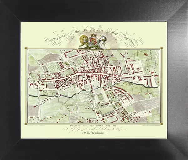
Framed Print : Old Map of Cheltenham 1825 by Griffith s


![]()
Framed Photos from MapSeeker
Old Map of Cheltenham 1825 by Griffith s
Fine reproduction in full colour of Griffiths new historical description of Cheltenham and its vicinity originally published in 1825
Welcome to the Mapseeker Image library and enter an historic gateway to one of the largest on-line collections of Historic Maps, Nostalgic Views, Vista's and Panorama's from a World gone by.
Media ID 20348068
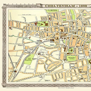
Historic Map Old Town Plan Town Plan Cheltenham
12"x10" Modern Frame
Step back in time with our exquisite Framed Prints from Media Storehouse, featuring an Old Map of Cheltenham from 1825 by Griffiths. This fine reproduction in full colour showcases the historical description of Cheltenham and its vicinity as it was originally published over 190 years ago. Each print is meticulously framed to preserve its antique charm and add a touch of elegance to your home or office decor. Discover the rich history of Cheltenham through this intricately detailed map, a beautiful addition to any collection.
10x8 Print in an MDF Wooden Frame with 180 gsm Satin Finish Paper. Glazed using shatter proof thin plexi glass. Frame thickness is 1 inch and depth 0.75 inch. Fluted cardboard backing held with clips. Supplied ready to hang with sawtooth hanger and rubber bumpers. Spot clean with a damp cloth. Packaged foam wrapped in a card.
Contemporary Framed and Mounted Prints - Professionally Made and Ready to Hang
Estimated Image Size (if not cropped) is 25.4cm x 25.4cm (10" x 10")
Estimated Product Size is 30.5cm x 25.4cm (12" x 10")
These are individually made so all sizes are approximate
Artwork printed orientated as per the preview above, with landscape (horizontal) or portrait (vertical) orientation to match the source image.
FEATURES IN THESE COLLECTIONS
> Maps and Charts
> Early Maps
> Maps and Charts
> Related Images
> MapSeeker
> British Town And City Plans
> English & Welsh PORTFOLIO
EDITORS COMMENTS
This stunning print showcases an exquisite reproduction of the "Old Map of Cheltenham 1825" by Griffiths, a renowned cartographer. Immerse yourself in the rich history and charm of this vibrant town with this fine reproduction, presented in full color. Originally published in 1825, this historical map provides a fascinating glimpse into Cheltenham's past. Every intricate detail has been faithfully reproduced to capture the essence of the original work. From its elegant streets to its bustling marketplaces, this map offers a captivating insight into what life was like in Cheltenham almost two centuries ago. The town plan depicted on this old map is meticulously crafted, showcasing the layout and landmarks that defined Cheltenham during that era. Whether you are a history enthusiast or simply curious about your hometown's roots, this historic Cheltenham map is sure to transport you back in time. Perfect for framing or displaying as part of your collection, this print allows you to appreciate the beauty and craftsmanship of Griffiths' work from the comfort of your own home. Discover how Cheltenham has evolved over time while marveling at its enduring architectural heritage
MADE IN THE USA
Safe Shipping with 30 Day Money Back Guarantee
FREE PERSONALISATION*
We are proud to offer a range of customisation features including Personalised Captions, Color Filters and Picture Zoom Tools
SECURE PAYMENTS
We happily accept a wide range of payment options so you can pay for the things you need in the way that is most convenient for you
* Options may vary by product and licensing agreement. Zoomed Pictures can be adjusted in the Cart.