Poster Print > Maps and Charts > Early Maps
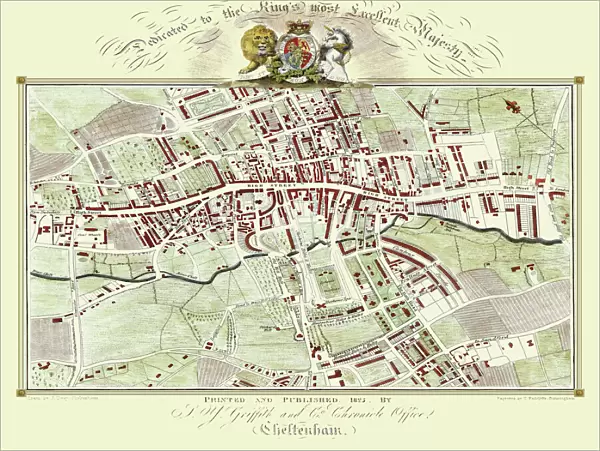
Poster Print : Old Map of Cheltenham 1825 by Griffith s


![]()
Poster Prints from MapSeeker
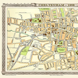
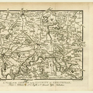
Old Map of Cheltenham 1825 by Griffith s
Fine reproduction in full colour of Griffiths new historical description of Cheltenham and its vicinity originally published in 1825
Welcome to the Mapseeker Image library and enter an historic gateway to one of the largest on-line collections of Historic Maps, Nostalgic Views, Vista's and Panorama's from a World gone by.
Media ID 20348068
Historic Map Old Town Plan Town Plan Cheltenham
18x24 inch Poster Print
"Step back in time with our Old Map of Cheltenham 1825 by Griffiths, now available as a stunning poster print from Media Storehouse. This beautiful, fine reproduction in full colour brings to life the historical description of Cheltenham and its vicinity, originally published in 1825 by MapSeeker. Add an air of sophistication and intrigue to any room with this captivating and authentic representation of Cheltenham's rich history. Order your Old Map of Cheltenham 1825 poster print today and let the stories of the past unfold in your home or office."
Poster prints are budget friendly enlarged prints in standard poster paper sizes. Printed on 150 gsm Matte Paper for a natural feel and supplied rolled in a tube. Great for framing and should last many years. To clean wipe with a microfiber, non-abrasive cloth or napkin. Our Archival Quality Photo Prints and Fine Art Paper Prints are printed on higher quality paper and the choice of which largely depends on your budget.
Poster prints are budget friendly enlarged prints in standard poster paper sizes (A0, A1, A2, A3 etc). Whilst poster paper is sometimes thinner and less durable than our other paper types, they are still ok for framing and should last many years. Our Archival Quality Photo Prints and Fine Art Paper Prints are printed on higher quality paper and the choice of which largely depends on your budget.
Estimated Product Size is 61.6cm x 46.3cm (24.3" x 18.2")
These are individually made so all sizes are approximate
Artwork printed orientated as per the preview above, with landscape (horizontal) orientation to match the source image.
FEATURES IN THESE COLLECTIONS
> MapSeeker
> British Town And City Plans
> English & Welsh PORTFOLIO
> Maps and Charts
> Early Maps
> Maps and Charts
> Related Images
EDITORS COMMENTS
This stunning print showcases an exquisite reproduction of the "Old Map of Cheltenham 1825" by Griffiths, a renowned cartographer. Immerse yourself in the rich history and charm of this vibrant town with this fine reproduction, presented in full color. Originally published in 1825, this historical map provides a fascinating glimpse into Cheltenham's past. Every intricate detail has been faithfully reproduced to capture the essence of the original work. From its elegant streets to its bustling marketplaces, this map offers a captivating insight into what life was like in Cheltenham almost two centuries ago. The town plan depicted on this old map is meticulously crafted, showcasing the layout and landmarks that defined Cheltenham during that era. Whether you are a history enthusiast or simply curious about your hometown's roots, this historic Cheltenham map is sure to transport you back in time. Perfect for framing or displaying as part of your collection, this print allows you to appreciate the beauty and craftsmanship of Griffiths' work from the comfort of your own home. Discover how Cheltenham has evolved over time while marveling at its enduring architectural heritage
MADE IN THE USA
Safe Shipping with 30 Day Money Back Guarantee
FREE PERSONALISATION*
We are proud to offer a range of customisation features including Personalised Captions, Color Filters and Picture Zoom Tools
SECURE PAYMENTS
We happily accept a wide range of payment options so you can pay for the things you need in the way that is most convenient for you
* Options may vary by product and licensing agreement. Zoomed Pictures can be adjusted in the Cart.