Canvas Print > Europe > United Kingdom > England > Oxfordshire > Oxford
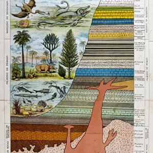
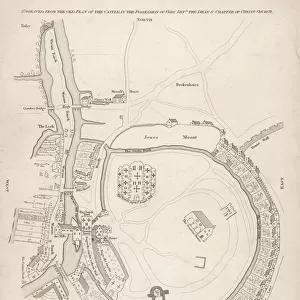
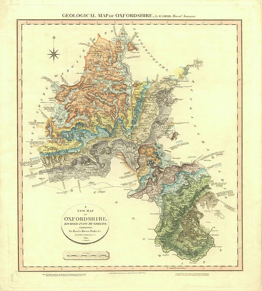
Canvas Print : Geological Map of Oxfordshire


![]()
Canvas Prints from Mary Evans Picture Library
Geological Map of Oxfordshire
Delineation of Strata of Oxfordshire by William Smith
Mary Evans Picture Library makes available wonderful images created for people to enjoy over the centuries
Media ID 8609878
© Mary Evans Picture Library 2015 - https://copyrighthub.org/s0/hub1/creation/maryevans/MaryEvansPictureID/10714291
Geological Geology Great Britain Oxford Oxfordshire Strata Stratification Stratigraphical Stratigraphy William Smith
20"x16" (51x41cm) Canvas Print
"Discover the rich geological history of Oxfordshire with our stunning Canvas Print of the Delineation of Strata by William Smith, available in the Media Storehouse range. This captivating print, sourced from Mary Evans Prints Online, showcases an intricately detailed geological map of Oxfordshire. Each canvas print is expertly crafted with high-quality materials and vibrant colors, ensuring a beautiful and long-lasting addition to your home or office decor. Delve into the fascinating world of geology and add a touch of academic elegance to your space with this unique and thought-provoking piece."
Delivered stretched and ready to hang our premium quality canvas prints are made from a polyester/cotton blend canvas and stretched over a 1.25" (32mm) kiln dried knot free wood stretcher bar. Packaged in a plastic bag and secured to a cardboard insert for safe transit.
Canvas Prints add colour, depth and texture to any space. Professionally Stretched Canvas over a hidden Wooden Box Frame and Ready to Hang
Estimated Product Size is 40.6cm x 50.8cm (16" x 20")
These are individually made so all sizes are approximate
Artwork printed orientated as per the preview above, with portrait (vertical) orientation to match the source image.
FEATURES IN THESE COLLECTIONS
> Arts
> Artists
> S
> Mary Smith
> Europe
> Related Images
> Europe
> United Kingdom
> England
> Maps
> Europe
> United Kingdom
> England
> Oxford
> Europe
> United Kingdom
> England
> Oxfordshire
> Oxford
> Europe
> United Kingdom
> England
> Oxfordshire
> Related Images
> Europe
> United Kingdom
> England
> Posters
> Europe
> United Kingdom
> England
> Related Images
> Maps and Charts
> Geological Map
> Maps and Charts
> Related Images
EDITORS COMMENTS
This stunning print showcases the intricate details of the "Geological Map of Oxfordshire" created by William Smith. The map, which delineates the various strata of Oxfordshire, provides a fascinating glimpse into the geological history of this region in Great Britain. From the vibrant colors representing different rock formations to the precise stratigraphical markings, this map is a true work of art that combines science and aesthetics.
William Smith's meticulous research and dedication to accurately depicting the geology of Oxfordshire are evident in every line and color on this map. His pioneering work laid the foundation for modern stratigraphy and revolutionized our understanding of Earth's history.
As we gaze upon this print, we are transported back in time to when these rocks were formed millions of years ago. Each layer tells a story of ancient oceans, volcanic eruptions, and tectonic shifts that have shaped the landscape we see today.
Whether you are a geology enthusiast or simply appreciate beautiful artwork, this print is sure to captivate your imagination. It serves as a reminder of how much we can learn from studying the rocks beneath our feet and how interconnected our world truly is.
MADE IN THE USA
Safe Shipping with 30 Day Money Back Guarantee
FREE PERSONALISATION*
We are proud to offer a range of customisation features including Personalised Captions, Color Filters and Picture Zoom Tools
SECURE PAYMENTS
We happily accept a wide range of payment options so you can pay for the things you need in the way that is most convenient for you
* Options may vary by product and licensing agreement. Zoomed Pictures can be adjusted in the Cart.