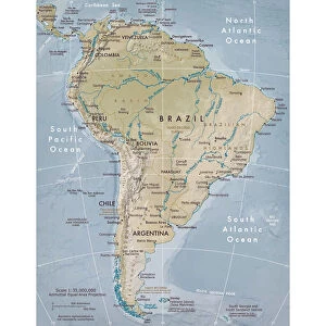
Canvas Print > South America > Related Images
Canvas Print : Topographic view of Central America


![]()
Canvas Prints from Stocktrek
Topographic view of Central America
Panama, Costa Rica, Nicaragua, El Salvador, Honduras, Guatemala, Belize, southern Mexico and parts of Cuba and Jamaica are all seen in this image from the Shuttle Radar Topography Mission. The dominant feature of the northern part of Central America is the Sierra Madre Range, spreading east from Mexico between the narrow Pacific coastal plain and the limestone lowland of the Yucatan Peninsula. Parallel hill ranges sweep across Honduras and extend south, past the Caribbean Mosquito Coast to lakes Managua and Nicaragua. The Cordillera Central rises to the south, gradually descending to Lake Gatun and the Isthmus of Panama. A highly active volcanic belt runs along the Pacific seaboard from Mexico to Costa Rica.
High-quality satellite imagery of Central America has, until now, been difficult to obtain due to persistent cloud cover in this region of the world. The ability of SRTM to penetrate clouds and make three-dimensional measurements has allowed the generation of the first complete high-resolution topographic map of the entire region. This map was used to generate the image.
Two visualization methods were combined to produce the image: shading and color coding of topographic height. The shade image was derived by computing topographic slope in the north-south direction. Color coding is directly related to topographic height, with green at the lower elevations, rising through yellow, red, and magenta, to white at the highest elevations
Stocktrek Images specializes in Astronomy, Dinosaurs, Medical, Military Forces, Ocean Life, & Sci-Fi
Media ID 13057941
© Stocktrek Images
Belize Cartography Central America Costa Rica Cuba Elevated Guatemala Honduras Jamaica Land Feature Landform Mexico Nicaragua Peninsula Plains Satellite View Topography Yucatan Cordillera Central El Salvador Isthmus Isthmus Of Panama Managua Panama View From Space
20"x16" (51x41cm) Canvas Print
Experience the breathtaking topography of Central America with our Media Storehouse Canvas Prints. This stunning image, captured by Stocktrek Images from the Shuttle Radar Topography Mission, showcases a unique perspective of Central America, revealing intricate details of the landscapes in Panama, Costa Rica, Nicaragua, El Salvador, Honduras, Guatemala, Belize, southern Mexico, Cuba, and Jamaica. Our premium canvas prints are meticulously crafted to bring out the vibrant colors and textures of the image, creating a beautiful and captivating piece of art for your home or office. Order now and bring the wonders of Central America right into your living space.
Delivered stretched and ready to hang our premium quality canvas prints are made from a polyester/cotton blend canvas and stretched over a 1.25" (32mm) kiln dried knot free wood stretcher bar. Packaged in a plastic bag and secured to a cardboard insert for safe transit.
Canvas Prints add colour, depth and texture to any space. Professionally Stretched Canvas over a hidden Wooden Box Frame and Ready to Hang
Estimated Product Size is 50.8cm x 40.6cm (20" x 16")
These are individually made so all sizes are approximate
Artwork printed orientated as per the preview above, with landscape (horizontal) orientation to match the source image.
FEATURES IN THESE COLLECTIONS
> North America
> Related Images
> South America
> Related Images
EDITORS COMMENTS
This print showcases a topographic view of Central America, revealing the stunning landscapes and geographical features of this diverse region. From Panama to Belize, and even parts of Cuba and Jamaica, this image from the Shuttle Radar Topography Mission captures it all. The dominant feature in the northern part of Central America is the majestic Sierra Madre Range, which stretches east from Mexico between the narrow Pacific coastal plain and the limestone lowland of the Yucatan Peninsula. As we explore further south, parallel hill ranges sweep across Honduras before extending past the Caribbean Mosquito Coast to lakes Managua and Nicaragua. The Cordillera Central rises to the south, gradually descending towards Lake Gatun and eventually leading us to the iconic Isthmus of Panama. Alongside these breathtaking landforms lies a highly active volcanic belt that runs along the Pacific seaboard from Mexico all the way down to Costa Rica. What makes this image truly remarkable is its high-resolution quality achieved through advanced satellite technology. Previously hindered by persistent cloud cover in this region, obtaining clear satellite imagery was challenging until now. Thanks to SRTM's ability to penetrate clouds and make three-dimensional measurements, we can now enjoy an unprecedented complete topographic map of Central America. The visualization methods used in creating this image are equally impressive - combining shading with color coding based on topographic height. Shades were derived by computing topographic slope in a north-south direction while colors directly correspond to elevation levels; green for lower elevations rising through yellow, red, magenta until reaching white at highest peaks. This extraordinary piece was brought to you by Stocktrek Images - an awe-inspiring representation capturing both beauty and scientific significance simultaneously.
MADE IN THE USA
Safe Shipping with 30 Day Money Back Guarantee
FREE PERSONALISATION*
We are proud to offer a range of customisation features including Personalised Captions, Color Filters and Picture Zoom Tools
SECURE PAYMENTS
We happily accept a wide range of payment options so you can pay for the things you need in the way that is most convenient for you
* Options may vary by product and licensing agreement. Zoomed Pictures can be adjusted in the Cart.