Home > North America > Nicaragua > Lakes > Lake Nicaragua
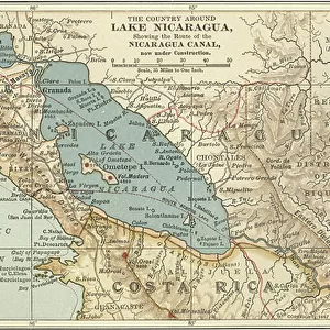
Map showing the Nicaraguan Canal, a proposed shipping route through Nicaragua via Lake Nicaragua in the first decade of the 20th century, which would have connected the Atlantic and the Pacific Oceans. The plan never went ahead after the building of the Panama canal. From The Business Encyclopaedia and Legal Adviser, published 1907

![]()
Wall Art and Photo Gifts from Design Pics
Map showing the Nicaraguan Canal, a proposed shipping route through Nicaragua via Lake Nicaragua in the first decade of the 20th century, which would have connected the Atlantic and the Pacific Oceans. The plan never went ahead after the building of the Panama canal. From The Business Encyclopaedia and Legal Adviser, published 1907
Design Pics offers Distinctively Different Imagery representing over 1,500 contributors
Media ID 24906353
© Ken Welsh
20th Century Atlantic Ocean Canals Central America Central American Connected Connection Man Made Pacific Ocean Plan Waterway Waterways Lake Nicaragua Nicaragua Proposed Shipping Route
FEATURES IN THESE COLLECTIONS
> Maps and Charts
> Early Maps
> Maps and Charts
> Related Images
> North America
> Nicaragua
> Lakes
> Lake Nicaragua
> North America
> Nicaragua
> Lakes
> Related Images
> North America
> Nicaragua
> Maps
> North America
> Nicaragua
> Related Images
> North America
> Panama
> Lakes
> Related Images
> North America
> Panama
> Maps
> North America
> Panama
> Related Images
MADE IN THE USA
Safe Shipping with 30 Day Money Back Guarantee
FREE PERSONALISATION*
We are proud to offer a range of customisation features including Personalised Captions, Color Filters and Picture Zoom Tools
SECURE PAYMENTS
We happily accept a wide range of payment options so you can pay for the things you need in the way that is most convenient for you
* Options may vary by product and licensing agreement. Zoomed Pictures can be adjusted in the Cart.