Home > Europe > France > Canton > Vendee
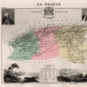
La Vendee (85), Pays de la Loire, - France and its Colonies. Atlas illustrates one hundred and five maps from the maps of the depot of war, bridges and footwear and the Navy by M. VUILLEMIN. 1876
, Pays de la Loire, - France and its Colonies. Atlas illustrates one hundred and five maps from the maps of the depot of war, bridges and footwear and the Navy by M. VUILLEMIN. 1876")
![]()
Wall Art and Photo Gifts from Fine Art Finder
La Vendee (85), Pays de la Loire, - France and its Colonies. Atlas illustrates one hundred and five maps from the maps of the depot of war, bridges and footwear and the Navy by M. VUILLEMIN. 1876
XEE4144421 La Vendee (85), Pays de la Loire, - France and its Colonies. Atlas illustrates one hundred and five maps from the maps of the depot of war, bridges and footwear and the Navy by M. VUILLEMIN. 1876. by Vuillemin, Alexandre (1812-1886); Private Collection; (add.info.: La Vendee (85), Pays de la Loire, - France and its Colonies. Atlas illustrates one hundred and five maps from the maps of the depot of war, bridges and footwear and the Navy by M. VUILLEMIN. 1876.); Stefano Bianchetti
Media ID 25216670
© Stefano Bianchetti / Bridgeman Images
Alexandre Vuillemin Atlas Book City Map City Plan E 85 General Map Loire Country Street Plan Vend And Xe9 Vendee 85 Vuillemin Alexandre 1812 1886 Geographical Map
FEATURES IN THESE COLLECTIONS
> Arts
> Portraits
> Pop art gallery
> Street art portraits
> Europe
> France
> Canton
> Loire
> Europe
> France
> Canton
> Vendee
> Fine Art Finder
> Artists
> Alexandre Vuillemin
> Maps and Charts
> Early Maps
> Maps and Charts
> Related Images
> Services
> Royal Navy
EDITORS COMMENTS
This print showcases a stunning geographical map titled "La Vendee (85), Pays de la Loire, - France and its Colonies". Created by Alexandre Vuillemin in 1876, this atlas illustrates one hundred and five maps from the depot of war, bridges and footwear, as well as the Navy. The intricate details and vibrant colors bring this 19th-century artwork to life. The map focuses on La Vendee region in France's Pays de la Loire area, along with its colonies. It provides a comprehensive overview of the region's geography, including cities, streets, and landmarks. Alexandre Vuillemin's expertise as an engraver is evident in every stroke of his artistic hand. The artist's attention to detail is remarkable; each element is meticulously crafted to ensure accuracy and beauty. This particular print captures the essence of 19th-century cartography while showcasing Vuillemin's talent for creating visually striking works of art. Whether you are a history enthusiast or simply appreciate fine art, this print offers a glimpse into French culture during that era. It serves as both an educational tool and a decorative piece for any space. Stefano Bianchetti has skillfully captured this engraving with precision and clarity. His photography allows us to admire the intricate details up close while preserving the integrity of the original artwork.
MADE IN THE USA
Safe Shipping with 30 Day Money Back Guarantee
FREE PERSONALISATION*
We are proud to offer a range of customisation features including Personalised Captions, Color Filters and Picture Zoom Tools
SECURE PAYMENTS
We happily accept a wide range of payment options so you can pay for the things you need in the way that is most convenient for you
* Options may vary by product and licensing agreement. Zoomed Pictures can be adjusted in the Cart.