Home > Europe > United Kingdom > Wales > Maps
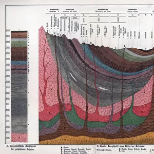
Royal Atlas, c 1900: Geological Features (colour litho)
")
![]()
Wall Art and Photo Gifts from Fine Art Finder
Royal Atlas, c 1900: Geological Features (colour litho)
7198197 Royal Atlas, c 1900: Geological Features (colour litho) by English School, (20th century); Private Collection; (add.info.: Geological Features. Illustration for The Royal Atlas of England and Wales, reduced from the Ordnance Survey, edited by J G Bartholomew [1860-1920] (George Newnes, c 1900).); © Look and Learn
Media ID 24714192
© Look and Learn / Bridgeman Images
City Map City Plan General Map Geological Geological Features Geology Mineralogy Street Plan
FEATURES IN THESE COLLECTIONS
> Europe
> United Kingdom
> England
> Maps
> Europe
> United Kingdom
> Maps
> Europe
> United Kingdom
> Wales
> Maps
> Europe
> United Kingdom
> Wales
> Posters
> Europe
> United Kingdom
> Wales
> Related Images
> Fine Art Finder
> Artists
> English School
> Maps and Charts
> Early Maps
> Maps and Charts
> Geological Map
> Maps and Charts
> Related Images
> Maps and Charts
> Wales
EDITORS COMMENTS
This print titled "Royal Atlas, c 1900: Geological Features" takes us back to the early twentieth century and offers a glimpse into the scientific world of geology. The image showcases a color lithograph from the Royal Atlas of England and Wales, edited by J G Bartholomew. The geological features depicted in this artwork are both visually striking and scientifically informative. With vibrant colors and intricate details, the lithograph presents a map that highlights various geological formations across England. From rolling hills to jagged cliffs, each feature tells its own story about the Earth's history. As we explore this piece further, it becomes evident that science played a crucial role in creating such detailed maps. Scientific methods were employed to study mineralogy and understand how different geological structures formed over time. This illustration serves as a testament to human curiosity and our desire to unravel the mysteries of our planet. Beyond its scientific significance, this print also captures the essence of early twentieth-century England. It reminds us of an era when cartography was highly valued for city planning purposes with general maps and street plans being essential tools for urban development. Overall, this print is not only aesthetically pleasing but also provides valuable insights into both scientific advancements and historical context during that period.
MADE IN THE USA
Safe Shipping with 30 Day Money Back Guarantee
FREE PERSONALISATION*
We are proud to offer a range of customisation features including Personalised Captions, Color Filters and Picture Zoom Tools
SECURE PAYMENTS
We happily accept a wide range of payment options so you can pay for the things you need in the way that is most convenient for you
* Options may vary by product and licensing agreement. Zoomed Pictures can be adjusted in the Cart.