Home > Arts > Artists > B > Willem Blaeu
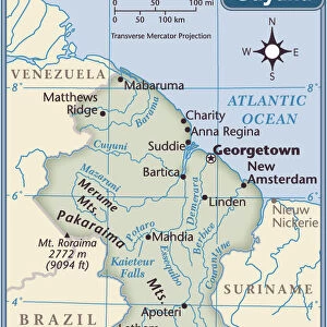
Geography map: representation of Guyana in the Amazon in South America from an Atlas made by cartographer Willem Janszoon Blaeu (1571-1638), approximately 1630. Biblioteca Angelica, Rome
, approximately 1630. Biblioteca Angelica, Rome")
![]()
Wall Art and Photo Gifts from Fine Art Finder
Geography map: representation of Guyana in the Amazon in South America from an Atlas made by cartographer Willem Janszoon Blaeu (1571-1638), approximately 1630. Biblioteca Angelica, Rome
VEN5030358 Geography map: representation of Guyana in the Amazon in South America from an Atlas made by cartographer Willem Janszoon Blaeu (1571-1638), approximately 1630. Biblioteca Angelica, Rome; (add.info.: Geography map: representation of Guyana in the Amazon in South America from an Atlas made by cartographer Willem Janszoon Blaeu (1571-1638), approximately 1630. Biblioteca Angelica, Rome); © Marage Photos
Media ID 38350292
© © Marage Photos / Bridgeman Images
17eme Siecle Amazonia Amazonian Amazonians Amerique (continent) Amerique Du Nord Amerique Du Sud Carte Geographique Etats Unis Geographie Guyana Latin America Stockravenna
FEATURES IN THESE COLLECTIONS
> Arts
> Artists
> B
> Willem Blaeu
> Fine Art Finder
> Artists
> Francois Xavier Fabre
> Maps and Charts
> Early Maps
> North America
> United States of America
> Maps
> South America
> Guyana
> Maps
> South America
> Guyana
> Related Images
EDITORS COMMENTS
This stunning print of a geography map, depicting Guyana in the Amazon region of South America, is a true masterpiece from the 17th century. Created by renowned cartographer Willem Janszoon Blaeu around 1630, this intricate representation showcases the beauty and complexity of the natural world as seen through the eyes of early explorers.
The detailed engravings on this map offer a glimpse into the rich biodiversity and vast landscapes of the Amazon rainforest, highlighting its importance as one of the most diverse ecosystems on Earth. The accuracy and artistry displayed in this work reflect both scientific knowledge and artistic skill, making it a valuable historical document for understanding our planet's geographical features.
Displayed in Biblioteca Angelica in Rome, this map serves as a reminder of the adventurous spirit that drove explorers to chart unknown territories and expand our understanding of the world. It captures a moment in time when discovery and curiosity fueled exploration, leading to new insights about distant lands and cultures.
As we admire this ancient cartographic treasure today, we are reminded of how far we have come in our understanding of geography while also appreciating the timeless beauty captured by artists like Blaeu. This print is not just a representation of Guyana but also a window into an era when maps were more than just navigational tools—they were works of art that inspired wonder and awe.
MADE IN THE USA
Safe Shipping with 30 Day Money Back Guarantee
FREE PERSONALISATION*
We are proud to offer a range of customisation features including Personalised Captions, Color Filters and Picture Zoom Tools
SECURE PAYMENTS
We happily accept a wide range of payment options so you can pay for the things you need in the way that is most convenient for you
* Options may vary by product and licensing agreement. Zoomed Pictures can be adjusted in the Cart.