Home > Arts > Landscape paintings > Cityscape art > Urban cityscapes
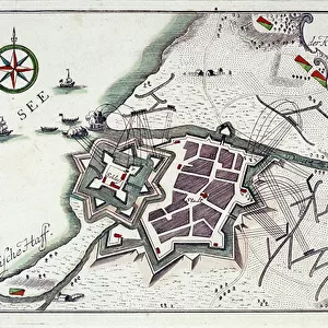
Plan of Memel (present-day Klaipeda, Lithuania), during the surrender of the city, 27 June to 5 July 1757. Etching water in 1764 colors
, during the surrender of the city, 27 June to 5 July 1757. Etching water in 1764 colors")
![]()
Wall Art and Photo Gifts from Fine Art Finder
Plan of Memel (present-day Klaipeda, Lithuania), during the surrender of the city, 27 June to 5 July 1757. Etching water in 1764 colors
MMM5482024 Plan of Memel (present-day Klaipeda, Lithuania), during the surrender of the city, 27 June to 5 July 1757. Etching water in 1764 colors.; National Maritime Museum, London, UK; (add.info.: Plan of Memel (present-day Klaipeda, Lithuania), during the surrender of the city, 27 June to 5 July 1757. Etching water in 1764 colors.); © National Maritime Museum, Greenwich, London
Media ID 38510372
© © National Maritime Museum, Greenwich, London / Bridgeman Images
Baltics City Scape Coast Line Compass Card Compass Rose Compass Star East Prussia Prussia Prussian Prussians Seawater Seven Year War Seven Years War Shorelines The Seven Years War Townscape Urban Scene Urban View Wind Rose 18e Siecle 18th Century 18th Centuries Asiae City Overview City Scene Geographer Prussia Prussian
FEATURES IN THESE COLLECTIONS
> Arts
> Landscape paintings
> Cityscape art
> Urban cityscapes
> Europe
> Lithuania
> Klaipeda
> Europe
> Lithuania
> Posters
> Europe
> Lithuania
> Related Images
> Europe
> United Kingdom
> England
> London
> Boroughs
> Greenwich
> Europe
> United Kingdom
> England
> London
> Museums
> Greenwich Heritage Centre
> Fine Art Finder
> Artists
> Nicolas Ozanne
EDITORS COMMENTS
This stunning etching captures a pivotal moment in history - the surrender of Memel (present-day Klaipeda, Lithuania) during the Seven Years' War in 1757. The intricate details of the city's layout are meticulously depicted, showcasing its strategic position along the coast.
As you study this print, you can almost feel the tension and anticipation that must have filled the air during those fateful days from June 27th to July 5th. The map reveals not only the physical geography of Memel but also hints at the political and military maneuvers that were taking place at that time.
The vibrant colors used in this watercolor etching bring to life a scene from over two centuries ago, transporting us back to a time when Europe was embroiled in conflict. The rivers flowing through Memel serve as both natural barriers and vital transportation routes, highlighting the importance of maritime power during wartime.
This piece is not just a map; it is a window into a bygone era when nations fought for supremacy and control over key territories. It serves as a reminder of how history shapes our present and influences our future.
MADE IN THE USA
Safe Shipping with 30 Day Money Back Guarantee
FREE PERSONALISATION*
We are proud to offer a range of customisation features including Personalised Captions, Color Filters and Picture Zoom Tools
SECURE PAYMENTS
We happily accept a wide range of payment options so you can pay for the things you need in the way that is most convenient for you
* Options may vary by product and licensing agreement. Zoomed Pictures can be adjusted in the Cart.