Home > Arts > Artists > S > John Senex
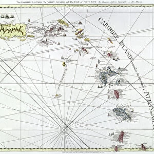
New Map of the English Empire in the Ocean of America or West Indies: Jamaica, Antigua, Tobago, St. Kitts Island, Barbados. Plate taken from an Atlas by John Senex (1678-1740), ca. 1720. Biblioteca Jose Marti, Havana, Cuba
, ca. 1720. Biblioteca Jose Marti, Havana, Cuba")
![]()
Wall Art and Photo Gifts from Fine Art Finder
New Map of the English Empire in the Ocean of America or West Indies: Jamaica, Antigua, Tobago, St. Kitts Island, Barbados. Plate taken from an Atlas by John Senex (1678-1740), ca. 1720. Biblioteca Jose Marti, Havana, Cuba
VEN5031184 New Map of the English Empire in the Ocean of America or West Indies: Jamaica, Antigua, Tobago, St. Kitts Island, Barbados. Plate taken from an Atlas by John Senex (1678-1740), ca. 1720. Biblioteca Jose Marti, Havana, Cuba.; (add.info.: New Map of the English Empire in the Ocean of America or West Indies: Jamaica, Antigua, Tobago, St. Kitts Island, Barbados. Plate taken from an Atlas by John Senex (1678-1740), ca. 1720. Biblioteca Jose Marti, Havana, Cuba.); © Marage Photos
Media ID 38425760
© © Marage Photos / Bridgeman Images
Amerique Centrale Amerique Du Nord Atlantic Ocean Carte Geographique Central America Etats Unis Geographie Jamaica Jamaican Ocean Atlantique Stockravenna 18eme Siecle Geographical Map
FEATURES IN THESE COLLECTIONS
> Animals
> Mammals
> Sciuridae
> Senex
> Arts
> Artists
> S
> John Senex
> Fine Art Finder
> Artists
> Pasquier (workshop of) Grenier
> Maps and Charts
> Early Maps
> North America
> Antigua and Barbuda
> Maps
> North America
> Antigua and Barbuda
> St. John's
> North America
> Barbados
> Maps
> North America
> Barbados
> Related Images
> North America
> Cuba
> Cuba Heritage Sites
> Old Havana and its Fortification System
> North America
> Cuba
> Havana
EDITORS COMMENTS
This stunning print captures a piece of history with the New Map of the English Empire in the Ocean of America or West Indies, showcasing Jamaica, Antigua, Tobago, St. Kitts Island, and Barbados. Created by John Senex in the early 18th century, around 1720, this intricate map provides a glimpse into the colonial era and the vast territories controlled by England at that time.
The detailed cartography and vibrant colors bring to life the geographical features of these Caribbean islands, situated in the Atlantic Ocean. Each island is clearly labeled and depicted with precision, offering viewers a chance to explore their unique landscapes and coastlines.
Displayed at Biblioteca Jose Marti in Havana, Cuba, this historical atlas plate is not just a map but a work of art that reflects the power dynamics and exploration efforts of European nations during this period. It serves as a reminder of how borders have shifted over time and how different cultures have influenced each other through trade and colonization.
As we admire this piece from centuries past, we are reminded of the complex history woven into every inch of land on our planet. The New Map of the English Empire in the Ocean of America is not just a representation of geography but also an invitation to delve deeper into our shared heritage as global citizens.
MADE IN THE USA
Safe Shipping with 30 Day Money Back Guarantee
FREE PERSONALISATION*
We are proud to offer a range of customisation features including Personalised Captions, Color Filters and Picture Zoom Tools
SECURE PAYMENTS
We happily accept a wide range of payment options so you can pay for the things you need in the way that is most convenient for you
* Options may vary by product and licensing agreement. Zoomed Pictures can be adjusted in the Cart.