Fine Art Print > Aerial Photography > Armenia
Fine Art Print : A Picturesque Map of the Seat of War, in the Danubian Provinces, Turkey, Asia Minor, Southern Russia, and the Crimea (engraving)
")


![]()
Fine Art Prints from Fine Art Finder
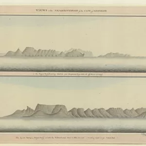
A Picturesque Map of the Seat of War, in the Danubian Provinces, Turkey, Asia Minor, Southern Russia, and the Crimea (engraving)
1607993 A Picturesque Map of the Seat of War, in the Danubian Provinces, Turkey, Asia Minor, Southern Russia, and the Crimea (engraving) by English School, (19th century); Private Collection; (add.info.: A Picturesque Map of the Seat of War, in the Danubian Provinces, Turkey, Asia Minor, Southern Russia, and the Crimea. Illustration for The Illustrated London News, 1854.
English School (19th Century)); Look and Learn / Illustrated Papers Collection
Media ID 23095450
© Look and Learn / Illustrated Papers Collection / Bridgeman Images
Adrianople Aerial Views Anapa Angora Asia Minor Balaclava Balkans Bessarabia Black Sea Bosphorus Bucharest Caspian Sea Caucasia Constantinople Crimea Crimean War Dardanelles Don Cossacks Erzeroum Eupatoria Galatz Gallipoli Georgia Giurgevo Jassy Kars Kronstadt Moldavia Moldavian Moldova Moldovan Mount Ararat Mount Olympus Odessa Old Fort River Danube Romania Romanian Romanians Roumania Rustchuk Schumla Scutari Sea Of Marmora Seat Of War Sebastopol Silistria Sinope Tiflis Transylvania Trebizond Turkish Culture Varna Wallachia Akerman Austria Austrian Austrians Bender Burgas Caffa Carpathian Mountains Caucasus Mountains Central Turkey Erivan Gori Ismid Kherson Matchin Mount Ida Oltenitza River Don Rostov Sea Of Azof Sereth Southern Russia Stavropol Turk
21"x14" (+3" Border) Fine Art Print
Step back in time with our exquisite Fine Art Print of A Picturesque Map of the Seat of War, in the Danubian Provinces, Turkey, Asia Minor, Southern Russia, and the Crimea. This intricately detailed engraving, created by the English School in the late 19th century, offers a captivating glimpse into the historical context of a significant period. The map showcases the various regions involved in the war, including Turkey, Asia Minor, Southern Russia, and the Crimea, providing a rich educational experience. The intricate lines and shading of this vintage map are sure to add an air of sophistication and history to any room in your home or office. Order your Fine Art Print of A Picturesque Map of the Seat of War today and bring a piece of the past into your present.
21x14 image printed on 27x20 Fine Art Rag Paper with 3" (76mm) white border. Our Fine Art Prints are printed on 300gsm 100% acid free, PH neutral paper with archival properties. This printing method is used by museums and art collections to exhibit photographs and art reproductions.
Our fine art prints are high-quality prints made using a paper called Photo Rag. This 100% cotton rag fibre paper is known for its exceptional image sharpness, rich colors, and high level of detail, making it a popular choice for professional photographers and artists. Photo rag paper is our clear recommendation for a fine art paper print. If you can afford to spend more on a higher quality paper, then Photo Rag is our clear recommendation for a fine art paper print.
Estimated Image Size (if not cropped) is 53.3cm x 35.5cm (21" x 14")
Estimated Product Size is 68.6cm x 50.8cm (27" x 20")
These are individually made so all sizes are approximate
Artwork printed orientated as per the preview above, with landscape (horizontal) orientation to match the source image.
FEATURES IN THESE COLLECTIONS
> Fine Art Finder
> Artists
> English School
> Aerial Photography
> Armenia
> Aerial Photography
> Austria
> Aerial Photography
> Georgia
> Aerial Photography
> Moldova
> Aerial Photography
> Related Images
> Aerial Photography
> Romania
> Animals
> Mammals
> Cats (Domestic)
> Turkish Angora
> Animals
> Mammals
> Muridae
> Plains Mouse
EDITORS COMMENTS
This engraving, titled "A Picturesque Map of the Seat of War" takes us back to the 19th century during the Crimean War. The detailed illustration showcases a vast area encompassing the Danubian Provinces, Turkey, Asia Minor, Southern Russia, and the Crimea. It was originally published in The Illustrated London News in 1854. The map offers a fascinating aerial view of this war-torn region with its diverse topography and significant landmarks. From the majestic Mount Ararat to the winding River Danube and the bustling city of Constantinople, every element is meticulously depicted. The viewer's gaze can wander over mountain ranges like the Carpathians and Caucasus Mountains while exploring cities such as Balaclava and Sebastopol. As we study this historical artifact further, it becomes evident that it serves not only as a geographical representation but also as an informative tool for understanding military movements during this turbulent period. It highlights key locations like Silistria and Sinope where crucial battles took place. With its intricate details and artistic flair, this picturesque map transports us back in time to witness one of history's most significant conflicts unfold before our eyes. It reminds us of how art can be used to document important events while simultaneously providing aesthetic pleasure. This particular print is part of a private collection curated by Bridgeman Images' Fine Art Finder platform—a treasure trove for art enthusiasts seeking glimpses into our rich past through visual masterpieces like this one.
MADE IN THE USA
Safe Shipping with 30 Day Money Back Guarantee
FREE PERSONALISATION*
We are proud to offer a range of customisation features including Personalised Captions, Color Filters and Picture Zoom Tools
SECURE PAYMENTS
We happily accept a wide range of payment options so you can pay for the things you need in the way that is most convenient for you
* Options may vary by product and licensing agreement. Zoomed Pictures can be adjusted in the Cart.