Fine Art Print > Europe > France > Canton > Nord
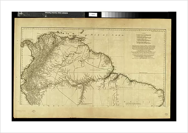
Fine Art Print : Geography map: representation of the northern part of South America (Brazil, Venezuela, Peru) from the Atlas " Amerique meridionale" by French cartographer Jean-Baptiste Bourguignon d'Anville (1697-1782), 1748. Biblioteca Angelica, Rome
 from the Atlas ' Amerique meridionale' by French cartographer Jean-Baptiste Bourguignon d'Anville (1697-1782), 1748. Biblioteca Angelica, Rome")

![]()
Fine Art Prints from Fine Art Finder
Geography map: representation of the northern part of South America (Brazil, Venezuela, Peru) from the Atlas " Amerique meridionale" by French cartographer Jean-Baptiste Bourguignon d'Anville (1697-1782), 1748. Biblioteca Angelica, Rome
VEN5030250 Geography map: representation of the northern part of South America (Brazil, Venezuela, Peru) from the Atlas " Amerique meridionale" by French cartographer Jean-Baptiste Bourguignon d'Anville (1697-1782), 1748. Biblioteca Angelica, Rome; (add.info.: Geography map: representation of the northern part of South America (Brazil, Venezuela, Peru) from the Atlas " Amerique meridionale" by French cartographer Jean-Baptiste Bourguignon d'Anville (1697-1782), 1748. Biblioteca Angelica, Rome); © Marage Photos
Media ID 38350258
© © Marage Photos / Bridgeman Images
Amerique Du Nord Amerique Du Sud Brasil Brazil Brazil Brasilian Brazil Brazilian Brazilian Brazilians Bresil Bresilien Bresilienne Carte Geographique Etats Unis Geographie Latin America Latinamerica Perou Peruvian Southamerica Stockravenna Venezuela Venezuelan 18eme Siecle Geographical Map Latine America
21"x14" (+3" Border) Fine Art Print
Explore the intricate details of South America with this stunning Fine Art Print from Media Storehouse. Featuring a historical map by French cartographer Jean-Baptiste Bourguignon d'Anville, this piece is sure to add a touch of sophistication to any space. Perfect for geography enthusiasts and art lovers alike!
21x14 image printed on 27x20 Fine Art Rag Paper with 3" (76mm) white border. Our Fine Art Prints are printed on 300gsm 100% acid free, PH neutral paper with archival properties. This printing method is used by museums and art collections to exhibit photographs and art reproductions.
Our fine art prints are high-quality prints made using a paper called Photo Rag. This 100% cotton rag fibre paper is known for its exceptional image sharpness, rich colors, and high level of detail, making it a popular choice for professional photographers and artists. Photo rag paper is our clear recommendation for a fine art paper print. If you can afford to spend more on a higher quality paper, then Photo Rag is our clear recommendation for a fine art paper print.
Estimated Image Size (if not cropped) is 53.3cm x 35.5cm (21" x 14")
Estimated Product Size is 68.6cm x 50.8cm (27" x 20")
These are individually made so all sizes are approximate
Artwork printed orientated as per the preview above, with landscape (horizontal) orientation to match the source image.
FEATURES IN THESE COLLECTIONS
> Fine Art Finder
> Artists
> Francois Xavier Fabre
> Europe
> France
> Canton
> Nord
> Maps and Charts
> Early Maps
> North America
> United States of America
> Maps
> South America
> Brazil
> Maps
> South America
> Brazil
> Related Images
> South America
> Peru
> Maps
> South America
> Peru
> Related Images
EDITORS COMMENTS
This stunning print of a geography map, depicting the northern part of South America including Brazil, Venezuela, and Peru, is a true masterpiece from the 18th century. Created by French cartographer Jean-Baptiste Bourguignon d'Anville in 1748, this detailed representation showcases the intricate beauty of the region during that time period.
The map is housed in the Biblioteca Angelica in Rome and provides a glimpse into the geographical knowledge and exploration of the era. With its precise engravings and intricate details, it serves as a valuable historical document for understanding the topography and boundaries of these countries.
From Brazil's vast rainforests to Venezuela's mountainous terrain and Peru's diverse landscapes, this map captures the essence of South America with accuracy and artistry. It highlights not only the physical features but also reflects cultural influences and colonial history prevalent in these regions during that period.
As we admire this piece of cartographic artistry, we are transported back in time to an age when exploration was at its peak and maps were essential tools for navigating unknown territories. The legacy of Jean-Baptiste Bourguignon d'Anville lives on through his meticulous work showcased in this exquisite print.
MADE IN THE USA
Safe Shipping with 30 Day Money Back Guarantee
FREE PERSONALISATION*
We are proud to offer a range of customisation features including Personalised Captions, Color Filters and Picture Zoom Tools
SECURE PAYMENTS
We happily accept a wide range of payment options so you can pay for the things you need in the way that is most convenient for you
* Options may vary by product and licensing agreement. Zoomed Pictures can be adjusted in the Cart.