Fine Art Print > North America > Cuba > Cuba Heritage Sites > Old Havana and its Fortification System
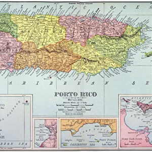
Fine Art Print : Geography: map of Cuba, Puerto Rico and general view of the Caribbean Sea. Map from an Atlas of Camilo Alabern, 1853. Biblioteca Jose Marti, Havana, Cuba


![]()
Fine Art Prints from Fine Art Finder
Geography: map of Cuba, Puerto Rico and general view of the Caribbean Sea. Map from an Atlas of Camilo Alabern, 1853. Biblioteca Jose Marti, Havana, Cuba
VEN5031293 Geography: map of Cuba, Puerto Rico and general view of the Caribbean Sea. Map from an Atlas of Camilo Alabern, 1853. Biblioteca Jose Marti, Havana, Cuba; (add.info.: Geography: map of Cuba, Puerto Rico and general view of the Caribbean Sea. Map from an Atlas of Camilo Alabern, 1853. Biblioteca Jose Marti, Havana, Cuba); © Marage Photos
Media ID 38274522
© © Marage Photos / Bridgeman Images
Amerique Centrale Amerique Du Nord Caraïbes Caribbean Caribbean Island Carte Geographique Central America Cuba Cuba Cubain Cubaine Cubains Cubaines Cuban Etats Unis Geographie Stockravenna Geographical Map
21"x14" (+3" Border) Fine Art Print
Explore the beauty of the Caribbean with this stunning fine art print showcasing a historic map of Cuba, Puerto Rico, and the surrounding seas. A perfect addition to any home or office decor for those who appreciate both history and geography.
21x14 image printed on 27x20 Fine Art Rag Paper with 3" (76mm) white border. Our Fine Art Prints are printed on 300gsm 100% acid free, PH neutral paper with archival properties. This printing method is used by museums and art collections to exhibit photographs and art reproductions.
Our fine art prints are high-quality prints made using a paper called Photo Rag. This 100% cotton rag fibre paper is known for its exceptional image sharpness, rich colors, and high level of detail, making it a popular choice for professional photographers and artists. Photo rag paper is our clear recommendation for a fine art paper print. If you can afford to spend more on a higher quality paper, then Photo Rag is our clear recommendation for a fine art paper print.
Estimated Image Size (if not cropped) is 53.3cm x 35.5cm (21" x 14")
Estimated Product Size is 68.6cm x 50.8cm (27" x 20")
These are individually made so all sizes are approximate
Artwork printed orientated as per the preview above, with landscape (horizontal) orientation to match the source image.
FEATURES IN THESE COLLECTIONS
> Fine Art Finder
> Artists
> Marcantonio Bassetti
> Maps and Charts
> Early Maps
> Maps and Charts
> Related Images
> North America
> Cuba
> Cuba Heritage Sites
> Old Havana and its Fortification System
> North America
> Cuba
> Havana
> North America
> Cuba
> Maps
> North America
> Cuba
> Related Images
> North America
> Puerto Rico
> Maps
> North America
> Puerto Rico
> Related Images
> North America
> United States of America
> Maps
EDITORS COMMENTS
This stunning print captures a piece of history from the 19th century, showcasing a detailed map of Cuba, Puerto Rico, and the general view of the Caribbean Sea. The map is from an Atlas by Camilo Alabern, dating back to 1853 and housed in the Biblioteca Jose Marti in Havana, Cuba.
The intricate engraving highlights the geographical features of these islands in the Western Hemisphere, providing a glimpse into the past when cartography was both art and science. The map serves as a valuable historical document, offering insights into the political boundaries and natural landscapes of this region during that time period.
As we gaze upon this image, we are transported back to an era when exploration and discovery shaped our understanding of the world around us. The vibrant colors and intricate details on display remind us of the rich cultural heritage that defines these Caribbean islands.
Whether you have a personal connection to these lands or simply appreciate their beauty from afar, this print is sure to spark curiosity and admiration for the diverse landscapes found within Cuba, Puerto Rico, and throughout the Caribbean Sea. It serves as a reminder of how interconnected our world truly is across time and space.
MADE IN THE USA
Safe Shipping with 30 Day Money Back Guarantee
FREE PERSONALISATION*
We are proud to offer a range of customisation features including Personalised Captions, Color Filters and Picture Zoom Tools
SECURE PAYMENTS
We happily accept a wide range of payment options so you can pay for the things you need in the way that is most convenient for you
* Options may vary by product and licensing agreement. Zoomed Pictures can be adjusted in the Cart.