Fine Art Print > Animals > Mammals > Soricidae > Navigator
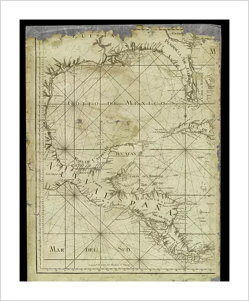
Fine Art Print : Geography: map for navigators representing the Gulf of Mexico, Mexico, Yucatan, Honduras, Nicaragua and Costarica from an Atlas of 1755, Bibliotheque Jose Marti, Havana, Cuba


![]()
Fine Art Prints from Fine Art Finder
Geography: map for navigators representing the Gulf of Mexico, Mexico, Yucatan, Honduras, Nicaragua and Costarica from an Atlas of 1755, Bibliotheque Jose Marti, Havana, Cuba
VEN5031234 Geography: map for navigators representing the Gulf of Mexico, Mexico, Yucatan, Honduras, Nicaragua and Costarica from an Atlas of 1755, Bibliotheque Jose Marti, Havana, Cuba; (add.info.: Geography: map for navigators representing the Gulf of Mexico, Mexico, Yucatan, Honduras, Nicaragua and Costarica from an Atlas of 1755, Bibliotheque Jose Marti, Havana, Cuba); © Marage Photos
Media ID 38164358
© © Marage Photos / Bridgeman Images
Amerique Centrale Amerique Du Nord Carte Geographique Central America Etats Unis Geographie Honduras Mexicans Mexico Mexican Mexique Stockravenna 18eme Siecle Geographical Map
20"x16" (+3" Border) Fine Art Print
Explore the rich history of the Gulf of Mexico with this stunning vintage map from 1755. Perfect for any geography enthusiast or lover of historical art, this Fine Art Print captures the beauty and detail of a bygone era. Add a touch of sophistication to your space with this unique piece from Media Storehouse.
20x16 image printed on 26x22 Fine Art Rag Paper with 3" (76mm) white border. Our Fine Art Prints are printed on 300gsm 100% acid free, PH neutral paper with archival properties. This printing method is used by museums and art collections to exhibit photographs and art reproductions.
Our fine art prints are high-quality prints made using a paper called Photo Rag. This 100% cotton rag fibre paper is known for its exceptional image sharpness, rich colors, and high level of detail, making it a popular choice for professional photographers and artists. Photo rag paper is our clear recommendation for a fine art paper print. If you can afford to spend more on a higher quality paper, then Photo Rag is our clear recommendation for a fine art paper print.
Estimated Image Size (if not cropped) is 40.6cm x 50.8cm (16" x 20")
Estimated Product Size is 55.9cm x 66cm (22" x 26")
These are individually made so all sizes are approximate
Artwork printed orientated as per the preview above, with portrait (vertical) orientation to match the source image.
FEATURES IN THESE COLLECTIONS
> Animals
> Mammals
> Soricidae
> Navigator
> Maps and Charts
> Early Maps
> Maps and Charts
> Related Images
> North America
> Cuba
> Cuba Heritage Sites
> Old Havana and its Fortification System
> North America
> Cuba
> Havana
> North America
> Cuba
> Maps
> North America
> Cuba
> Related Images
> North America
> Honduras
> Maps
> North America
> Honduras
> Related Images
EDITORS COMMENTS
This stunning print captures a piece of history from an Atlas of 1755, housed in the Bibliotheque Jose Marti in Havana, Cuba. The map is a detailed representation of the Gulf of Mexico, Mexico, Yucatan, Honduras, Nicaragua and Costa Rica, providing valuable information for navigators during the 18th century.
The intricate engraving showcases the geographical features of Central America with precision and artistry. From the coastlines to the mountain ranges, every detail is meticulously depicted on this historical map.
As we gaze upon this image, we are transported back in time to an era when exploration and discovery were at the forefront of human endeavor. The map serves as a reminder of the importance of geography in shaping our understanding of the world around us.
Through this photo print, we can appreciate not only the beauty of cartography but also its significance in guiding sailors and travelers through uncharted waters. It stands as a testament to human ingenuity and curiosity about our planet's diverse landscapes.
Let us marvel at this exquisite piece from centuries past and reflect on how far we have come in our quest to explore and understand the world we inhabit.
MADE IN THE USA
Safe Shipping with 30 Day Money Back Guarantee
FREE PERSONALISATION*
We are proud to offer a range of customisation features including Personalised Captions, Color Filters and Picture Zoom Tools
SECURE PAYMENTS
We happily accept a wide range of payment options so you can pay for the things you need in the way that is most convenient for you
* Options may vary by product and licensing agreement. Zoomed Pictures can be adjusted in the Cart.