Fine Art Print > Animals > Insects > Hemiptera > Red Date Scale
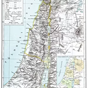
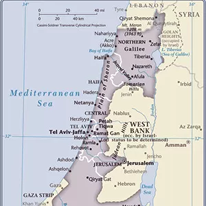
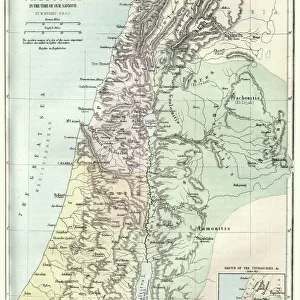
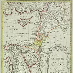
Fine Art Print : Antique map of the Middle East with Egypt, Syria, and Israel


![]()
Fine Art Prints from Fine Art Storehouse
Antique map of the Middle East with Egypt, Syria, and Israel
Antique map of the Middle East with Egypt, Syria, and Israel. Date unknown
Unleash your creativity and transform your space into a visual masterpiece!
Hemera Technologies
Media ID 13667355
© Getty Images
Arabia Border Cyprus Direction Document Egypt Geography Historical Palestine Holy Land Israel Jordan Jordan Middle East Latitude Legend Location Longitude Mediterranean Sea Middle East Persian Gulf Place Positioning Red Sea Scale Sinai Egypt Sinai Peninsula Syria Turkey Turkey Middle East Gulf Of Suez
21"x14" (+3" Border) Fine Art Print
Discover the rich history of the Middle East with this exquisite antique map from the Fine Art Storehouse collection. This beautifully detailed print, featuring Egypt, Syria, and Israel, transports you back in time with its intricate depiction of ancient borders and geographical features. The muted colors and worn edges add to the authenticity of this rare find. Bring a piece of history into your home or office with this stunning fine art print from the Media Storehouse collection by Hemera Technologies.
21x14 image printed on 27x20 Fine Art Rag Paper with 3" (76mm) white border. Our Fine Art Prints are printed on 300gsm 100% acid free, PH neutral paper with archival properties. This printing method is used by museums and art collections to exhibit photographs and art reproductions.
Our fine art prints are high-quality prints made using a paper called Photo Rag. This 100% cotton rag fibre paper is known for its exceptional image sharpness, rich colors, and high level of detail, making it a popular choice for professional photographers and artists. Photo rag paper is our clear recommendation for a fine art paper print. If you can afford to spend more on a higher quality paper, then Photo Rag is our clear recommendation for a fine art paper print.
Estimated Image Size (if not cropped) is 35.5cm x 51.2cm (14" x 20.2")
Estimated Product Size is 50.8cm x 68.6cm (20" x 27")
These are individually made so all sizes are approximate
Artwork printed orientated as per the preview above, with portrait (vertical) orientation to match the source image.
FEATURES IN THESE COLLECTIONS
> Africa
> Egypt
> Related Images
> Animals
> Insects
> Hemiptera
> Red Date Scale
> Arts
> Artists
> S
> Syrian Syrian
> Asia
> Cyprus
> Related Images
> Asia
> Israel
> Related Images
> Fine Art Storehouse
> Map
> Historical Maps
EDITORS COMMENTS
This antique map of the Middle East with Egypt, Syria, and Israel takes us on a journey through time. Its origins remain unknown, adding an air of mystery to its historical significance. The intricate engravings and delicate details showcase the artistry involved in cartography during this era. The map encompasses a vast region, stretching from the Mediterranean Sea to the Persian Gulf, and from Turkey to Arabia. It highlights key locations such as Cyprus, Jordan, and the Sinai Peninsula while providing latitude and longitude coordinates for accurate positioning. As we explore this vintage treasure, we are transported back in time to witness how borders have evolved over centuries. The Holy Land is prominently featured, reminding us of its profound religious importance throughout history. The vibrant colors used in this print bring life to the physical geography depicted - from the Red Sea's deep blues to Europe's lush greens. This visual representation allows us to appreciate not only its historical value but also its aesthetic appeal. With no people present in the image, our focus remains solely on unraveling layers of history embedded within each stroke. This archival document serves as a testament to human curiosity about our world's past and showcases Hemera Technologies' commitment to preserving these invaluable pieces of heritage through their photography. Whether you are a lover of history or simply captivated by ancient cartography techniques, this antique map invites you into an enchanting voyage through time that will surely ignite your imagination.
MADE IN THE USA
Safe Shipping with 30 Day Money Back Guarantee
FREE PERSONALISATION*
We are proud to offer a range of customisation features including Personalised Captions, Color Filters and Picture Zoom Tools
SECURE PAYMENTS
We happily accept a wide range of payment options so you can pay for the things you need in the way that is most convenient for you
* Options may vary by product and licensing agreement. Zoomed Pictures can be adjusted in the Cart.