Fine Art Print > North America > Cuba > Maps
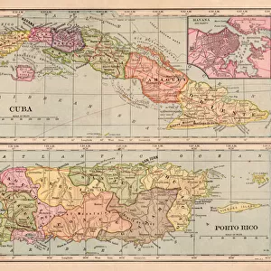
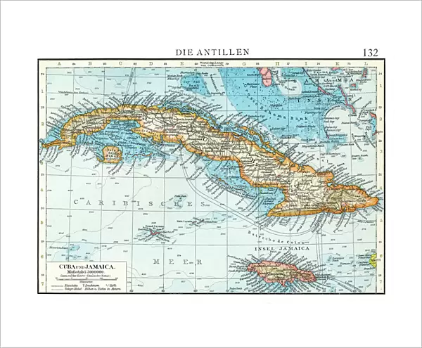
Fine Art Print : Cuba map 1896


![]()
Fine Art Prints from Fine Art Storehouse
Cuba map 1896
Andres Allgemeiner Handatlas - Bielefeld und Leipzig 1896
Unleash your creativity and transform your space into a visual masterpiece!
THEPALMER
Media ID 18356911
20"x16" (+3" Border) Fine Art Print
Discover the rich history and culture of Cuba with this stunning Fine Art Print from Media Storehouse. Featuring an intricately detailed map of Cuba from the Andres Allgemeiner Handatlas published in Bielefeld and Leipzig in 1896 by THEPALMER. This vintage map transports you back in time, offering a unique glimpse into the geography and political boundaries of the island nation over a century ago. Add an air of sophistication and historical charm to any room with this beautiful and authentic piece of cartographic art.
20x16 image printed on 26x22 Fine Art Rag Paper with 3" (76mm) white border. Our Fine Art Prints are printed on 300gsm 100% acid free, PH neutral paper with archival properties. This printing method is used by museums and art collections to exhibit photographs and art reproductions.
Our fine art prints are high-quality prints made using a paper called Photo Rag. This 100% cotton rag fibre paper is known for its exceptional image sharpness, rich colors, and high level of detail, making it a popular choice for professional photographers and artists. Photo rag paper is our clear recommendation for a fine art paper print. If you can afford to spend more on a higher quality paper, then Photo Rag is our clear recommendation for a fine art paper print.
Estimated Image Size (if not cropped) is 50.8cm x 36cm (20" x 14.2")
Estimated Product Size is 66cm x 55.9cm (26" x 22")
These are individually made so all sizes are approximate
Artwork printed orientated as per the preview above, with landscape (horizontal) orientation to match the source image.
FEATURES IN THESE COLLECTIONS
> Maps and Charts
> Related Images
> North America
> Cuba
> Maps
> North America
> Cuba
> Related Images
> Fine Art Storehouse
> Map
> Historical Maps
> Fine Art Storehouse
> Top Sellers - Art Prints
EDITORS COMMENTS
This print of the "Cuba map 1896" takes us on a journey back in time to the enchanting island during an era of great historical significance. The intricate details and vibrant colors showcased in this piece, sourced from Andres Allgemeiner Handatlas - Bielefeld und Leipzig 1896, transport us to a bygone era when maps were meticulously crafted works of art. The map itself is a testament to the craftsmanship and attention to detail that went into cartography during this period. Every contour, river, and city is delicately illustrated with precision and accuracy. It serves as both a geographical guide and a window into Cuba's rich history. As we gaze upon this vintage treasure, our imagination runs wild with thoughts of explorers navigating through lush landscapes, bustling towns brimming with life, and hidden treasures waiting to be discovered. We are reminded of Cuba's diverse topography; from its stunning coastline adorned with pristine beaches to its rugged mountain ranges shrouded in mystery. Beyond its aesthetic appeal, this photograph also offers us an opportunity for reflection. It reminds us how far we have come in terms of technological advancements while simultaneously evoking nostalgia for simpler times when maps were tangible objects that required human touch. "The Cuba map 1896" by THEPALMER captures not only the beauty but also the essence of an era long gone. It invites us to delve deep into history while appreciating the artistry behind every line drawn on paper—a true masterpiece that stands as a
MADE IN THE USA
Safe Shipping with 30 Day Money Back Guarantee
FREE PERSONALISATION*
We are proud to offer a range of customisation features including Personalised Captions, Color Filters and Picture Zoom Tools
SECURE PAYMENTS
We happily accept a wide range of payment options so you can pay for the things you need in the way that is most convenient for you
* Options may vary by product and licensing agreement. Zoomed Pictures can be adjusted in the Cart.