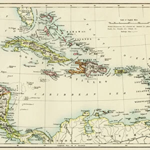
Metal Print > North America > Cuba > Maps
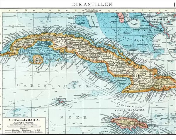
Metal Print : Cuba map 1896


![]()
Metal Prints from Fine Art Storehouse
Cuba map 1896
Andres Allgemeiner Handatlas - Bielefeld und Leipzig 1896
Unleash your creativity and transform your space into a visual masterpiece!
THEPALMER
Media ID 18356911
16"x20" (51x41cm) Metal Print
Discover the rich history of Cuba with our stunning Metal Print of the Andres Allgemeiner Handatlas map from 1896, available in the Media Storehouse range. This intricately detailed map, titled "Cuba," was published by THEPALMER in Bielefeld and Leipzig. Our Metal Prints are not just a decorative addition to your space, they are a conversation starter and a journey back in time. The vibrant colors and sharp details pop against the sleek, modern metal surface, ensuring your map remains a captivating centerpiece. Bring a piece of historical cartography into your home or office with our high-quality Metal Print of the Cuba map from 1896.
Made with durable metal and luxurious printing techniques, our metal photo prints go beyond traditional canvases, adding a cool, modern touch to your space. Wall mount on back. Eco-friendly 100% post-consumer recycled ChromaLuxe aluminum surface. The thickness of the print is 0.045". Featuring a Scratch-resistant surface and Rounded corners. Backing hangers are attached to the back of the print and float the print 1/2-inch off the wall when hung, the choice of hanger may vary depending on size and International orders will come with Float Mount hangers only. Finished with a brilliant white high gloss surface for unsurpassed detail and vibrance. Printed using Dye-Sublimation and for best care we recommend a non-ammonia glass cleaner, water, or isopropyl (rubbing) alcohol to prevent harming the print surface. We recommend using a clean, lint-free cloth to wipe off the print. The ultra-hard surface is scratch-resistant, waterproof and weatherproof. Avoid direct sunlight exposure.
Made with durable metal and luxurious printing techniques, metal prints bring images to life and add a modern touch to any space
Estimated Image Size (if not cropped) is 50.8cm x 40.6cm (20" x 16")
Estimated Product Size is 51.4cm x 41.2cm (20.2" x 16.2")
These are individually made so all sizes are approximate
Artwork printed orientated as per the preview above, with landscape (horizontal) orientation to match the source image.
FEATURES IN THESE COLLECTIONS
> Fine Art Storehouse
> Map
> Historical Maps
> Fine Art Storehouse
> Top Sellers - Art Prints
> Maps and Charts
> Related Images
> North America
> Cuba
> Maps
> North America
> Cuba
> Related Images
EDITORS COMMENTS
This print of the "Cuba map 1896" takes us on a journey back in time to the enchanting island during an era of great historical significance. The intricate details and vibrant colors showcased in this piece, sourced from Andres Allgemeiner Handatlas - Bielefeld und Leipzig 1896, transport us to a bygone era when maps were meticulously crafted works of art. The map itself is a testament to the craftsmanship and attention to detail that went into cartography during this period. Every contour, river, and city is delicately illustrated with precision and accuracy. It serves as both a geographical guide and a window into Cuba's rich history. As we gaze upon this vintage treasure, our imagination runs wild with thoughts of explorers navigating through lush landscapes, bustling towns brimming with life, and hidden treasures waiting to be discovered. We are reminded of Cuba's diverse topography; from its stunning coastline adorned with pristine beaches to its rugged mountain ranges shrouded in mystery. Beyond its aesthetic appeal, this photograph also offers us an opportunity for reflection. It reminds us how far we have come in terms of technological advancements while simultaneously evoking nostalgia for simpler times when maps were tangible objects that required human touch. "The Cuba map 1896" by THEPALMER captures not only the beauty but also the essence of an era long gone. It invites us to delve deep into history while appreciating the artistry behind every line drawn on paper—a true masterpiece that stands as a
MADE IN THE USA
Safe Shipping with 30 Day Money Back Guarantee
FREE PERSONALISATION*
We are proud to offer a range of customisation features including Personalised Captions, Color Filters and Picture Zoom Tools
SECURE PAYMENTS
We happily accept a wide range of payment options so you can pay for the things you need in the way that is most convenient for you
* Options may vary by product and licensing agreement. Zoomed Pictures can be adjusted in the Cart.