Framed Print > North America > Cuba > Maps
Framed Print : Cuba map 1896


![]()
Framed Photos from Fine Art Storehouse
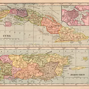
Cuba map 1896
Andres Allgemeiner Handatlas - Bielefeld und Leipzig 1896
Unleash your creativity and transform your space into a visual masterpiece!
THEPALMER
Media ID 18356911
12"x10" Modern Frame
Introducing the Cuba Map 1896 Framed Print from Media Storehouse's Fine Art Storehouse collection. This exquisite piece of historical cartography is taken from Andres Allgemeiner Handatlas, published in Bielefeld and Leipzig in 1896 by THEPALMER. The map showcases intricate details of Cuba's geography during that era, making it a captivating addition to any room. Embrace the charm of vintage maps and transport yourself back in time with this beautifully framed print. Perfect for history enthusiasts, world travelers, or those who appreciate the aesthetics of antique maps. Add this unique piece to your home or office decor and start a conversation about the rich history of Cuba.
10x8 Print in an MDF Wooden Frame with 180 gsm Satin Finish Paper. Glazed using shatter proof thin plexi glass. Frame thickness is 1 inch and depth 0.75 inch. Fluted cardboard backing held with clips. Supplied ready to hang with sawtooth hanger and rubber bumpers. Spot clean with a damp cloth. Packaged foam wrapped in a card.
Contemporary Framed and Mounted Prints - Professionally Made and Ready to Hang
Estimated Image Size (if not cropped) is 25.4cm x 25.4cm (10" x 10")
Estimated Product Size is 30.5cm x 25.4cm (12" x 10")
These are individually made so all sizes are approximate
Artwork printed orientated as per the preview above, with landscape (horizontal) or portrait (vertical) orientation to match the source image.
FEATURES IN THESE COLLECTIONS
> Fine Art Storehouse
> Map
> Historical Maps
> Fine Art Storehouse
> Top Sellers - Art Prints
> Maps and Charts
> Related Images
> North America
> Cuba
> Maps
> North America
> Cuba
> Related Images
EDITORS COMMENTS
This print of the "Cuba map 1896" takes us on a journey back in time to the enchanting island during an era of great historical significance. The intricate details and vibrant colors showcased in this piece, sourced from Andres Allgemeiner Handatlas - Bielefeld und Leipzig 1896, transport us to a bygone era when maps were meticulously crafted works of art. The map itself is a testament to the craftsmanship and attention to detail that went into cartography during this period. Every contour, river, and city is delicately illustrated with precision and accuracy. It serves as both a geographical guide and a window into Cuba's rich history. As we gaze upon this vintage treasure, our imagination runs wild with thoughts of explorers navigating through lush landscapes, bustling towns brimming with life, and hidden treasures waiting to be discovered. We are reminded of Cuba's diverse topography; from its stunning coastline adorned with pristine beaches to its rugged mountain ranges shrouded in mystery. Beyond its aesthetic appeal, this photograph also offers us an opportunity for reflection. It reminds us how far we have come in terms of technological advancements while simultaneously evoking nostalgia for simpler times when maps were tangible objects that required human touch. "The Cuba map 1896" by THEPALMER captures not only the beauty but also the essence of an era long gone. It invites us to delve deep into history while appreciating the artistry behind every line drawn on paper—a true masterpiece that stands as a
MADE IN THE USA
Safe Shipping with 30 Day Money Back Guarantee
FREE PERSONALISATION*
We are proud to offer a range of customisation features including Personalised Captions, Color Filters and Picture Zoom Tools
SECURE PAYMENTS
We happily accept a wide range of payment options so you can pay for the things you need in the way that is most convenient for you
* Options may vary by product and licensing agreement. Zoomed Pictures can be adjusted in the Cart.