Fine Art Print > Arts > Artists > J > Thomas Jefferys
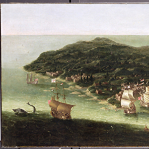
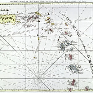
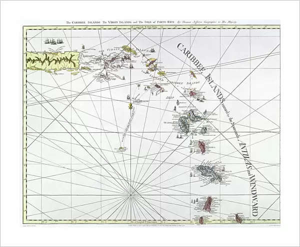
Fine Art Print : CARIBBEAN: MAP, 1775. English engraved map of The Caribee Islands from Puerto Rico to Barbados by Thomas Jefferys, 1775


![]()
Fine Art Prints from Granger
CARIBBEAN: MAP, 1775. English engraved map of The Caribee Islands from Puerto Rico to Barbados by Thomas Jefferys, 1775
Granger holds millions of images spanning more than 25,000 years of world history, from before the Stone Age to the dawn of the Space Age
Media ID 7563845
1775 Caribbean Carribean Colony Geography Island Latin America Navigation Portolan Chart Puerto Rico Virgin Islands West Indies Antilles Windward
20"x16" (+3" Border) Fine Art Print
Step back in time with our exquisite Fine Art Print of the Caribbean: MAP, 1775 by Thomas Jefferys. This English engraved map, published in 1775, offers a captivating glimpse into the historical geography of the Caribbean islands, stretching from Puerto Rico to Barbados. With intricate detail and vibrant colors, this antique map transports you to a bygone era. Bring a piece of history into your home or office with our high-quality Fine Art Print from The Granger Collection, now available through Media Storehouse.
20x16 image printed on 26x22 Fine Art Rag Paper with 3" (76mm) white border. Our Fine Art Prints are printed on 300gsm 100% acid free, PH neutral paper with archival properties. This printing method is used by museums and art collections to exhibit photographs and art reproductions.
Our fine art prints are high-quality prints made using a paper called Photo Rag. This 100% cotton rag fibre paper is known for its exceptional image sharpness, rich colors, and high level of detail, making it a popular choice for professional photographers and artists. Photo rag paper is our clear recommendation for a fine art paper print. If you can afford to spend more on a higher quality paper, then Photo Rag is our clear recommendation for a fine art paper print.
Estimated Image Size (if not cropped) is 50.8cm x 40.6cm (20" x 16")
Estimated Product Size is 66cm x 55.9cm (26" x 22")
These are individually made so all sizes are approximate
Artwork printed orientated as per the preview above, with landscape (horizontal) orientation to match the source image.
FEATURES IN THESE COLLECTIONS
> Arts
> Artists
> J
> Thomas Jefferys
> Maps and Charts
> Related Images
> North America
> Barbados
> Maps
> North America
> Barbados
> Related Images
> North America
> Puerto Rico
> Maps
> North America
> Puerto Rico
> Related Images
> North America
> US Virgin Islands
> Maps
EDITORS COMMENTS
This print showcases an exquisite English engraved map of the Caribee Islands, dating back to 1775. Created by the talented cartographer Thomas Jefferys, this late 18th-century masterpiece offers a fascinating glimpse into the geography and navigation of the Caribbean region. The intricate details on this nautical map stretch from Puerto Rico to Barbados, encompassing various islands such as Antilles, Virgin Islands, and Windward. It serves as a testament to the rich colonial history that shaped these lands in Latin America. Engraved with utmost precision and artistry, this vintage piece is not only a visual delight but also a valuable historical artifact. Its inclusion in The Granger Collection's Carousel Collection further highlights its significance as it represents an era when portolan charts played a vital role in maritime exploration. As you immerse yourself in this remarkable print, allow your imagination to wander through time and space. Picture sailors relying on maps like these to navigate treacherous waters while discovering new territories within the West Indies. Let it transport you back to an age where adventure awaited at every turn. Whether you are an avid historian or simply appreciate fine art, this print is sure to captivate your senses and spark curiosity about the enchanting world of Caribbean exploration.
MADE IN THE USA
Safe Shipping with 30 Day Money Back Guarantee
FREE PERSONALISATION*
We are proud to offer a range of customisation features including Personalised Captions, Color Filters and Picture Zoom Tools
SECURE PAYMENTS
We happily accept a wide range of payment options so you can pay for the things you need in the way that is most convenient for you
* Options may vary by product and licensing agreement. Zoomed Pictures can be adjusted in the Cart.