Metal Print > Arts > Artists > J > Thomas Jefferys
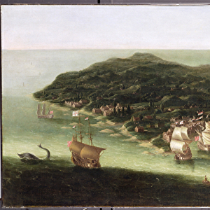
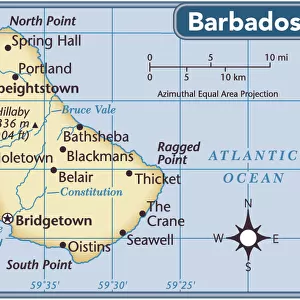
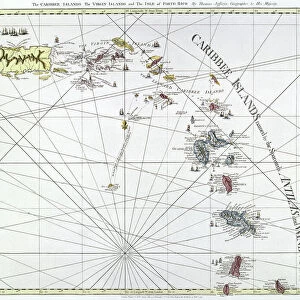
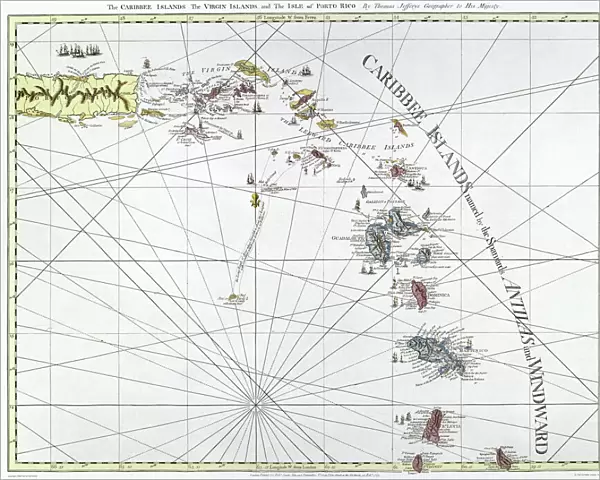
Metal Print : CARIBBEAN: MAP, 1775. English engraved map of The Caribee Islands from Puerto Rico to Barbados by Thomas Jefferys, 1775


![]()
Metal Prints from Granger
CARIBBEAN: MAP, 1775. English engraved map of The Caribee Islands from Puerto Rico to Barbados by Thomas Jefferys, 1775
Granger holds millions of images spanning more than 25,000 years of world history, from before the Stone Age to the dawn of the Space Age
Media ID 7563845
1775 Caribbean Carribean Colony Geography Island Latin America Navigation Portolan Chart Puerto Rico Virgin Islands West Indies Antilles Windward
16"x20" (51x41cm) Metal Print
Discover the rich history of the Caribbean with our stunning Metal Print of the English engraved map of The Caribee Islands by Thomas Jefferys, dated 1775. This exquisite piece, sourced from The Granger Collection through Granger Art on Demand, showcases intricate detail and beautiful antiquity. Bring the allure of the Caribbean right into your home or office with this unique and captivating decor piece. Perfect for history enthusiasts, cartography collectors, or anyone who appreciates the beauty of vintage maps. Order your Metal Print today and let the stories of the past come alive in your space.
Made with durable metal and luxurious printing techniques, our metal photo prints go beyond traditional canvases, adding a cool, modern touch to your space. Wall mount on back. Eco-friendly 100% post-consumer recycled ChromaLuxe aluminum surface. The thickness of the print is 0.045". Featuring a Scratch-resistant surface and Rounded corners. Backing hangers are attached to the back of the print and float the print 1/2-inch off the wall when hung, the choice of hanger may vary depending on size and International orders will come with Float Mount hangers only. Finished with a brilliant white high gloss surface for unsurpassed detail and vibrance. Printed using Dye-Sublimation and for best care we recommend a non-ammonia glass cleaner, water, or isopropyl (rubbing) alcohol to prevent harming the print surface. We recommend using a clean, lint-free cloth to wipe off the print. The ultra-hard surface is scratch-resistant, waterproof and weatherproof. Avoid direct sunlight exposure.
Made with durable metal and luxurious printing techniques, metal prints bring images to life and add a modern touch to any space
Estimated Image Size (if not cropped) is 50.8cm x 40.6cm (20" x 16")
Estimated Product Size is 51.4cm x 41.2cm (20.2" x 16.2")
These are individually made so all sizes are approximate
Artwork printed orientated as per the preview above, with landscape (horizontal) orientation to match the source image.
FEATURES IN THESE COLLECTIONS
> Arts
> Artists
> J
> Thomas Jefferys
> Maps and Charts
> Related Images
> North America
> Barbados
> Maps
> North America
> Barbados
> Related Images
> North America
> Puerto Rico
> Maps
> North America
> Puerto Rico
> Related Images
> North America
> US Virgin Islands
> Maps
EDITORS COMMENTS
This print showcases an exquisite English engraved map of the Caribee Islands, dating back to 1775. Created by the talented cartographer Thomas Jefferys, this late 18th-century masterpiece offers a fascinating glimpse into the geography and navigation of the Caribbean region. The intricate details on this nautical map stretch from Puerto Rico to Barbados, encompassing various islands such as Antilles, Virgin Islands, and Windward. It serves as a testament to the rich colonial history that shaped these lands in Latin America. Engraved with utmost precision and artistry, this vintage piece is not only a visual delight but also a valuable historical artifact. Its inclusion in The Granger Collection's Carousel Collection further highlights its significance as it represents an era when portolan charts played a vital role in maritime exploration. As you immerse yourself in this remarkable print, allow your imagination to wander through time and space. Picture sailors relying on maps like these to navigate treacherous waters while discovering new territories within the West Indies. Let it transport you back to an age where adventure awaited at every turn. Whether you are an avid historian or simply appreciate fine art, this print is sure to captivate your senses and spark curiosity about the enchanting world of Caribbean exploration.
MADE IN THE USA
Safe Shipping with 30 Day Money Back Guarantee
FREE PERSONALISATION*
We are proud to offer a range of customisation features including Personalised Captions, Color Filters and Picture Zoom Tools
SECURE PAYMENTS
We happily accept a wide range of payment options so you can pay for the things you need in the way that is most convenient for you
* Options may vary by product and licensing agreement. Zoomed Pictures can be adjusted in the Cart.