Fine Art Print > Europe > United Kingdom > Scotland > Highlands > Wick
Fine Art Print : Map La carte nouvelle de la France ses conquetes


![]()
Fine Art Prints from Liszt Collection
Map La carte nouvelle de la France ses conquetes
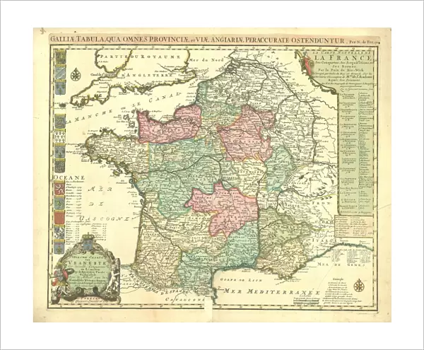
Map, La carte nouvelle de la France, ses conquetes, ses acquisitions, et ses bornes. Par la paix de Ris-wick =, Nicolas de Fer (1646-1720), Copperplate print
Liszt Collection of nineteenth-century engravings and images to browse and enjoy
Media ID 19586277
© Artokoloro
20"x16" (+3" Border) Fine Art Print
Discover the rich history and artistic beauty of the past with Media Storehouse's Fine Art Prints. This exquisite piece showcases the Map of New France, its Conquests, Acquisitions, and Borders, from the renowned Liszt Collection. Dating back to 1693, this intricately detailed copperplate print by Nicolas de Fer offers a captivating glimpse into the territorial expansion of France during that era. Add this stunning work of art to your collection and bring a piece of history into your home or office.
20x16 image printed on 26x22 Fine Art Rag Paper with 3" (76mm) white border. Our Fine Art Prints are printed on 300gsm 100% acid free, PH neutral paper with archival properties. This printing method is used by museums and art collections to exhibit photographs and art reproductions.
Our fine art prints are high-quality prints made using a paper called Photo Rag. This 100% cotton rag fibre paper is known for its exceptional image sharpness, rich colors, and high level of detail, making it a popular choice for professional photographers and artists. Photo rag paper is our clear recommendation for a fine art paper print. If you can afford to spend more on a higher quality paper, then Photo Rag is our clear recommendation for a fine art paper print.
Estimated Image Size (if not cropped) is 49.3cm x 40.6cm (19.4" x 16")
Estimated Product Size is 66cm x 55.9cm (26" x 22")
These are individually made so all sizes are approximate
Artwork printed orientated as per the preview above, with landscape (horizontal) orientation to match the source image.
FEATURES IN THESE COLLECTIONS
> Arts
> Artists
> D
> Nicolas de Fer
> Europe
> United Kingdom
> Scotland
> Highlands
> Wick
> Maps and Charts
> Related Images
EDITORS COMMENTS
This print showcases the historical map titled "La carte nouvelle de la France, ses conquêtes, ses acquisitions, et ses bornes. Par la paix de Ris-wick" by Nicolas de Fer. Created during the years 1646-1720 using copperplate print technique, this exquisite piece of art offers a glimpse into the cartographic mastery of its creator. The map depicts France and its territorial expansions with intricate detail and precision. It highlights the conquests, acquisitions, and boundaries of France as determined by the Peace Treaty of Ryswick. The viewer is transported back in time to an era where cartography played a crucial role in shaping political landscapes. Nicolas de Fer's expertise shines through in this remarkable work as he skillfully captures every geographical feature and boundary line with meticulous accuracy. The rich colors used in this copperplate print add depth and vibrancy to each region depicted on the map. As we admire this print from Liszt Collection, we are reminded of how maps have not only served practical purposes but also acted as visual representations of power dynamics throughout history. This particular artwork serves as a testament to both De Fer's talent as a cartographer and his contribution to documenting France's ever-changing borders during that period
MADE IN THE USA
Safe Shipping with 30 Day Money Back Guarantee
FREE PERSONALISATION*
We are proud to offer a range of customisation features including Personalised Captions, Color Filters and Picture Zoom Tools
SECURE PAYMENTS
We happily accept a wide range of payment options so you can pay for the things you need in the way that is most convenient for you
* Options may vary by product and licensing agreement. Zoomed Pictures can be adjusted in the Cart.