Photo Mug > Europe > United Kingdom > Scotland > Highlands > Wick
Photo Mug : Map La carte nouvelle de la France ses conquetes


![]()
Home Decor from Liszt Collection
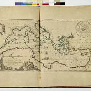
Map La carte nouvelle de la France ses conquetes
Map, La carte nouvelle de la France, ses conquetes, ses acquisitions, et ses bornes. Par la paix de Ris-wick =, Nicolas de Fer (1646-1720), Copperplate print
Liszt Collection of nineteenth-century engravings and images to browse and enjoy
Media ID 19586277
© Artokoloro
Large Photo Mug (15 oz)
Add a touch of history to your morning routine with our Media Storehouse Photo Mugs, featuring the stunning Map La carte nouvelle de la France ses conquetes from the Liszt Collection. This exquisite copperplate print, created by Nicolas de Fer in 1693, showcases the expansive territorial gains of France during that era. Each mug holds your favorite beverage while providing a captivating visual journey through time. Perfect for history enthusiasts or as a unique gift, our Photo Mugs bring art and function together in perfect harmony.
Elevate your coffee or tea experience with our premium white ceramic mug. Its wide, comfortable handle makes drinking easy, and you can rely on it to be both microwave and dishwasher safe. Sold in single units, preview may show both sides of the same mug so you can see how the picture wraps around.
Elevate your coffee or tea experience with our premium white ceramic mug. Its wide, comfortable handle makes drinking easy, and you can rely on it to be both microwave and dishwasher safe. Sold in single units, preview may show both sides of the same mug so you can see how the picture wraps around.
These are individually made so all sizes are approximate
FEATURES IN THESE COLLECTIONS
> Arts
> Artists
> D
> Nicolas de Fer
> Europe
> United Kingdom
> Scotland
> Highlands
> Wick
> Maps and Charts
> Related Images
EDITORS COMMENTS
This print showcases the historical map titled "La carte nouvelle de la France, ses conquêtes, ses acquisitions, et ses bornes. Par la paix de Ris-wick" by Nicolas de Fer. Created during the years 1646-1720 using copperplate print technique, this exquisite piece of art offers a glimpse into the cartographic mastery of its creator. The map depicts France and its territorial expansions with intricate detail and precision. It highlights the conquests, acquisitions, and boundaries of France as determined by the Peace Treaty of Ryswick. The viewer is transported back in time to an era where cartography played a crucial role in shaping political landscapes. Nicolas de Fer's expertise shines through in this remarkable work as he skillfully captures every geographical feature and boundary line with meticulous accuracy. The rich colors used in this copperplate print add depth and vibrancy to each region depicted on the map. As we admire this print from Liszt Collection, we are reminded of how maps have not only served practical purposes but also acted as visual representations of power dynamics throughout history. This particular artwork serves as a testament to both De Fer's talent as a cartographer and his contribution to documenting France's ever-changing borders during that period
MADE IN THE USA
Safe Shipping with 30 Day Money Back Guarantee
FREE PERSONALISATION*
We are proud to offer a range of customisation features including Personalised Captions, Color Filters and Picture Zoom Tools
SECURE PAYMENTS
We happily accept a wide range of payment options so you can pay for the things you need in the way that is most convenient for you
* Options may vary by product and licensing agreement. Zoomed Pictures can be adjusted in the Cart.