Poster Print > Europe > United Kingdom > Scotland > Highlands > Wick
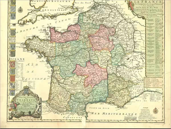
Poster Print : Map La carte nouvelle de la France ses conquetes


![]()
Poster Prints from Liszt Collection
Map La carte nouvelle de la France ses conquetes
Map, La carte nouvelle de la France, ses conquetes, ses acquisitions, et ses bornes. Par la paix de Ris-wick =, Nicolas de Fer (1646-1720), Copperplate print
Liszt Collection of nineteenth-century engravings and images to browse and enjoy
Media ID 19586277
© Artokoloro
18x24 inch Poster Print
Discover the rich history of France's territorial expansion with our stunning Map La carte nouvelle de la France from the esteemed Liszt Collection. This exquisite poster print, featuring the intricately detailed copperplate work of Nicolas de Fer, showcases France's conquests, acquisitions, and borders as of the Peace of Ryswick in 1697. Bring a piece of historical cartography into your home or office and transport yourself back in time with this captivating and educational poster print from Media Storehouse's collection.
Poster prints are budget friendly enlarged prints in standard poster paper sizes. Printed on 150 gsm Matte Paper for a natural feel and supplied rolled in a tube. Great for framing and should last many years. To clean wipe with a microfiber, non-abrasive cloth or napkin. Our Archival Quality Photo Prints and Fine Art Paper Prints are printed on higher quality paper and the choice of which largely depends on your budget.
Poster prints are budget friendly enlarged prints in standard poster paper sizes (A0, A1, A2, A3 etc). Whilst poster paper is sometimes thinner and less durable than our other paper types, they are still ok for framing and should last many years. Our Archival Quality Photo Prints and Fine Art Paper Prints are printed on higher quality paper and the choice of which largely depends on your budget.
Estimated Product Size is 61.6cm x 46.3cm (24.3" x 18.2")
These are individually made so all sizes are approximate
Artwork printed orientated as per the preview above, with landscape (horizontal) orientation to match the source image.
FEATURES IN THESE COLLECTIONS
> Arts
> Artists
> D
> Nicolas de Fer
> Europe
> United Kingdom
> Scotland
> Highlands
> Wick
> Maps and Charts
> Related Images
EDITORS COMMENTS
This print showcases the historical map titled "La carte nouvelle de la France, ses conquêtes, ses acquisitions, et ses bornes. Par la paix de Ris-wick" by Nicolas de Fer. Created during the years 1646-1720 using copperplate print technique, this exquisite piece of art offers a glimpse into the cartographic mastery of its creator. The map depicts France and its territorial expansions with intricate detail and precision. It highlights the conquests, acquisitions, and boundaries of France as determined by the Peace Treaty of Ryswick. The viewer is transported back in time to an era where cartography played a crucial role in shaping political landscapes. Nicolas de Fer's expertise shines through in this remarkable work as he skillfully captures every geographical feature and boundary line with meticulous accuracy. The rich colors used in this copperplate print add depth and vibrancy to each region depicted on the map. As we admire this print from Liszt Collection, we are reminded of how maps have not only served practical purposes but also acted as visual representations of power dynamics throughout history. This particular artwork serves as a testament to both De Fer's talent as a cartographer and his contribution to documenting France's ever-changing borders during that period
MADE IN THE USA
Safe Shipping with 30 Day Money Back Guarantee
FREE PERSONALISATION*
We are proud to offer a range of customisation features including Personalised Captions, Color Filters and Picture Zoom Tools
SECURE PAYMENTS
We happily accept a wide range of payment options so you can pay for the things you need in the way that is most convenient for you
* Options may vary by product and licensing agreement. Zoomed Pictures can be adjusted in the Cart.