Fine Art Print > Europe > Republic of Ireland > Maps
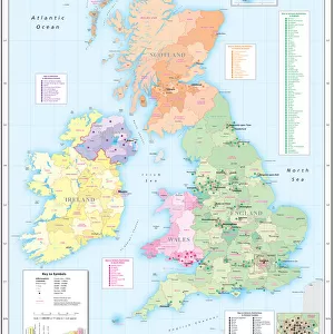
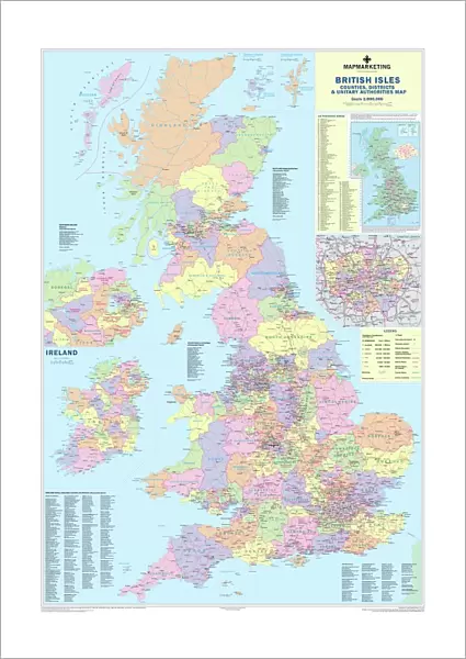
Fine Art Print : British Isles Counties, Districts and Unitary Authorities Map

![]()
Fine Art Prints from Map Marketing
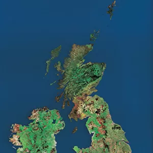
British Isles Counties, Districts and Unitary Authorities Map
A political map of the UK and Ireland showing all County, District and Unitary Authority boundaries. Each County is clearly divided into its local District Council areas and each administrative area is shown in a different colour to its neighbours. The map base shows towns, cities motorways and primary roads. Includes a small Postcode Area inset map and a London Borough map. Ireland shown as an inset with all County boundaries for the Republic. Population figures are displayed by administrative division
Media ID 19949237
© Map Marketing Ltd
21"x14" (+3" Border) Fine Art Print
21x14 image printed on 27x20 Fine Art Rag Paper with 3" (76mm) white border. Our Fine Art Prints are printed on 300gsm 100% acid free, PH neutral paper with archival properties. This printing method is used by museums and art collections to exhibit photographs and art reproductions.
Our fine art prints are high-quality prints made using a paper called Photo Rag. This 100% cotton rag fibre paper is known for its exceptional image sharpness, rich colors, and high level of detail, making it a popular choice for professional photographers and artists. Photo rag paper is our clear recommendation for a fine art paper print. If you can afford to spend more on a higher quality paper, then Photo Rag is our clear recommendation for a fine art paper print.
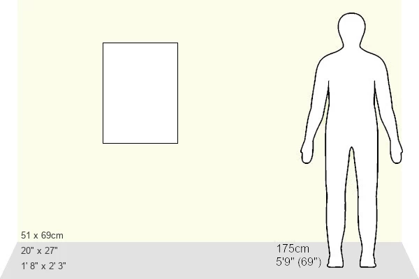
Estimated Image Size (if not cropped) is 35.5cm x 53.3cm (14" x 21")
Estimated Product Size is 50.8cm x 68.6cm (20" x 27")
These are individually made so all sizes are approximate
Artwork printed orientated as per the preview above, with portrait (vertical) orientation to match the source image.
FEATURES IN THESE COLLECTIONS
> Europe
> Republic of Ireland
> Maps
> Europe
> Republic of Ireland
> Related Images
> Europe
> United Kingdom
> England
> London
> Boroughs
> Related Images
> Europe
> United Kingdom
> England
> London
> Politics
> Related Images
> Europe
> United Kingdom
> Maps
> Maps and Charts
> Popular Maps
> Maps and Charts
> Related Images
> Map Marketing
> UK Maps
MADE IN THE USA
Safe Shipping with 30 Day Money Back Guarantee
FREE PERSONALISATION*
We are proud to offer a range of customisation features including Personalised Captions, Color Filters and Picture Zoom Tools
SECURE PAYMENTS
We happily accept a wide range of payment options so you can pay for the things you need in the way that is most convenient for you
* Options may vary by product and licensing agreement. Zoomed Pictures can be adjusted in the Cart.