Photographic Print > Europe > Republic of Ireland > Maps
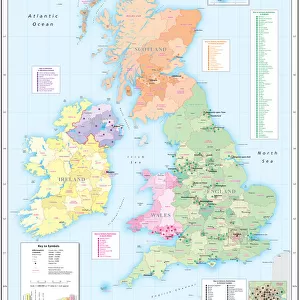
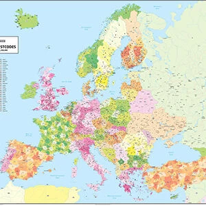
Photographic Print : British Isles Counties, Districts and Unitary Authorities Map

![]()
Photo Prints from Map Marketing
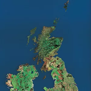
British Isles Counties, Districts and Unitary Authorities Map
A political map of the UK and Ireland showing all County, District and Unitary Authority boundaries. Each County is clearly divided into its local District Council areas and each administrative area is shown in a different colour to its neighbours. The map base shows towns, cities motorways and primary roads. Includes a small Postcode Area inset map and a London Borough map. Ireland shown as an inset with all County boundaries for the Republic. Population figures are displayed by administrative division
Media ID 19949237
© Map Marketing Ltd
11"x8.5" Photo Print
Photo prints are produced on Kodak professional photo paper resulting in timeless and breath-taking prints which are also ideal for framing. The colors produced are rich and vivid, with accurate blacks and pristine whites, resulting in prints that are truly timeless and magnificent. Whether you're looking to display your prints in your home, office, or gallery, our range of photographic prints are sure to impress. Dimensions refers to the size of the paper in inches.
Our Photo Prints are in a large range of sizes and are printed on Archival Quality Paper for excellent colour reproduction and longevity. They are ideal for framing (our Framed Prints use these) at a reasonable cost. Alternatives include cheaper Poster Prints and higher quality Fine Art Paper, the choice of which is largely dependant on your budget.
Estimated Image Size (if not cropped) is 19cm x 27.9cm (7.5" x 11")
Estimated Product Size is 21.6cm x 27.9cm (8.5" x 11")
These are individually made so all sizes are approximate
Artwork printed orientated as per the preview above, with portrait (vertical) orientation to match the source image.
FEATURES IN THESE COLLECTIONS
> Map Marketing
> UK Maps
> Europe
> Republic of Ireland
> Maps
> Europe
> Republic of Ireland
> Related Images
> Europe
> United Kingdom
> England
> London
> Boroughs
> Related Images
> Europe
> United Kingdom
> England
> London
> Politics
> Related Images
> Europe
> United Kingdom
> Maps
> Maps and Charts
> Popular Maps
> Maps and Charts
> Related Images
MADE IN THE USA
Safe Shipping with 30 Day Money Back Guarantee
FREE PERSONALISATION*
We are proud to offer a range of customisation features including Personalised Captions, Color Filters and Picture Zoom Tools
SECURE PAYMENTS
We happily accept a wide range of payment options so you can pay for the things you need in the way that is most convenient for you
* Options may vary by product and licensing agreement. Zoomed Pictures can be adjusted in the Cart.