Poster Print > Europe > Republic of Ireland > Maps
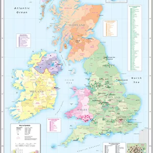
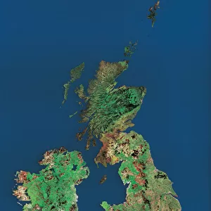
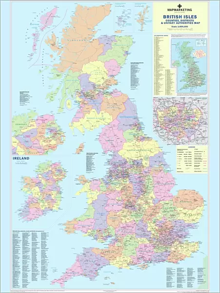
Poster Print : British Isles Counties, Districts and Unitary Authorities Map


![]()
Poster Prints from Map Marketing
British Isles Counties, Districts and Unitary Authorities Map
A political map of the UK and Ireland showing all County, District and Unitary Authority boundaries. Each County is clearly divided into its local District Council areas and each administrative area is shown in a different colour to its neighbours. The map base shows towns, cities motorways and primary roads. Includes a small Postcode Area inset map and a London Borough map. Ireland shown as an inset with all County boundaries for the Republic. Population figures are displayed by administrative division
Media ID 19949237
© Map Marketing Ltd
18x24 inch Poster Print
Poster prints are budget friendly enlarged prints in standard poster paper sizes. Printed on 150 gsm Matte Paper for a natural feel and supplied rolled in a tube. Great for framing and should last many years. To clean wipe with a microfiber, non-abrasive cloth or napkin. Our Archival Quality Photo Prints and Fine Art Paper Prints are printed on higher quality paper and the choice of which largely depends on your budget.
Poster prints are budget friendly enlarged prints in standard poster paper sizes (A0, A1, A2, A3 etc). Whilst poster paper is sometimes thinner and less durable than our other paper types, they are still ok for framing and should last many years. Our Archival Quality Photo Prints and Fine Art Paper Prints are printed on higher quality paper and the choice of which largely depends on your budget.
Estimated Image Size (if not cropped) is 41.9cm x 61.5cm (16.5" x 24.2")
Estimated Product Size is 46.3cm x 61.6cm (18.2" x 24.3")
These are individually made so all sizes are approximate
Artwork printed orientated as per the preview above, with portrait (vertical) orientation to match the source image.
FEATURES IN THESE COLLECTIONS
> Map Marketing
> UK Maps
> Europe
> Republic of Ireland
> Maps
> Europe
> Republic of Ireland
> Related Images
> Europe
> United Kingdom
> England
> London
> Boroughs
> Related Images
> Europe
> United Kingdom
> England
> London
> Politics
> Related Images
> Europe
> United Kingdom
> Maps
> Maps and Charts
> Popular Maps
> Maps and Charts
> Related Images
MADE IN THE USA
Safe Shipping with 30 Day Money Back Guarantee
FREE PERSONALISATION*
We are proud to offer a range of customisation features including Personalised Captions, Color Filters and Picture Zoom Tools
SECURE PAYMENTS
We happily accept a wide range of payment options so you can pay for the things you need in the way that is most convenient for you
* Options may vary by product and licensing agreement. Zoomed Pictures can be adjusted in the Cart.