Fine Art Print > Arts > Artists > O > Oceanic Oceanic
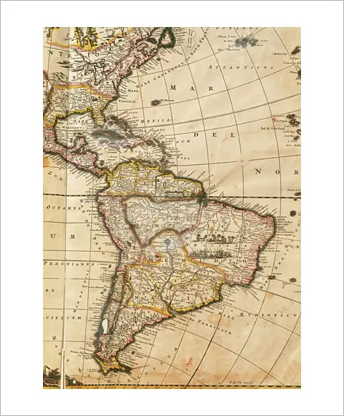
Fine Art Print : Map of America. Nova Totius Americae Descriptio by Frederik


![]()
Fine Art Prints from Mary Evans Picture Library
Map of America. Nova Totius Americae Descriptio by Frederik
Nova Totius Americae Descriptio. Map of America. By Frederik de Wit (1630-1706). Amsterdam, 1666
Mary Evans Picture Library makes available wonderful images created for people to enjoy over the centuries
Media ID 14330246
© Thaliastock / Mary Evans
1666 Americas Amsterdam Antilles Atlantic Atlas Cartographic Cartography Descriptio Frederic Frederik Holland Netherlands Nova Pacific Totius Witt Americae
20"x16" (+3" Border) Fine Art Print
Discover the captivating beauty of history with our exquisite selection of Fine Art Prints from Media Storehouse. This particular print showcases the intricate detail and masterful craftsmanship of Frederik de Wit's Nova Totius Americae Descriptio map of America. Dated 1666, this rare and enchanting work of art was originally published in Amsterdam. With its vibrant colors and meticulous depiction of the American continent as it was known during the 17th century, this print is a must-have for history enthusiasts, cartography collectors, or anyone seeking to add a touch of timeless elegance to their home or office decor. Our Fine Art Prints are available through Rights Managed licensing from Mary Evans Prints Online, ensuring the highest quality reproduction and authenticity.
20x16 image printed on 26x22 Fine Art Rag Paper with 3" (76mm) white border. Our Fine Art Prints are printed on 300gsm 100% acid free, PH neutral paper with archival properties. This printing method is used by museums and art collections to exhibit photographs and art reproductions.
Our fine art prints are high-quality prints made using a paper called Photo Rag. This 100% cotton rag fibre paper is known for its exceptional image sharpness, rich colors, and high level of detail, making it a popular choice for professional photographers and artists. Photo rag paper is our clear recommendation for a fine art paper print. If you can afford to spend more on a higher quality paper, then Photo Rag is our clear recommendation for a fine art paper print.
Estimated Image Size (if not cropped) is 36.2cm x 50.8cm (14.3" x 20")
Estimated Product Size is 55.9cm x 66cm (22" x 26")
These are individually made so all sizes are approximate
Artwork printed orientated as per the preview above, with portrait (vertical) orientation to match the source image.
FEATURES IN THESE COLLECTIONS
> Arts
> Artists
> O
> Oceanic Oceanic
> Europe
> Netherlands
> Amsterdam
> Europe
> Netherlands
> Maps
> Europe
> Netherlands
> Posters
> Europe
> Netherlands
> Related Images
> Maps and Charts
> Early Maps
> Maps and Charts
> Netherlands
> Maps and Charts
> Related Images
Nova Totius Americae Descriptio,
EDITORS COMMENTS
or "A New and Accurate Description of the Whole America," is a remarkable map produced by the renowned Dutch cartographer Frederik de Wit in 1666. This intricately detailed map, published in Amsterdam, offers an unprecedented representation of the Americas during the 17th century. The map is a testament to the advancements in cartography during the modern age, showcasing the latest discoveries and knowledge of the New World. The map covers the entirety of North and South America, including the Caribbean islands, with an exceptional level of detail. The Atlantic and Pacific Oceans frame the map, highlighting the importance of maritime exploration in the discovery and understanding of the American continents. The map includes numerous place names, many of which are still used today, and accurately depicts the coastlines, rivers, and topographical features. Frederik de Wit was a prominent figure in the cartographic world of the Netherlands during the late 17th century. His work was highly regarded for its accuracy and detail, and "Nova Totius Americae Descriptio" is a prime example of his skill. The map was produced during a time when European powers were actively exploring and colonizing the Americas, making it a valuable resource for navigators, explorers, and scholars. This map also reflects the growing interest in the natural history and geography of the New World, which was fueled by the Age of Discovery. The intricate detail and accurate representation of the Americas on this map demonstrate the significant progress that had been made in cartography during this period. Today, "Nova Totius Americae Descriptio" remains an important historical document, providing valuable insights into the exploration and understanding of the Americas during the 17th century.
MADE IN THE USA
Safe Shipping with 30 Day Money Back Guarantee
FREE PERSONALISATION*
We are proud to offer a range of customisation features including Personalised Captions, Color Filters and Picture Zoom Tools
SECURE PAYMENTS
We happily accept a wide range of payment options so you can pay for the things you need in the way that is most convenient for you
* Options may vary by product and licensing agreement. Zoomed Pictures can be adjusted in the Cart.