Metal Print > Arts > Artists > O > Oceanic Oceanic
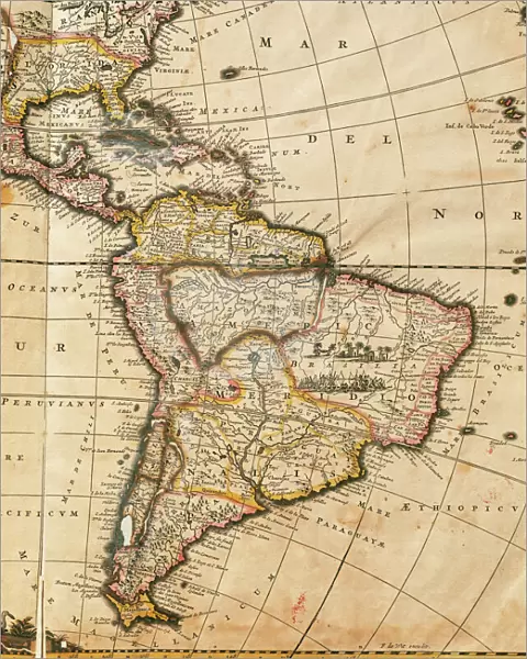
Metal Print : Map of America. Nova Totius Americae Descriptio by Frederik


![]()
Metal Prints from Mary Evans Picture Library
Map of America. Nova Totius Americae Descriptio by Frederik
Nova Totius Americae Descriptio. Map of America. By Frederik de Wit (1630-1706). Amsterdam, 1666
Mary Evans Picture Library makes available wonderful images created for people to enjoy over the centuries
Media ID 14330246
© Thaliastock / Mary Evans
1666 Americas Amsterdam Antilles Atlantic Atlas Cartographic Cartography Descriptio Frederic Frederik Holland Netherlands Nova Pacific Totius Witt Americae
16"x20" (51x41cm) Metal Print
Discover the captivating beauty of the past with our Media Storehouse Metal Print of the historic map, Nova Totius Americae Descriptio by Frederik de Wit. This exquisite map, published in Amsterdam in 1666, offers a fascinating glimpse into the cartographic knowledge of the time. With intricate detail and vivid colors, this metal print brings the map to life, making it a stunning addition to any room. The map, rights-managed from Mary Evans Prints Online, showcases the known world of America during the 17th century, a must-have for history enthusiasts, cartography collectors, or anyone who appreciates the art of mapmaking. Order now and let this piece of history become a conversation starter in your home or office.
Made with durable metal and luxurious printing techniques, our metal photo prints go beyond traditional canvases, adding a cool, modern touch to your space. Wall mount on back. Eco-friendly 100% post-consumer recycled ChromaLuxe aluminum surface. The thickness of the print is 0.045". Featuring a Scratch-resistant surface and Rounded corners. Backing hangers are attached to the back of the print and float the print 1/2-inch off the wall when hung, the choice of hanger may vary depending on size and International orders will come with Float Mount hangers only. Finished with a brilliant white high gloss surface for unsurpassed detail and vibrance. Printed using Dye-Sublimation and for best care we recommend a non-ammonia glass cleaner, water, or isopropyl (rubbing) alcohol to prevent harming the print surface. We recommend using a clean, lint-free cloth to wipe off the print. The ultra-hard surface is scratch-resistant, waterproof and weatherproof. Avoid direct sunlight exposure.
Made with durable metal and luxurious printing techniques, metal prints bring images to life and add a modern touch to any space
Estimated Image Size (if not cropped) is 40.6cm x 50.8cm (16" x 20")
Estimated Product Size is 41.2cm x 51.4cm (16.2" x 20.2")
These are individually made so all sizes are approximate
Artwork printed orientated as per the preview above, with portrait (vertical) orientation to match the source image.
FEATURES IN THESE COLLECTIONS
> Arts
> Artists
> O
> Oceanic Oceanic
> Europe
> Netherlands
> Amsterdam
> Europe
> Netherlands
> Maps
> Europe
> Netherlands
> Posters
> Europe
> Netherlands
> Related Images
> Maps and Charts
> Early Maps
> Maps and Charts
> Netherlands
> Maps and Charts
> Related Images
Nova Totius Americae Descriptio,
EDITORS COMMENTS
or "A New and Accurate Description of the Whole America," is a remarkable map produced by the renowned Dutch cartographer Frederik de Wit in 1666. This intricately detailed map, published in Amsterdam, offers an unprecedented representation of the Americas during the 17th century. The map is a testament to the advancements in cartography during the modern age, showcasing the latest discoveries and knowledge of the New World. The map covers the entirety of North and South America, including the Caribbean islands, with an exceptional level of detail. The Atlantic and Pacific Oceans frame the map, highlighting the importance of maritime exploration in the discovery and understanding of the American continents. The map includes numerous place names, many of which are still used today, and accurately depicts the coastlines, rivers, and topographical features. Frederik de Wit was a prominent figure in the cartographic world of the Netherlands during the late 17th century. His work was highly regarded for its accuracy and detail, and "Nova Totius Americae Descriptio" is a prime example of his skill. The map was produced during a time when European powers were actively exploring and colonizing the Americas, making it a valuable resource for navigators, explorers, and scholars. This map also reflects the growing interest in the natural history and geography of the New World, which was fueled by the Age of Discovery. The intricate detail and accurate representation of the Americas on this map demonstrate the significant progress that had been made in cartography during this period. Today, "Nova Totius Americae Descriptio" remains an important historical document, providing valuable insights into the exploration and understanding of the Americas during the 17th century.
MADE IN THE USA
Safe Shipping with 30 Day Money Back Guarantee
FREE PERSONALISATION*
We are proud to offer a range of customisation features including Personalised Captions, Color Filters and Picture Zoom Tools
SECURE PAYMENTS
We happily accept a wide range of payment options so you can pay for the things you need in the way that is most convenient for you
* Options may vary by product and licensing agreement. Zoomed Pictures can be adjusted in the Cart.